Prairies: Heavy snow, bitter cold to overtake warmer conditions for many

Milder temperatures across the southeastern Prairies continue to drop from west to east as a passing system delivers heavy snow through Thursday
Snow has wrapped up for the western Prairies but temperatures continue to drop from west to east, as a system gears up to bring significant snowfall to Manitoba and parts of Saskatchewan.
For more details on those system and a look at what's next, see below.
WEATHER HIGHLIGHTS
Snowfall warnings, special weather statements in effect for Saskatchewan & Manitoba as snow continues
Eastern Manitoba to see rain for the Winnipeg area through late Wednesday
Eastern and western Manitoba will see a temperature difference close to 10 C on Wednesday
Second system to track into Manitoba Thursday, with freezing rain, ice pellets, and widespread snow
Keep on top of ALERTS in your area
WEDNESDAY INTO THURSDAY: SNOW, RAIN PUSHES INTO MANITOBA
Snow has ended for much of Alberta but temperatures are expected to remain 15-20 C below seasonal through Friday. April 1 is also expected to be one of the coldest April days on record for Calgary.
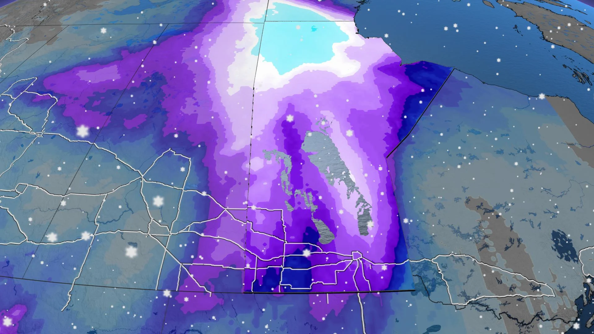
Southwestern Manitoba, meanwhile, will see a surge of moisture trek in from western Montana, bringing heavy snow to the Saskatchewan-Manitoba border by the evening hours on Thursday.

Up to 30 cm are expected across northern Manitoba, while Brandon, Winnipeg and their surrounding areas are forecast to see between 15-20 cm of snow. Locally, some pockets could see up to 25 cm.
"Winnipeg's average April snow is 10.6 cm, so by the time this system passes, it could bring Winnipeg double it's normal April snowfall," The Weather Network meteorologist Kelly Sonnenburg said.
A swath of eastern Saskatchewan is also forecast to receive 15-20 cm of snow with this system.
For southern Manitoba, lesser rainfall totals will be seen first, stretching into northwestern Ontario.

Freezing rain and ice pellets pre-dawn Thursday could also make for icy travel conditions through extreme southern Manitoba.
FRIDAY AND BEYOND: MORE SNOW FOR EASTERN PRAIRIES, FRIGID AIR EASES
Snow and blowing snow will continue across Manitoba through Friday, with moderate snowfall also lingering across northern regions throughout the day.
Into the evening hours on Friday, snow will ease across southern Manitoba and Saskatchewan.
The frigid pattern is expected to ease on the weekend and temperatures will rebound to near-seasonal for early next week. However, another shot of Arctic air is expected for the end of next week and colder than seasonal temperatures will dominate into mid-April.
LOOKING AHEAD: SPRING FLOOD RISK
Though the Winter was a drier one across much of the Prairies, if a similar active pattern continues through the Spring southern Manitoba will need to closely monitor its risk for flooding – particularly along the Red River.
Stay tuned to The Weather Network as we continue to monitor the forecast.