Unrelenting deluge floods the East Coast with 100-200 mm of rain

Flooding remains a threat in parts of Atlantic Canada Wednesday as a stalling low brings persistent, extreme rainfall.
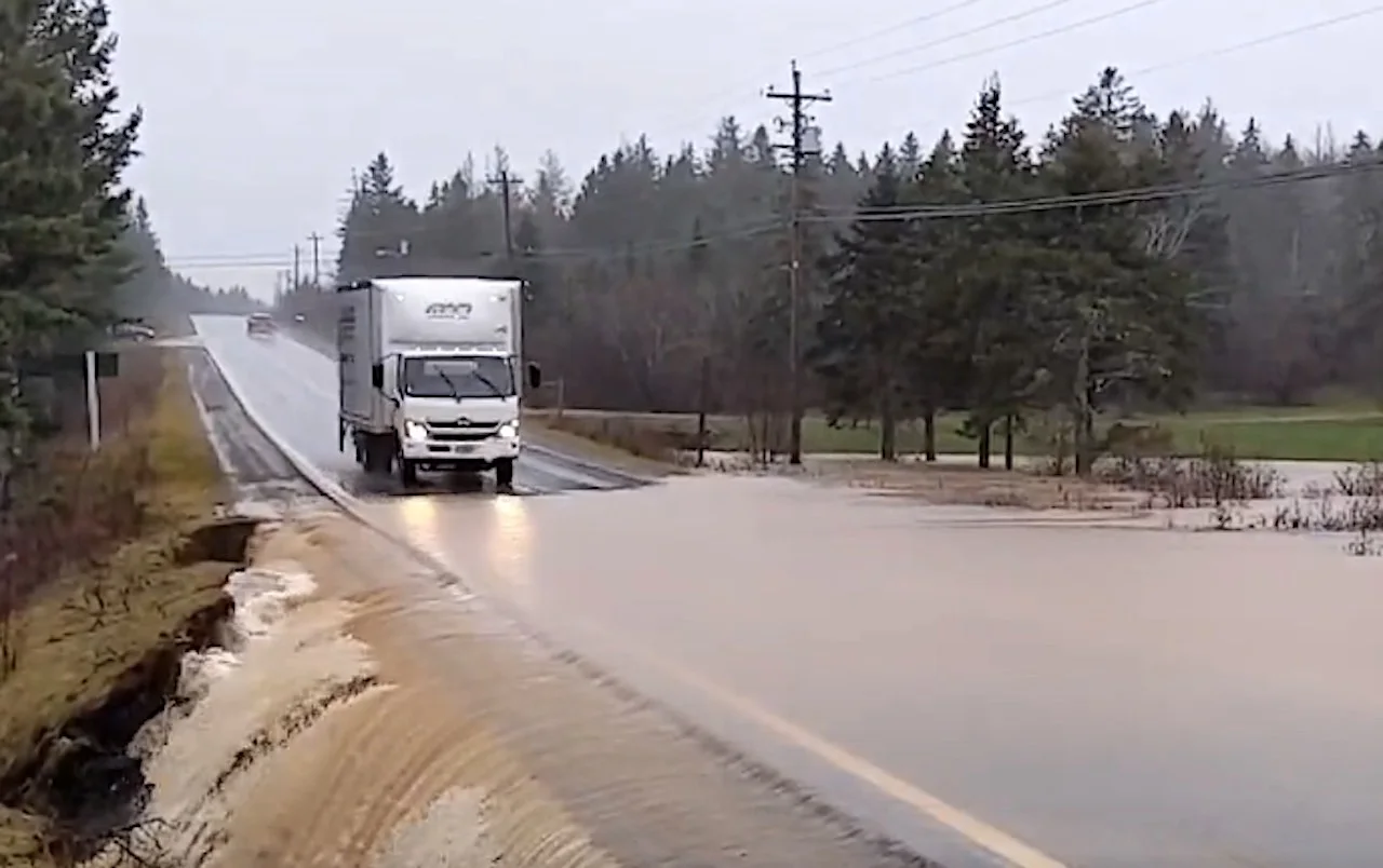
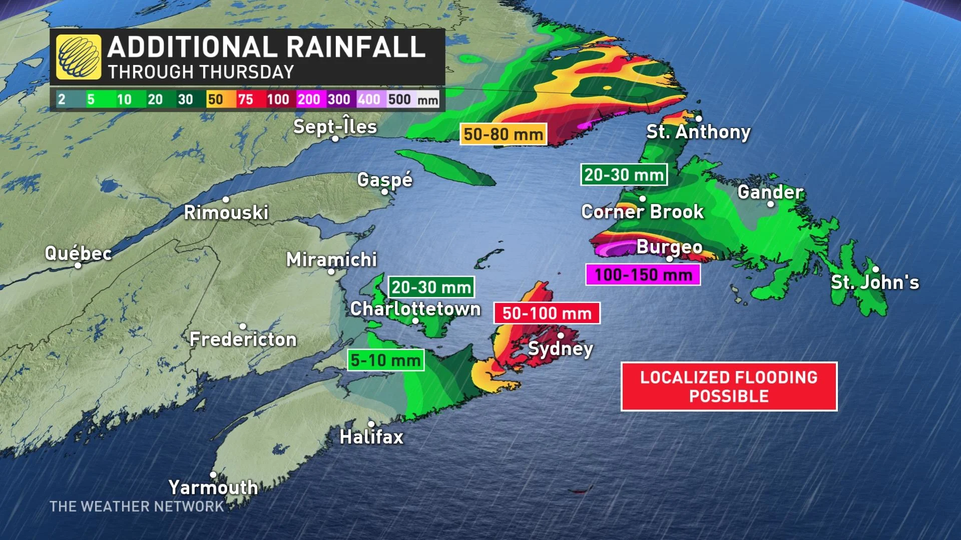
Many areas on the East Coast are being hammered by an atmospheric river this week, with most of the impacts felt in Nova Scotia Tuesday. Excessive rainfall washed out and closed roads, and intense winds knocked out power to thousands. While some areas have seen it subside, there is still left to come for eastern Nova Scotia and southwestern Newfoundland Wednesday. In fact, an additional 50-150 mm of rain is expected across the aforementioned regions, so flooding is likely to continue. More on the impacts and what's left to come Wednesday, below.
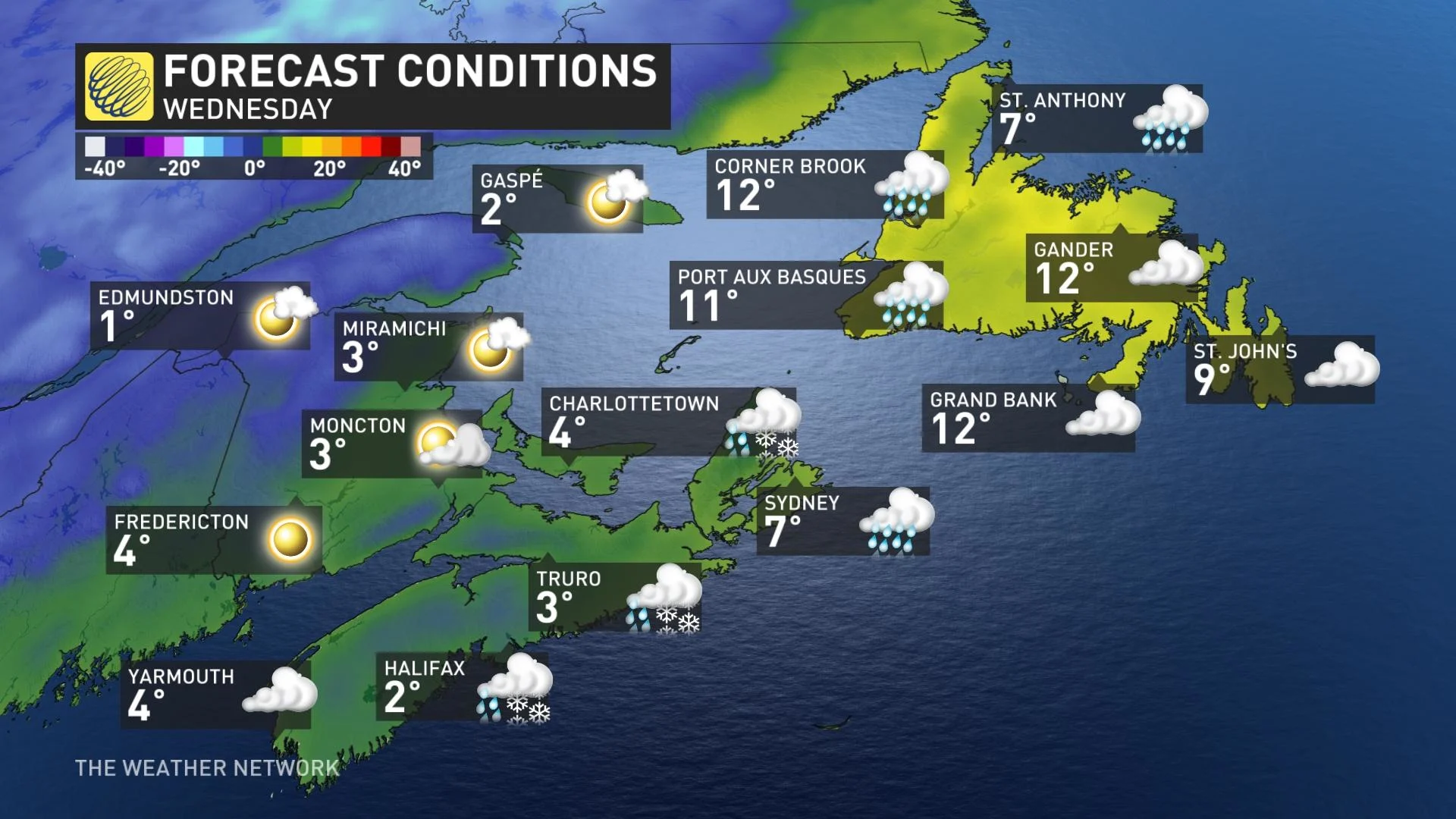
WEDNESDAY: FLOODING RAINS LINGER IN EASTERN NOVA SCOTIA, SOUTHWESTERN NEWFOUNDLAND
Much of the Maritimes are seeing a tremendous amount of Gulf and subtropical moisture this week, with numerous lows trekking across. Tuesday saw the storm knock out power to thousands across Nova Scotia, the cancellation of crossings and flooding closing several roadways including a section of Highway 245 near Antigonish.
In addition to those impacts, Ingonish Beach, N.S., set an all-time single-day rainfall record with 211.2 mm as of 8:00 p.m. ADT Tuesday.
Localized flooding will remain a concern Wednesday as the deluge continues through the morning for Cape Breton, N.S., before easing. Meanwhile, southwestern Newfoundland will continue to be battered by heavy rain into the afternoon hours.
On Wednesday, a strong blocking high across the east will force this system to retrograde, essentially moving backwards from east to west, continuing to impact much of the Maritimes with ongoing rain.
As well, the Maritimes will see daytime highs drop drastically in the wake of the frontal boundary passing Tuesday overnight into early Wednesday morning.
As a result, there is the slight risk of rain transitioning over to a wintry mix --brief freezing rain, ice pellets or wet snow -- as temperatures remain below freezing. Slick conditions are quite possible for areas including Halifax, N.S., and into southern New Brunswick early Wednesday morning and lasting into the overnight period.
Rainfall and wind warnings, along with special weather statements eastern Nova Scotia and parts of southwestern Newfoundland.
RELATED: How to prepare for this week's rainstorm
Rainfall totals have been excessive already, and there is plenty more to come through Thursday. Cape Breton may see an additional 50-100 mm, while southwestern Newfoundland may pick up a further 100-150 mm of rainfall. Needless to say, more flooding is likely.
"There is the potential for localized flooding, flash floods and water pooling on roadways. Travelers should expect to encounter adverse driving conditions," Environment and Climate Change Canada (ECCC) warns.
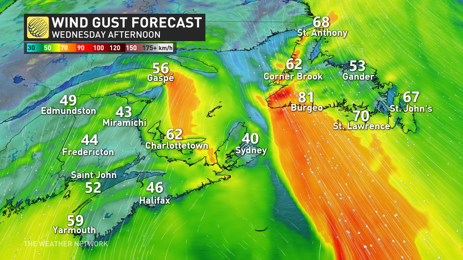
Wind gusts will ease through Tuesday overnight, but gusty conditions will persist for coastal sections on Wednesday
EXCESSIVE RAINFALL BRINGS FLOODS, INTENSE WINDS KNOCK OUT POWER IN ATLANTIC CANADA
LOOK AHEAD: WINDY, UNSETTLED WEATHER LINGERS
Beyond, windy and unsettled weather will continue through Saturday, but the heavy rain will be over before the start of the long range on Thursday. Low pressure over the Atlantic, south of the region, will continue to meander through the end of the week and then merge with another system approaching from the west into the weekend.
A strong blocking pattern over the North Atlantic is responsible for this extended period of unsettled weather as it is preventing the system from escaping out to sea. Temperatures will be very mild, including a couple days of double digits for Newfoundland, in the southerly flow ahead of the system.
Meanwhile, forecasters are watching the potential for heavy snow for northwestern New Brunswick late Friday through Saturday.
FLOOD PREVENTION TIPS
Because of the bout of drenching rains and intense winds this week, planning ahead is the best way to mitigate flood risk. While some damages are unavoidable, taking an assessment ahead of time can make a huge difference.
Checking your insurance is certainly key, and there are a few things you can do around the home to prepare.
Sealing your basement to prevent water from seeping into creeks
Raising electrical system components as high as possible
Making sure your sump pumps are working properly
If a big storm is coming, consider stocking up on supplies, like: sandbags, plywood, plastic sheeting and shovels

(Getty Images)
As well, if you can, arrange to leave your car in a high-elevation area, and avoid driving in flooded areas at all costs.
For other safety tips, click here.
Thumbnail courtesy of Twitter user @smitty 1993, taken in Maryvale, N.S.
Be sure to check back for the latest updates across Atlantic Canada.