Sally threatens U.S. Gulf Coast, with more storms intensifying in the Atlantic

As the Atlantic hurricane season hits its peak this month, the basin continues to churn out storms and disturbances that are keeping forecasters busy.
Several forecasters predicted an above-average Atlantic hurricane season, and have been proven right, with multiple named storms being their earliest of their letter on record.
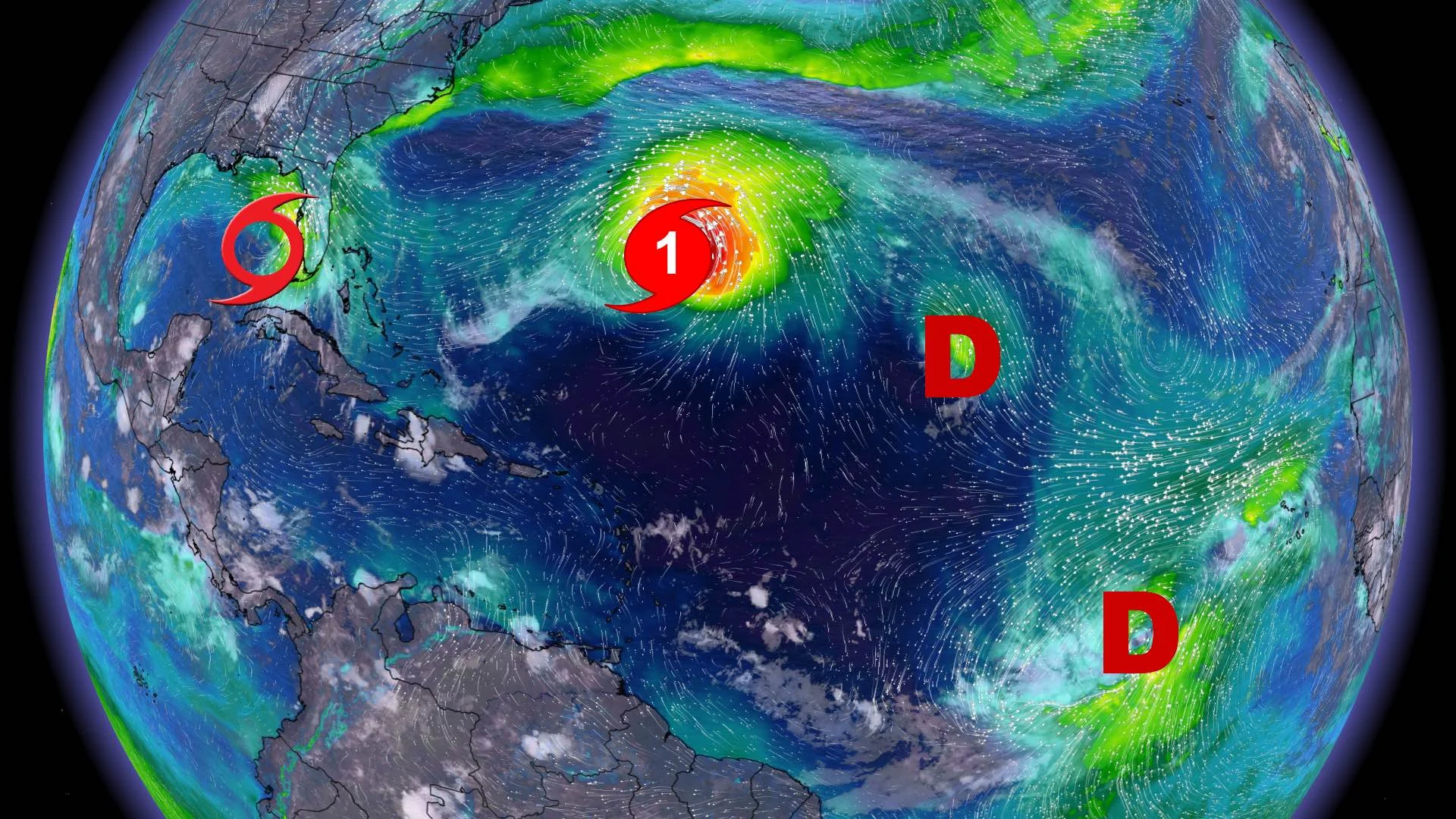
With September being the peak month of the hurricane season, the Atlantic is full of activity – from tropical storms Sally and Paulette, as well as Tropical Depression 20, to disturbances near West Africa coast that show signs of development in the next five days.
SALLY TARGETS FLORIDA, GULF COAST
Forecasters are keeping a close eye on Tropical Storm Sally, as it is expected to continue its intensification, likely becoming a hurricane Monday as it makes its way towards the U.S. Gulf Coast.
Hurricane warnings have already been issued along the Louisiana and Mississippi coasts, while a watch is in effect for Ocean Springs, Miss. to the Alabama/Florida border. Tropical storm warnings and watches are in effect for parts of Mississippi and Florida.
As Sunday morning, the National Hurricane Center says Sally sits 250 km west of Port Charlotte, Fla. and is moving west-northwest near 20 km/h. Sally is set to move a north-northwest Tuesday.

"On the forecast track, the centre of Sally will move over the southeastern and eastern Gulf of Mexico Sunday, over the north-central Gulf of Mexico Sunday night and Monday and approach the north-central Gulf Coast within the hurricane warning area late Monday and Tuesday," the NHC says.
Maximum sustained winds are near 85 km/h, with higher gusts. Strengthening is expected over the next couple of days and Sally is forecast to become a hurricane on Monday, with some additional strengthening possible through early Tuesday.
The storm surge is expected to be significant and dangerous, with 2.1 to 3.5 metres forecast in parts of Mississippi, 1.25 to 2.1 metres in parts of the Mississippi River extending to Port Fourchon, La.
Additional rainfall amounts of 25-75 mm, with isolated totals of up to 150 mm, are expected across southern and central Florida through Monday. This rainfall will produce flash and urban flooding and prolong high flows and ongoing minor flooding on rivers across central areas.

As well, Sally is expected to produce rainfall amounts of 150 to 300 mm, with isolated amounts of more than 500 mm over portions of the central Gulf Coast between the western Florida Panhandle and far southeast Louisiana from Monday into the middle of the week. Rainfall totals of 100-200 mm is possible farther inland over portions of Mississippi and Alabama.
"Sally is expected to be a slow-moving system resulting in significant flash flooding near the central Gulf Coast through the middle of the week. Flash, urban and rapid onset flooding along small streams and minor to isolated major flooding on rivers is likely," says the NHC.
PAULETTE, TD20 TO INTENSIFY, RENE CONTINUES TO WEAKEN
The tropical activity also has two other named storms, Paulette and Rene. Paulette is a Catgegory 1 hurricane as it approaches Bermuda, Rene is now a depression and expected to become a remnant low and Tropical Depression 20 could become a hurricane in a few days.
Hurricane Paulette is currently 390 km southeast of Bermuda, packing maximum sustained winds near 130 km/h, with higher gusts. It is currently a Category 1 hurricane. Strengthening is forecast and Paulette is expected to be a dangerous hurricane when it approaches Bermuda late Sunday and early Monday. Some further strengthening is possible when Paulette turns northeastward and moves away from Bermuda late Monday through Tuesday.

"Paulette is moving toward the west-northwest near 14 m.p.h. (22 km/h). A motion toward the west-northwest or northwest is expected through tonight. A turn toward the north with a decrease in forward speed is forecast on Monday, followed by a northeastward motion Monday night and Tuesday. On the forecast track, the centre of Paulette will move near or over Bermuda Monday morning," the NHC says.
A hurricane warning is in effect for Bermuda, with forecasters warning of rainfall amounts of 75-150 mm, along with a dangerous storm surge.
Tropical Depression 20 is 2,805 km east of the Lesser Antilles. Its maximum sustained winds speeds are 55 km/h, with even higher gusts. Gradual strengthening is expect over the next several days and the system is forecast to become a tropical storm by Tuesday and it could become a hurricane in a few days.

Rene, meanwhile, is now a tropical depression, located 1,870 km east northeast of the northern Leeward Islands. It is moving northwest near 22 km/h. A slow westward motion is forecast by Sunday night. On Monday and Tuesday, the system is forecast to move west-southwestward.
Maximum sustained winds are near 45 km/h, with higher gusts. Rene should slowly weaken over the next few days and is forecast to become a remnant low on Monday.
OTHER ATLANTIC DISTURBANCES
Elsewhere in the Atlantic, there are three disturbances the NHC forecasters are keeping a close eye on for development in the next five days.
A surface trough over the west-central Gulf of Mexico is producing limited shower activity. Any development of this system is expected to be slow to occur while it moves over the western Gulf of Mexico during the next few days. The chances of development over the next five days is 20 per cent.
On the eastern side of the Atlantic, abroad area of low pressure is located more than a hundred kilometres west of the Cabo Verde Islands. Conditions are expected to be conducive for additional development during the next day or so and a tropical depression is likely to form before it moves over colder waters and into an area of strong upper-level winds by Tuesday. The chances of development over the next five days is 70 per cent.

The third is a tropical wave forecast to move off the west coast of Africa within the next couple of days. Some gradual development of the system will be possible thereafter as the disturbance moves slowly westward over the far eastern tropical Atlantic. The chances of development over the next five days is 20 per cent.
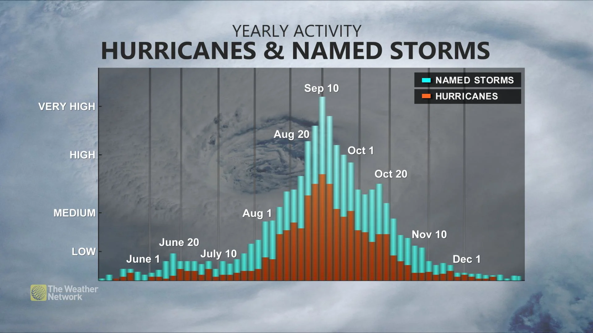
WHY DOES ACTIVITY PICK UP IN SEPTEMBER?
We typically see more frequent tropical systems, with greater lifespans and greater intensity, in September due to a few factors.
By this time of year, we have encountered peak summer heating, and the oceans are typically warmer than early months in the season. Warmer waters fuel tropical systems, allowing excessive rising motion over the water, resulting in strong thunderstorms that can become organized into tropical systems.
Another factor that comes into play is that we typically have less wind shear in the pattern this time of year. The Jet Stream is weaker in the summer months and wind shear fades through June and July, becoming almost non-existent in August and September. This is not a good thing, as wind shear can help weaken tropical systems.
When forecasters warn of an "above average" season, they are talking purely in terms of expected named storms, and none of these predictions typically make any claims to the expected severity of the storms. Indeed, so far the 2020 season has only produced one major hurricane -- that is, Category 3 or higher -- in the form of Hurricane Laura, which reached Category 4 prior to impacting the U.S. Gulf Coast with extreme winds and major storm surge last month.