
PHOTOS: The Prairies endure multiple days of severe storms, tornado threats

--
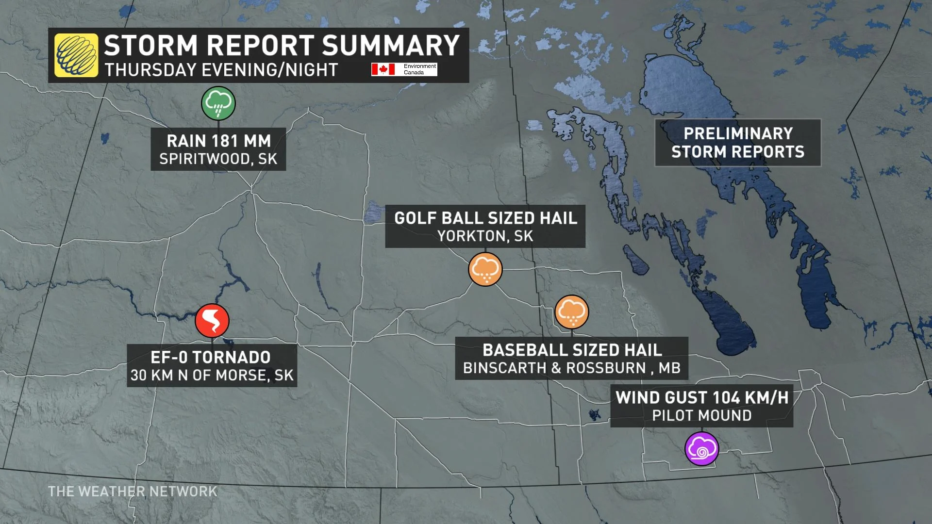
This week was rather storm-filled across the Prairies, with multiple days of severe thunderstorms that prompted tornado watches and warnings across Saskatchewan, Manitoba and northwestern Ontario.
While there were several reports of tornadoes this week, two have been confirmed from storms in Saskatchewan. On the evening of Thursday, June 23, a severe thunderstorm moved north of Morse, Sask., toward Central Butte. Environment and Climate Change Canada (ECCC) received reports of a tornado near Morse at approximately 5:40 p.m. local time.
The Northern Tornadoes Project (NTP) and ECCC collaborated on the tornado confirmation and will continue to gather evidence to document the track and intensity of the tornado. The included rating of the tornado's strength is preliminary and subject to change if more information becomes available.
The twister occurred 30 km north of Morse, but there were no reports of damage so far, so the it was given a preliminary default rating of EF-0. The storms also led to reports of golf ball-sized hail in Yorkton, Sask., as well as rainfall amounts of 181 mm in Spirtwood.
As well, there was a tornado in southwestern Saskatchewan Monday, just north of the hamlet of Rheinfeld at around 5:40 p.m. CST. That's the location of the Centennial wind farm. It was also given an EF-0 rating.
Severe thunderstorms also tracked into parts of southern Manitoba Thursday, eliciting tornado warnings for some areas Thursday, though none have been confirmed at this time. However, there was baseball-sized hail reported in Binscarth and Rossburn, Man.

Taken in Binscarth, Man. (@KarenTookTK/Twitter)
Also on Thursday, heavy rain and thunderstorms moved through Alberta as a low-pressure system tracked through the province.
Yet another round of severe thunderstorms targeted the eastern Prairies during the day on Friday, bringing large hail, heavy rain, and localized flooding to parts of southern Manitoba.
A slow-moving squall line developed south of the border and gradually filled into southern Manitoba and northwestern Ontario through Friday evening, prompting tornado watches for parts of the latter. These slow-moving storms continued through into the wee hours on Saturday.
Intense rainfall rates were reported in some thunderstorms in Manitoba, with 100 mm received in Carlowrie in a single hour, 52.9 mm received at the Winnipeg airport also in one hour, and 50 mm of rain reported at St. Joseph in 30 minutes.
As of 10 p.m. local time Friday night, Carlowrie had received 100 mm of rainfall, 69 mm observed in Dominion City, 59 mm documented in Rosa, 54 mm at Winnipeg airport and 50 mm in St. Joseph, among other locales.
Here's a look at some of the storms that have swept across the Prairies this week:
Thumbnail courtesy of @KarenTookTK/Twitter, taken in Binscarth, Man.


