
Ontario: Last chance at 20C this year before looming snow threat

Sunday will round out a gorgeous fall weekend, and Monday may very well be 2019's last 20°C day for Ontario.
Sunday looks set for another round of gorgeous fall weather, and it leads into a workweek that's set to begin with 20ºC daytime highs for some, likely our last shot at 20-degree weather for the year. But it will be a different story by the middle of the new workweek, as temperatures tumble in a cool down that threatens snow before Halloween. We take a look at who has the best shot to top 20 degrees, and who may be seeing snowflakes fly in the week ahead, below.
Visit our Complete Guide to Fall 2019 for an in-depth look at the Fall Forecast, tips to plan for it and a sneak peek at the winter ahead
WEATHER HIGHLIGHTS:
Temperatures continue to climb, with gorgeous conditions on Sunday
Rainy system moves in by Monday evening
Potential for late month pre-Halloween snow as a colder pattern locks in over the Great Lakes
Stay on top of the ALERTS in your area
LAST CHANCE FOR 20 DEGREES?
A surge of air from the south will make the morning chill a distant memory for most by the afternoon, however, with highs in the upper teens once again expected across much of the region.
That surge of air comes ahead of a developing system that will put an end to the stretch of sunny days, but will also bring a chance of 20-degree daytime highs, with Niagara the most likely to reach that threshold (onshore winds will keep the GTA a bit cooler, but still above-seasonal).
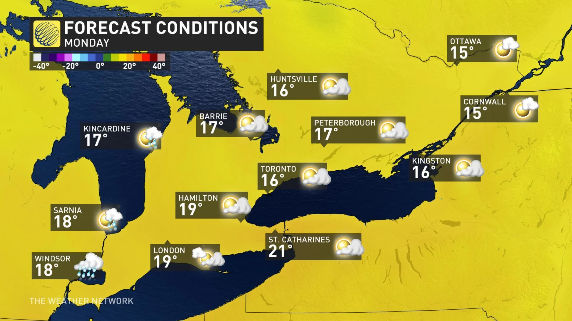
Should that system move in slightly slower, it would mean a more extended period of early-day sunshine, giving much of southwestern Ontario and the Niagara Peninsula more of a chance to top the 20-degree mark. Should it move in a bit faster, the result will be showers into the southwest for the afternoon, putting a cap on climbing temperatures.
NEXT FALL STORM TAKES AIM EARLY WEEK, THREAT OF PRE-HALLOWEEN SNOW
Whether we top 20 or not, the system will bring periods of heavy rain to the province between late Monday and Tuesday, with the core of the system set to linger over northwestern Ontario through Thursday.
The system will bring substantial amounts to parts of the south, as much as 50 mm for parts of east-central Ontario, though still substantial elsewhere.
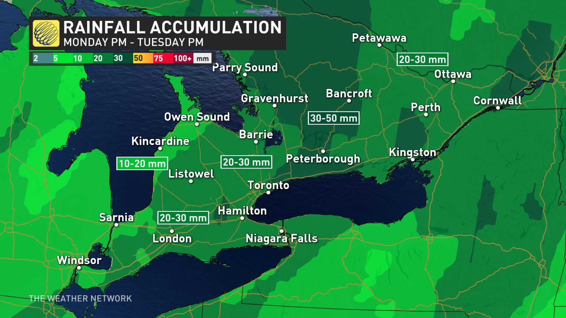
While conditions should remain warm enough across the province that this storm will initially bring rain, rather than snow, it will also bring strong winds as it moves through.
WATCH BELOW: TRACKING THE NEXT FALL STORM FOR ONTARIO
Those chilly west-northwest winds bring the risk for some lake-effect snow by mid-week for cottage country and east of Lake Superior. While no snow is expected further south, and southern Ontario will remain relatively mild until the end of the week, it won't escape the inevitable return of colder air.
"The final week of October and into early November will bring an extended period of colder than normal weather to the Great Lakes region, including southern Ontario," Gillham adds. "This pattern will bring the potential for lake-effect snow in the snow belt areas before Halloween."
Be sure to check back as we continue to track this first potential snow event.