Ontario: Hot, sticky weekend with widespread thunderstorm risk

Building heat and humidity fuels a widespread thunderstorm threat for the weekend.
The break in humidity will end across southern Ontario this weekend as those comfortable conditions will soon be replaced with the rising heat, and potentially, the warmest temperatures of the month so far. Thunderstorms are also possible throughout the weekend with the southwest seeing the potential for severe storms including heavy rain and small hail on Saturday morning. Details on the timing of these storms and a look at how high temperatures will soar, below.
WEATHER HIGHLIGHTS
Heat and humidity return for the weekend and possibly into next week
Isolated showers and thunderstorms expected on Saturday
Stay up to date on ALERTS in your area
WATCH BELOW: TIMING OF RAIN THIS WEEKEND
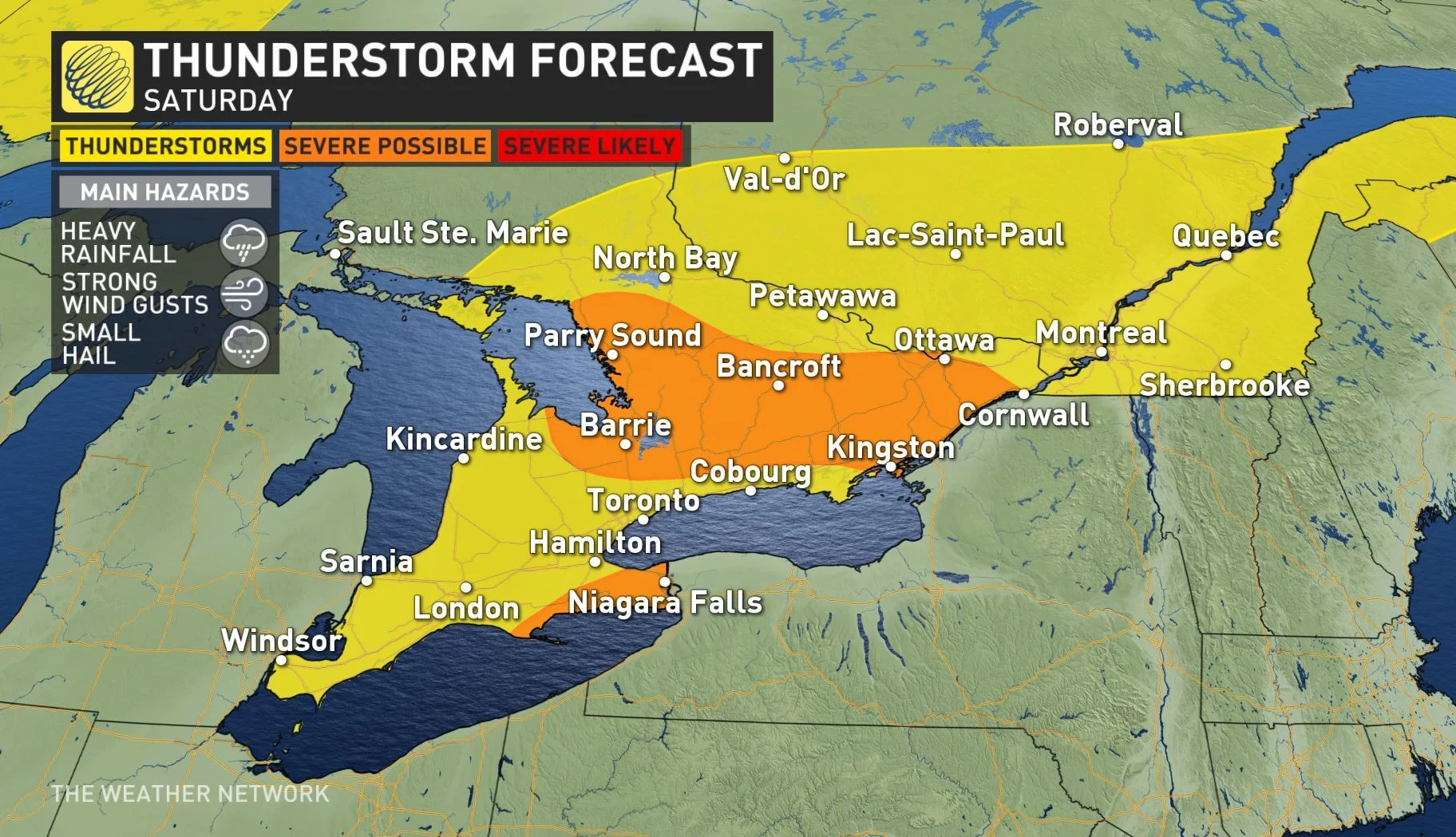
Saturday will begin with a widespread risk for thunderstorms that will later shift towards the eastern regions of the province by the afternoon hours.
"Saturday will be warm and very humid, but we also have a significant threat for a period of rain showers and thunderstorms," says Weather Network meteorologist Dr. Doug Gillham. "The threat for rain will be the highest during the morning hours and through the early afternoon."
The main hazards within these storms includes heavy rainfall, powerful wind gusts, and the potential for small hail.

The thunderstorms will be isolated across southern Ontario during the afternoon hours and most of the region will likely be dry for the second half of the day.
The storm risk area then shifts into eastern Ontario and southern Quebec, where the potential for severe thunderstorms is at its highest there. Powerful wind gusts would be the greatest risk with these storms if they develop in the east.
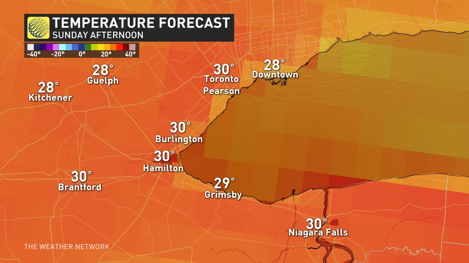
"Sunday will be the hotter day with high temperatures reaching and possibly exceeding 30°C with a humidex in the upper 30s to near 40," says Gillham.
There's also a higher threat for thunderstorms both early and late in the day, with a severe risk most probable to the north and west of the GTA and into eastern Ontario.
"Any storms the develop will produce torrential downpours and gusty winds," Gillham warns.
THE FIRST 30°C DAY OF THE MONTH?
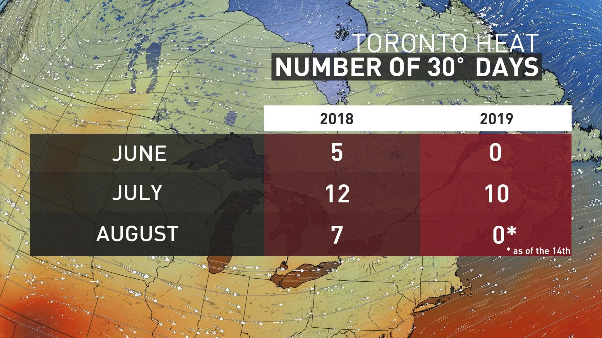
The building heat and humidity into the weekend means places like Toronto could finally see the first 30°C of the entire month.
So far, daytime highs have not hit the 30 degree threshold in the city, marking quite the contrast from the same time period last year when seven 30°C days had already been recorded by August 15.
The average number of days with a maximum temperature above 30°C in August is around 4.1, as recorded at Toronto's Pearson Airport.
FLIP FLOPPING TEMPS TO ROUND OUT AUGUST
The mid-summer heat is expected to spread into next week as well as temperatures soar to the upper 20s and lower 30s with humidity actually making things feel like the upper 30s to lower 40s.
A cold front however, will send temperatures tumbling to some of the coolest weather we've seen since early June by Thursday and Friday.
"High temperatures will only reach 20 to 22°C across our region, however, the cool down will be brief, with warmer weather expected to return for next weekend," Gillham adds.