Ontario: Widespread rain ahead of huge temperature plunge

After a rainy, spring-like start to the week, winter resumes quickly in southern Ontario.
The blast of milder December air that marked the end of the weekend in southern Ontario will linger nicely into Monday, but that warmth will be marred by a system that'll make the start of the workweek rather soggy for the region. That's as heavy snow and freezing rain spreads across northern parts of the province through Tuesday. The "equalizer" will begin on Tuesday afternoon as the cold air plunges southwards and puts much of the province into a much more wintry feel. More on the timing of the rain and snow to start the week, plus at look at when temperatures recover to above seasonal, below.
WEATHER HIGHLIGHTS:
Widespread rain showers hit southern Ontario Monday as temperatures remain mild for one more day
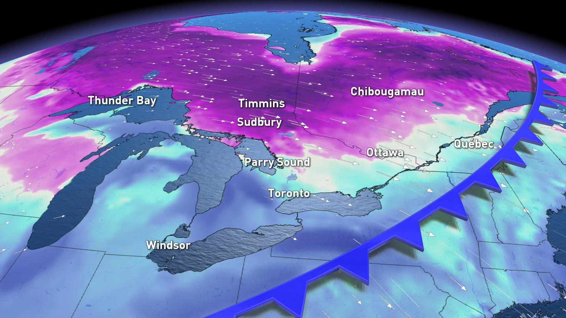
Prolonged freezing rain possible through northeastern Ontario, with large swath of heavy snow in the north
Snow squalls develop behind the system as much colder air floods the region
Stay up-to-date on the ALERTS in your area
MONDAY -- WIDESPREAD RAIN IN THE SOUTH
Much of southern Ontario can expect well above-zero temperatures for Monday, but those milder conditions -- with daytime highs peaking near the double digits -- will also be accompanied by a widespread rain that will persist for most of the day.
The heaviest rain from this system is set to fall in the early afternoon, lasting into the pre-dawn hours of Tuesday before tapering off through the morning. In terms of accumulations, it's looking like a fairly even spread across most of the south.

Complicating matters, Monday evening temperatures will remain slightly above freezing, adding up to a fair amount of melting snow runoff and pooling water.
MONDAY AFTERNOON, THROUGH TUESDAY -- PROLONGED FREEZING RAIN, SNOW IN THE NORTH
Due to the cooler temperatures over the north, between 10 to 20 cm of wet snow is expected through Tuesday morning for some places.

There will be a boundary between above and below-zero temperatures running through the Nickel Belt for the duration of this event, meaning people in those areas are threatened with several hours of freezing rain. The freezing rain will change to all snow by late Monday night as colder air funnels in behind the system, dropping temperatures as it surges south.
This much colder air from the northwest also raises the concern for a flash freeze across the north, as temperatures quickly plummet well below zero, freezing any precipitation that has fallen.
"Motorists should be prepared for poor winter driving conditions tonight as much colder air arrives and temperatures plunge to well below freezing," Environment Canada warns.
TUESDAY AFTERNOON, THROUGH WEDNESDAY -- SNOW SQUALLS DEVELOP AS COLD AIR FLOODS IN
The much colder air and gusty northwest winds will also contribute to the development of heavy lake-effect snow once again in the snowbelt regions through Tuesday.
Wednesday will also be blustery and cold with flurries and lake-effect snow squalls continuining.
"Early in the day, a southwest wind will cause the squalls to track across southern parts of the Niagara region and across the 401 well east of the GTA," says Weather Network meteorologist Dr. Doug Gillham. "During the day, the wind will turn to the northwest and the squalls will shift south and out of our region, however, squalls of Lake Huron and Georgian Bay will impact travel well north of Toronto."
Daytime highs on Wednesday will also be early in the day, and will continue to fall throughout the day.
FRIDAY -- SQUALLS EASE, TEMPERATURES RECOVER
The bands of lake-effect snow will finally weaken through the day on Thursday as temperatures bump up back above seasonal into the weekend and the start of next week.
"A significant system is expected to track towards the Great Lakes region during the weekend, but this will bring rain to the Golden Horseshoe once again," Gillham says.
CHRISTMAS OUTLOOK STILL UNCERTAIN
The weather pattern leading up to Christmas looks to remain changeable, with no sustained cold weather in sight.
"But there still will be the potential for wintry weather at times," Gillham adds.
Read more on the 'wild card' month of December, here