
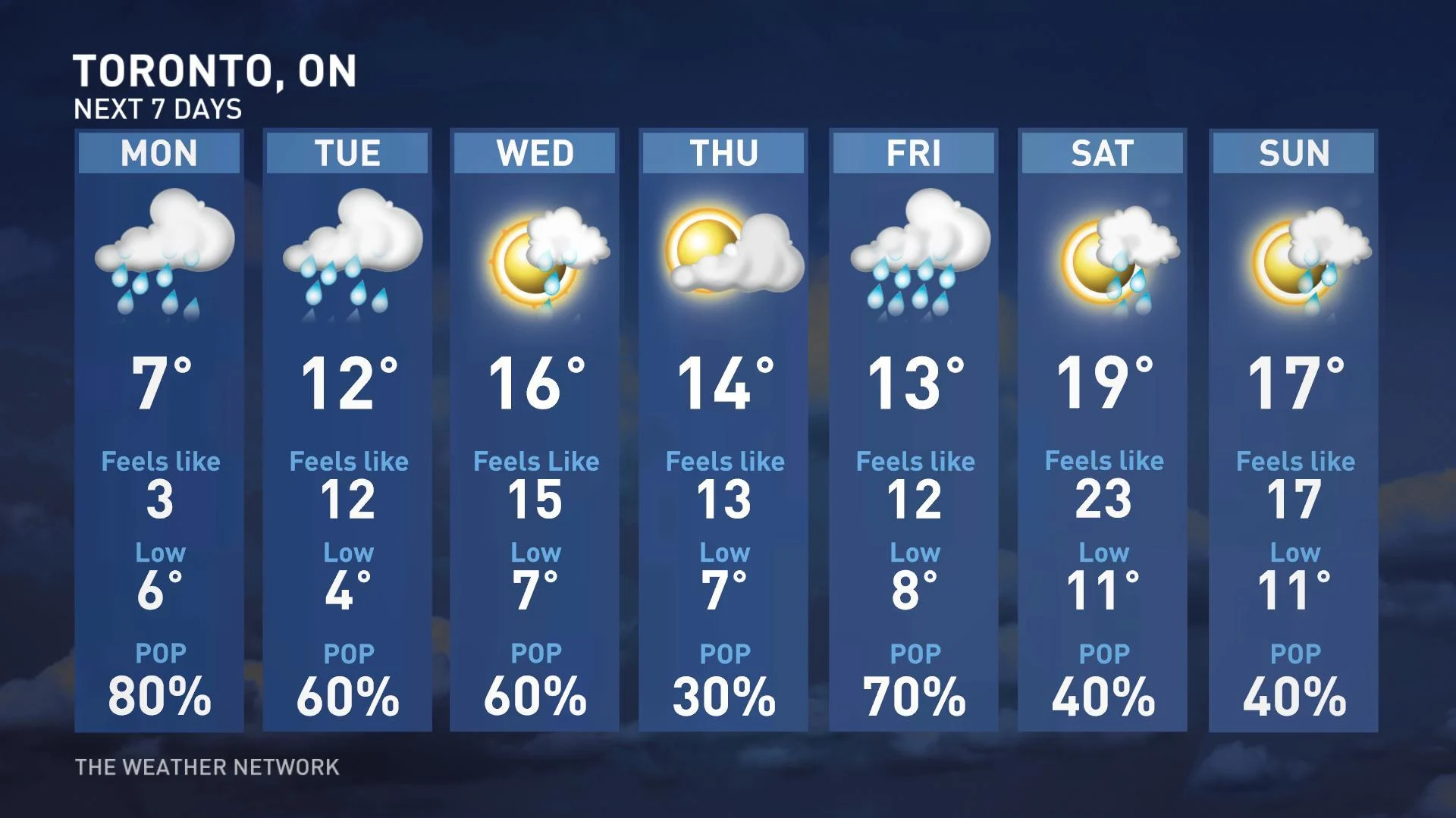
Ontario: Widespread rain, risk of snow on Monday

There is a risk for snowflakes Monday morning for some parts of southern Ontario, as temperatures remain below seasonal
The start to the work week will be wet and cold for southern Ontario as rain will continue Monday.
There is even the risk for snowflakes Monday morning for Dundalk Highlands, due to below-seasonal temperatures. It doesn't appear the chilly temperatures are going away anytime soon.
For timing of this wet system and a look at the forecast for the beginning of the week, read below.
Visit our Complete Guide to Spring 2019 for an in depth look at the Spring Forecast, tips to plan for it and much more
WEATHER HIGHLIGHTS
Rain continues overnight and into Monday
Snowfall risk Monday morning for Dundalk Highlands
Temperatures to remain seasonal or below seasonal throughout week
Latest watches and warnings HERE
WATCH BELOW:OVER A WEEK OF DAYS IN WINTER WARMER THAN MONDAY, WILD STAT HERE
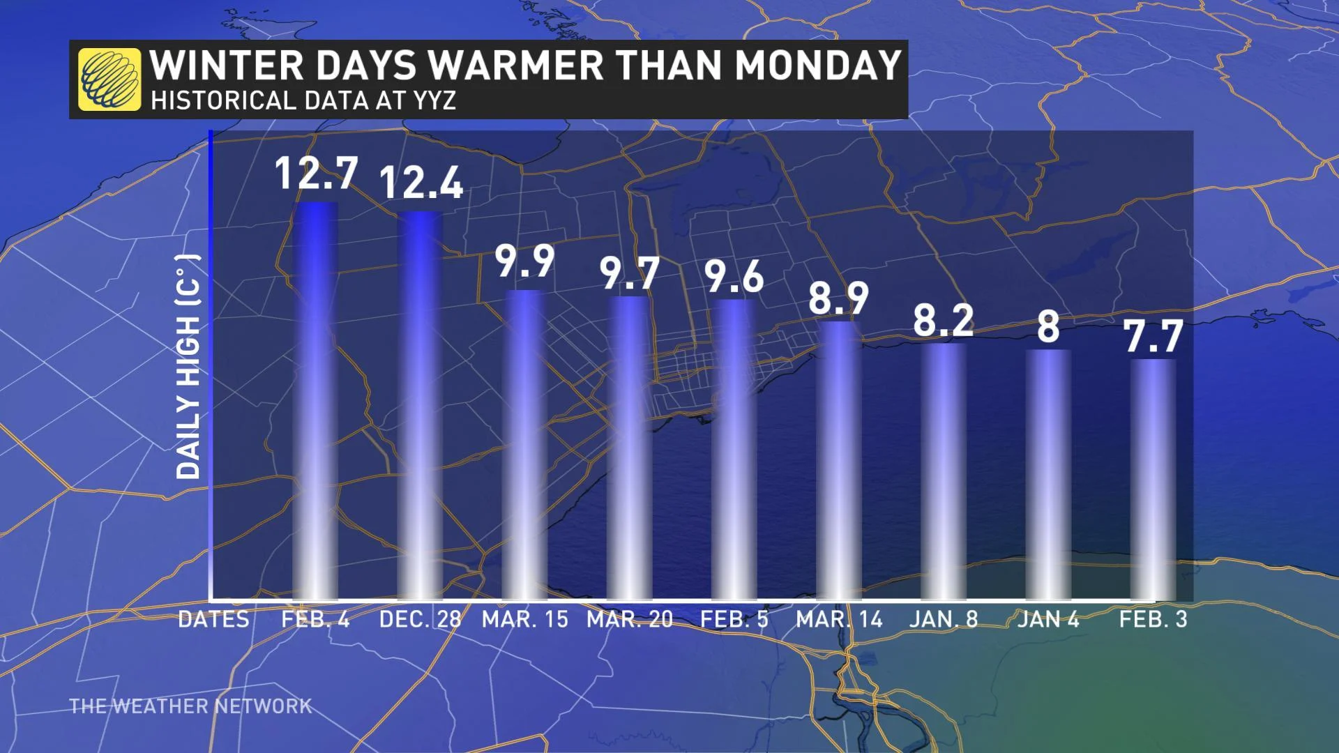
Weather Network meteorologist Tyler Hamilton says there were nine days in winter in Toronto that were warmer than Monday's forecasted high of 7°C, which is quite uncommon this late into the season.
WATCH BELOW: RAINFALL TIMING
The low pressure system that brought periods of rain to southern Ontario Sunday continues overnight and into Monday, reaching Ottawa by Monday morning.
Below-seasonal temperatures are widespread across southern Ontario, thanks to easterly winds blowing across Lake Ontario and Lake Erie.
WATCH BELOW: SIGNIFICANT CONTRAST IN ONTARIO TEMPERATURES
Most of southern Ontario is typically around 16°C at this time of year, but Windsor through east of the GTA will be up to 10 degrees below seasonal. Meanwhile northern Ontario will enjoy temperatures that are closer to seasonal on Monday and will be 10°C warmer than the GTA.
Although winds won't be as widespread as they were Sunday, there will still be gusts of 40-50 km/h along the shores of lakes Ontario and Erie.
RELATED: Watch? Warning? See what you need to know about the difference
WIDESPREAD RAIN MONDAY
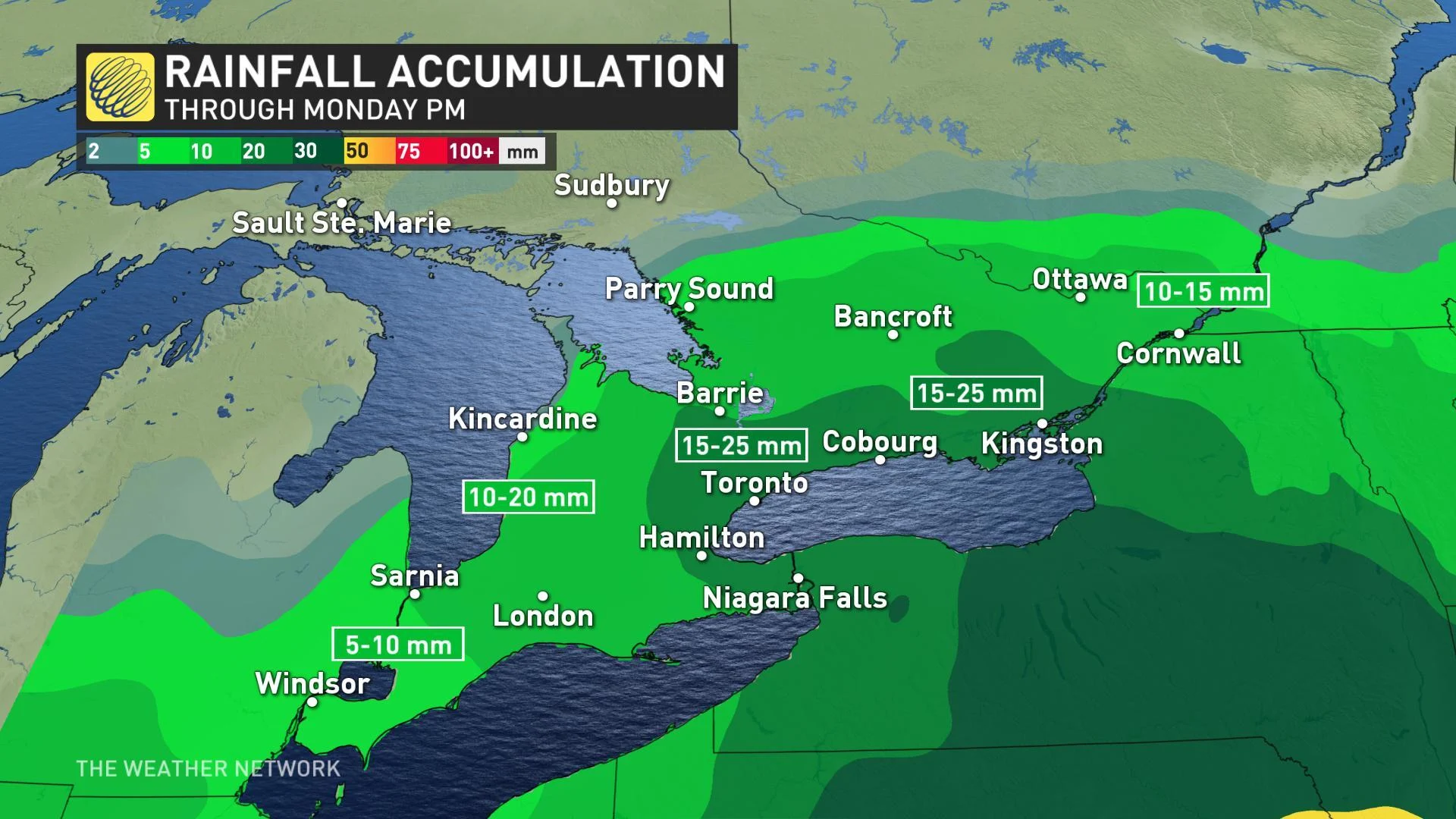
Sunday's showers will continue overnight and into the day on Monday, with Hamilton through Toronto to Barrie and Oshawa to east of Kingston seeing the potential for 15 to 25 mm. Surrounding areas seeing between 10 to 20 mm by Monday afternoon. Southwestern portions of the province will see 5 to 10 mm.
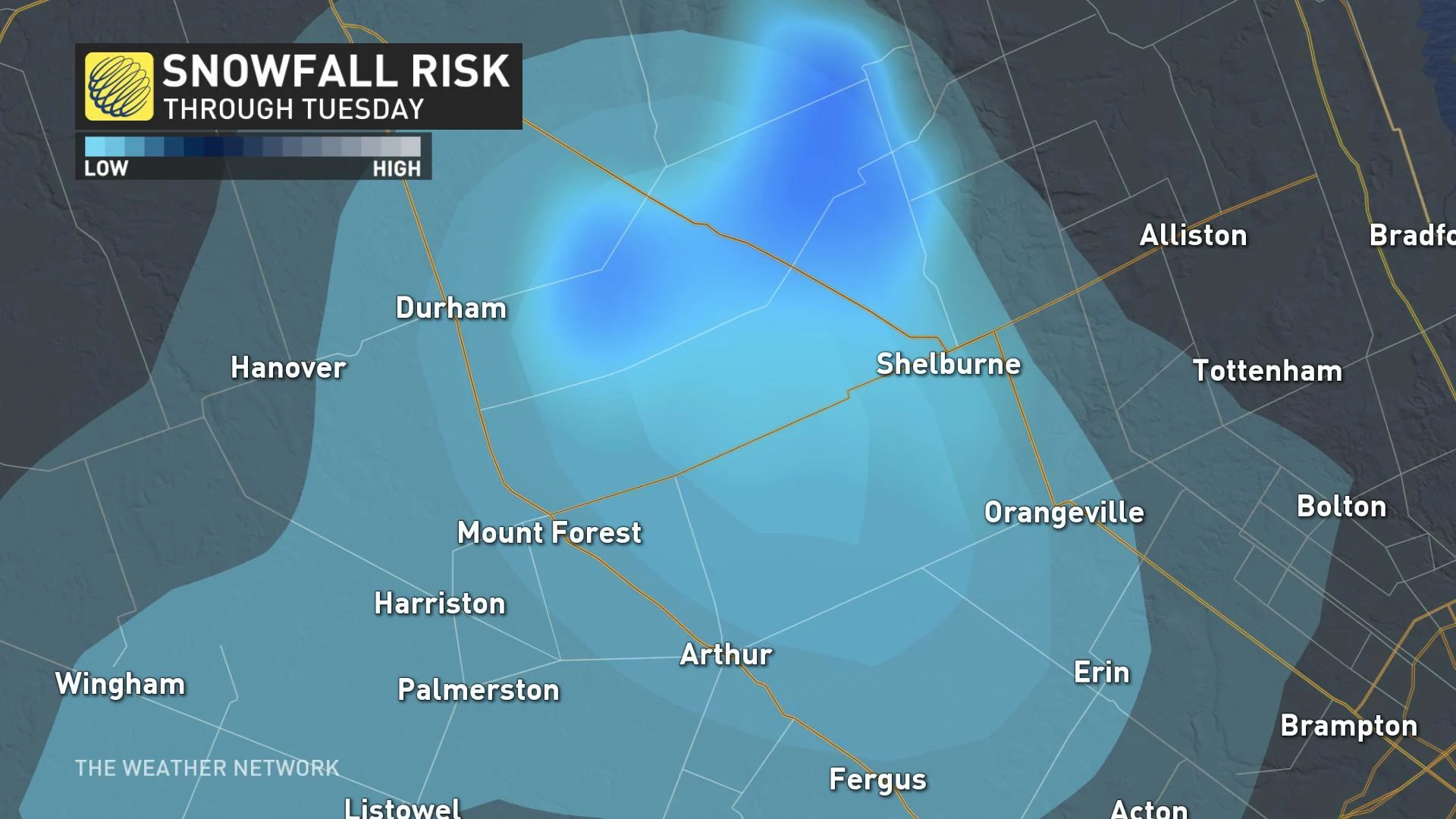
SNOWFALL RISK IN SOUTHERN ONTARIO
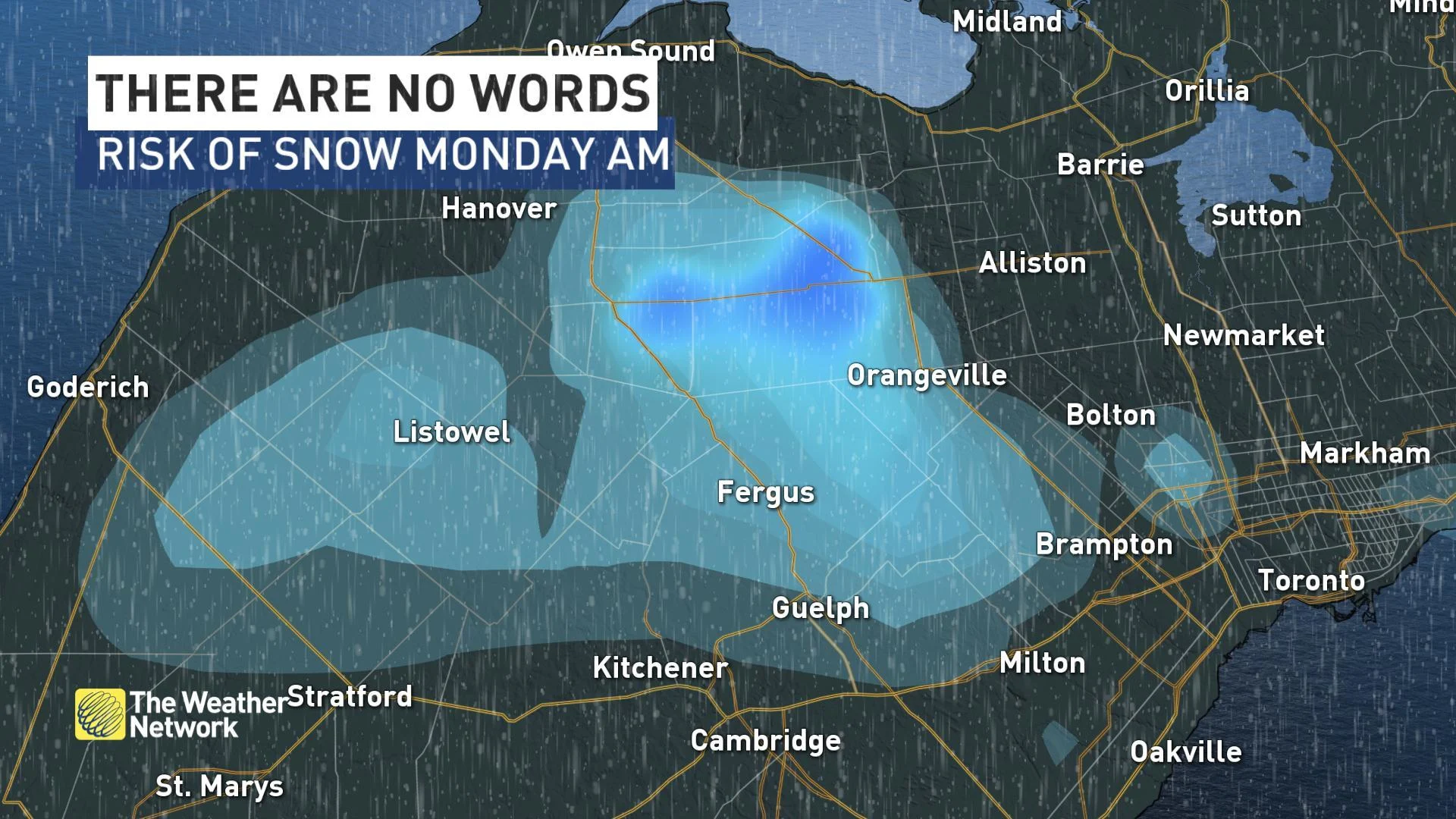
The chilly temperatures are creating the conditions for rain to transition to snow for some regions including Durham, Shelburne and Mount Forest.
While it won't likely accumulate once temperatures increase later on, it will certainly leave some feeling unimpressed with this spring season.
TEMPERATURES TO REMAIN SEASONAL OR BELOW SEASONAL THIS WEEK
Conditions are expected to improve through Tuesday as the low pressure system tracks eastward. Temperatures will continue to remain seasonal or be below throughout the week, with more chances for rain showers by the end of the week.
LAKE ONTARIO, ERIE FLOODING CONCERNS
Water levels in Lake Ontario have topped 75 metres and are currently sitting at 75.55 m -- about 30 cm shy of the severe flooding levels that swamped the Toronto Islands in 2017.
The body responsible for regulating flow from the lake -- the International Lake Ontario – St. Lawrence River Board -- expects water levels to continue rising until late May or early June, and puts the forecast peak somewhere between 75.65 to 75.95 metres. That would top 2017's record levels by about two centimetres.
"Water levels will continue to rise about a centimetre every single day," warns Weather Network meteorologist Tyler Hamilton.
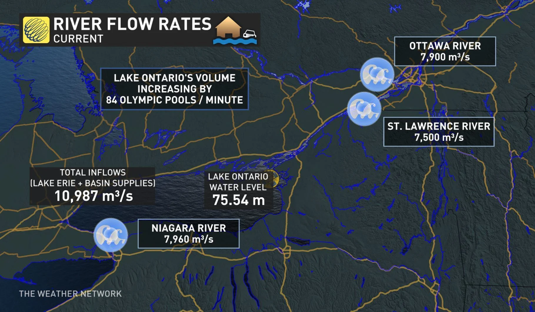
The shoreline hazard warning issued last week by the Toronto and Region Conservation Authority (TRCA) was renewed on May 7 and is set to remain in effect until further notice. The TRCA has also issued a notice of caution specifically for the Scarborough Bluffs due to the potential of landslides.
The Essex Region Conservation Authority has also issued a flood watch for shorelines along Lake Erie and the shores of Pelee Island. Officials say both Lake St. Clair and Lake Erie started the month with above record high water levels that were reached in 1986.
READ MORE: Toronto Islands face another year of significant flooding as lake waters rise