New burst of Pacific moisture slamming B.C. with heavy rain, and mountain snow

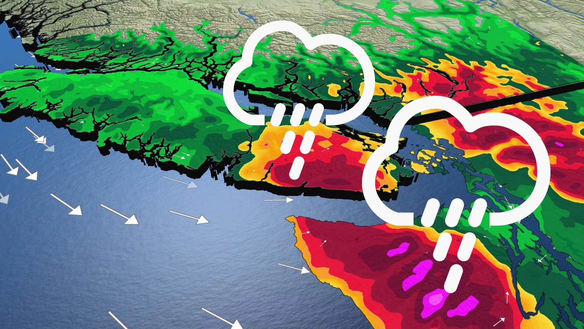
Yet more heavy rain and mountain snow were ramping up in B.C. Wednesday night, courtesy of the next soggy system in a parade of storms that have barrelled through in recent days.
B.C. barely had much time to dry out Wednesday, before the next burst of Pacific moisture began rolling into the province's Lower Mainland and Vancouver Island. Some areas are in line for 75-100 mm of rain through Thursday evening, with rainfall warnings in effect for Victoria, Metro Vancouver, and the Fraser Valley. In the mountain passes, a fresh dose of snow is also in the cards by Thursday morning. More on the timing and the impacts of this ongoing storm, below.
Visit our Complete Guide to Fall 2021 for an in-depth look at the Fall Forecast, tips to plan for it and much more!
INTO THURSDAY: NEXT SYSTEM IN RELENTLESS STORM PARADE SLAMS THE PROVINCE
The rain and alpine snow effects from Tuesday's system were scarcely in the rear-view mirror before the next one hove into view Wednesday, bringing its own impacts by the evening hours.
This is yet another moisture-laden system that will have people across the Lower Mainland and southern Vancouver Island waking up to a rainy morning. Parts of those regions, heaviest in the Fraser Valley and on the island, could see totals reach and even exceed 100 mm through Thursday, easing through the evening.
Vancouver itself and parts of Metro Vancouver are more in line for 20-40 mm, at the higher end the further up you go. Rainfall warnings are in effect for Vancouver Island, Victoria, and the Fraser Valley.
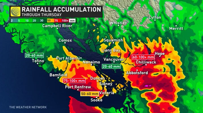
"Although it is unlikely that Victoria will see 50 mm of rain in a day, it happens in these setups, where the atmospheric river bypasses the Olympic Mountains. The mountains don't move, so the only thing changing is the wind direction. It looks to thread the needle between the Vancouver Island range and the Olympic mountains, creating heavier rain for Victoria," says Tyler Hamilton, a meteorologist at The Weather Network. "
Meanwhile, an unstable westerly flow has been bringing snow near the Coquihalla Summit through Wednesday, sometimes mixed to rain with rain. Another snowy night was ahead, with travel difficult into Thursday morning. The Coquihalla Pass will notch the highest totals, 10-20 cm, but most other passes will be in the 5-10 cm range.
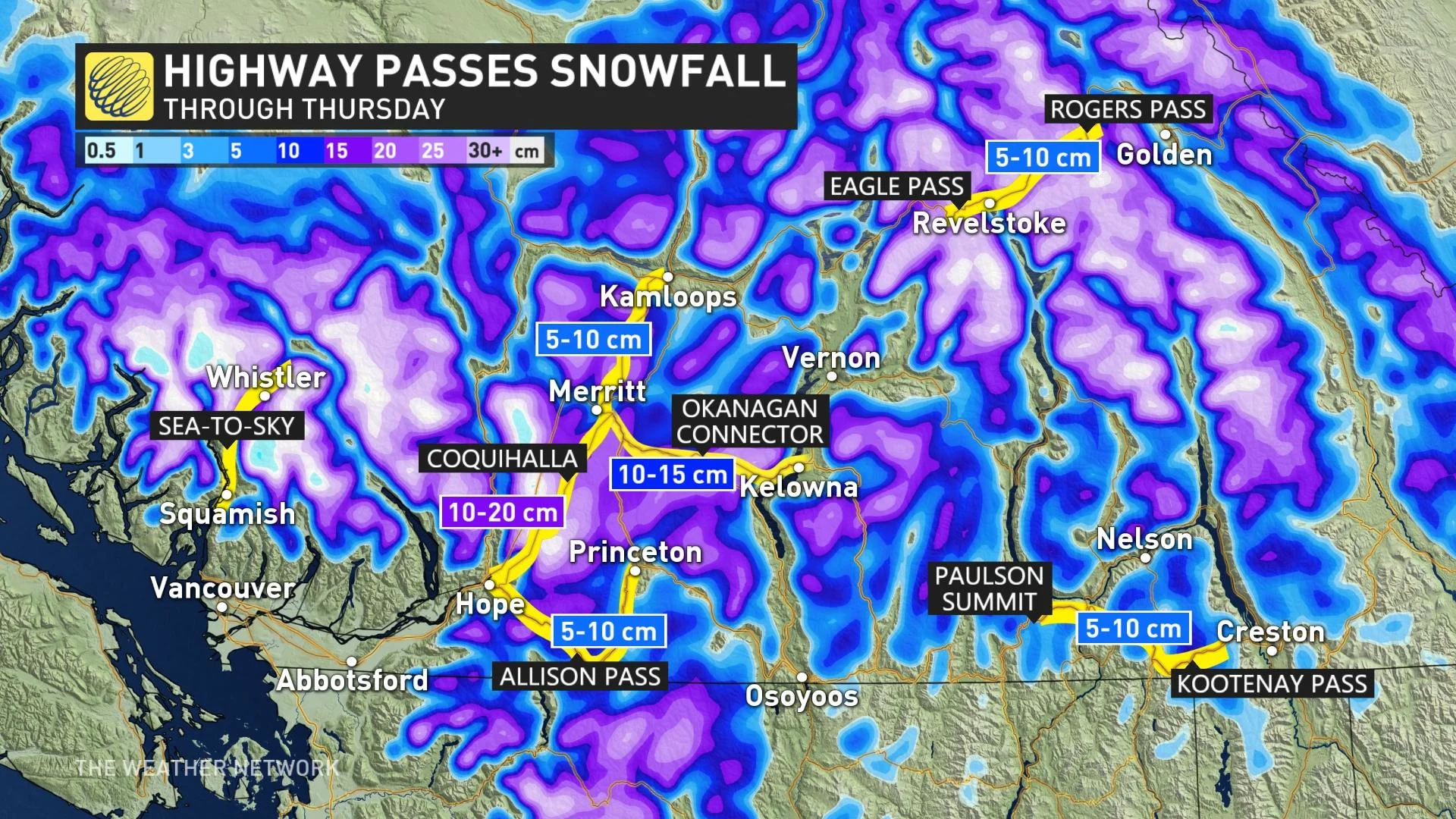
"Weather in the mountains can change suddenly resulting in hazardous driving conditions," Environment and Climate Change Canada (ECCC) says in the special weather statement for the Coquihalla Highway.
LOOK AHEAD: MUCH-NEEDED BREAK FROM THE STORMY PATTERN, UNUSUALLY PLEASANT HALLOWEEN
Beyond the next system, a much-needed break from the stormy pattern is expected -- with drier weather and sunshine late week and the weekend, lingering into next week. Abundant sunshine is in store this weekend for the South Coast, with unusually pleasant weather for Halloween.
Be sure to check back for the latest updates on the weather in B.C.