Nearly half of Canada's population hit by derecho, why it was harmful
Derechos of similar intensity have occurred before in this part of Canada, but never has one had a track like this that followed the length of the most densely populated corridor in the country.
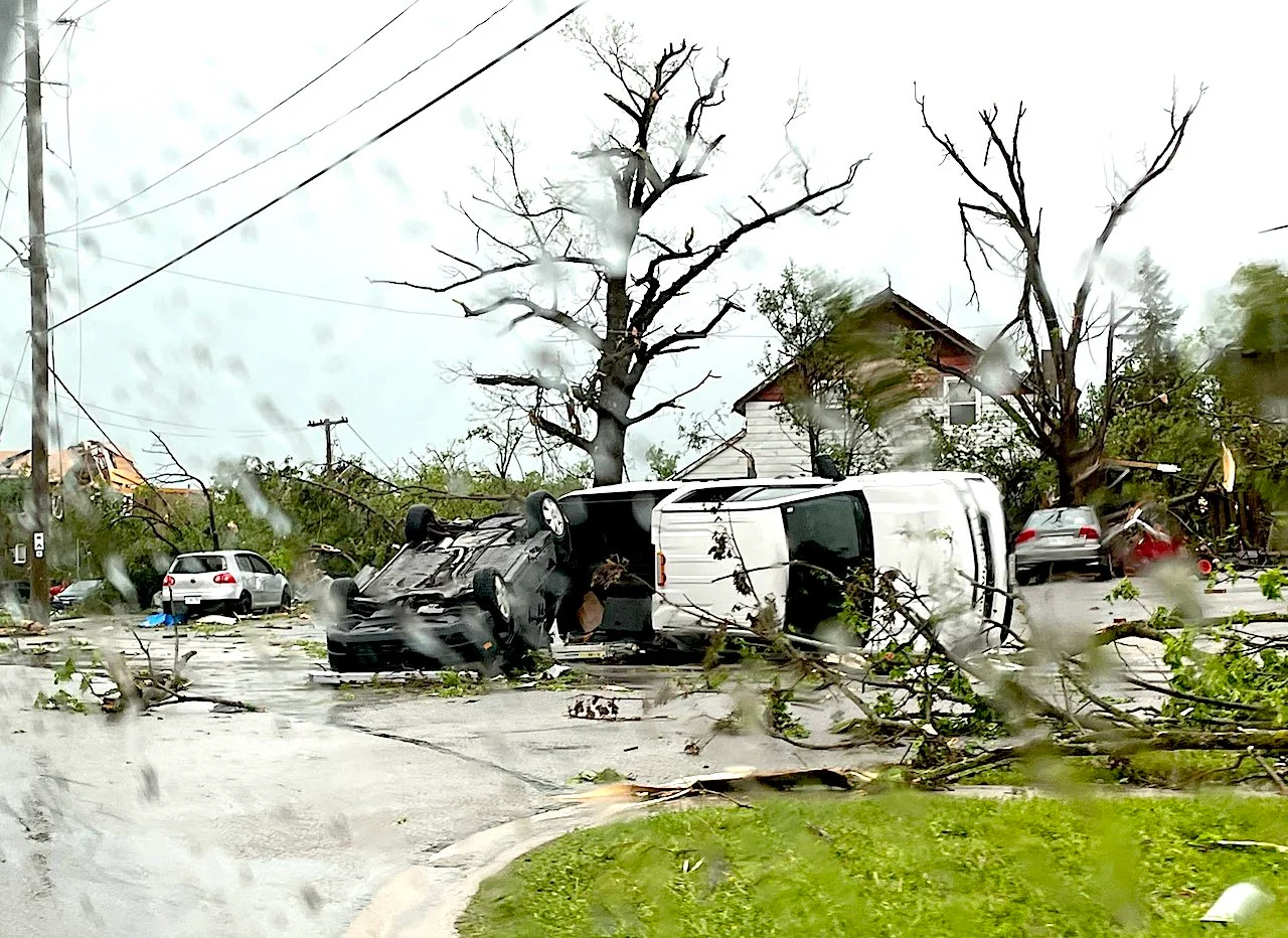
Saturday’s derecho was one of the most destructive and deadly wind events in Canada’s history.
Why? Unfortunately, all variables lined up in a way that maximized the loss and tragedy.
SEE ALSO: Derecho leaves roughly 1,000 km of damage, fatalities in its wake
HOW IT CAME TOGETHER
Timing: Had this exact same weather system happened on a weekday, casualties would likely have been lower. As it was, the derecho struck on what just minutes before had been a warm, sunny Saturday on the May long weekend. A high-impact weather event requires two ingredients: Extreme weather and a vulnerable population. The vulnerability for an event like this was about the highest it could possibly be with so many people outside.
Location: The track of this derecho could not have been drawn up any worse. The line of thunderstorms entered southwestern Ontario in the late morning hours, intensifying as it moved along the 401 corridor through the peak heat of the afternoon. It then continued across eastern Ontario into the Laurentian Mountains in southern Quebec.
Derechos of similar intensity have occurred before in this part of Canada, but never has one had a track like this that followed the length of the most densely populated corridor in the country.
The storm: Derechos are special classes of damaging thunderstorm squall lines, remarkable for the large area they impact. The term derecho is Spanish for "straight ahead" as most of the associated wind damage is the result of straight-line winds that blast out of the storm, as opposed to tornadoes -- though they can occur with a derecho.
While forecasts indicated the potential for severe thunderstorms on Saturday, particularly for eastern Ontario and southern Quebec, there was no indication this day would produce an historic derecho event. A rather ordinary line of thunderstorms crossed the border from Michigan in the mid-morning.
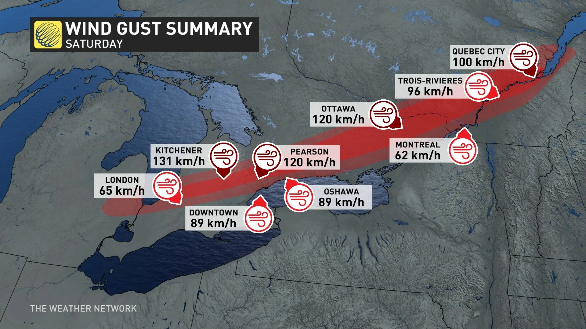
Rather than falling apart as morning storms often do, they intensified as they moved along the 401 corridor -- striking a delicate and destructive balance between the jet stream winds steering the system, and the warm, humid air that fuelled its advance. It wasn’t until later morning that the scale of the wind damage potential became more apparent.
The label of derecho wasn’t applied until after the bowing line of storms rolled into Quebec, when it was apparent that the intensity of wind gusts over the previous hours, coupled with the widespread swath of damage, would meet the naming criteria.
COMPARISON TO PAST DERECHOS
Derechos are among the most destructive weather events that Canada can experience. While the wind intensity cannot equal a strong to violent tornado, the expanse of area affected is orders of magnitude greater, often resulting in greater overall impact than tornado events.
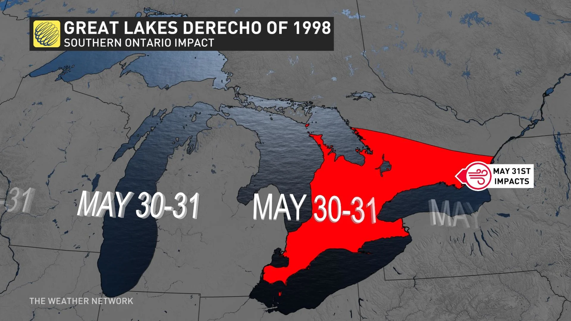
Saturday’s derecho was comparable in intensity to derechos of the 1990s that affected parts of Ontario. The most extreme damage from Saturday’s derecho appeared to be near Ottawa where multiple hydro transmission lines were toppled. This type of damage is usually only found in tornadoes, however, it has happened before with straight-line winds. On Aug. 2, 2006, transmission towers east of Georgian Bay were toppled due to a bowing line of storms that originally developed over northern Michigan before racing across Georgian Bay.
Are severe thunderstorms and derechos becoming more frequent and intense?
People in Ottawa, especially, are probably wondering about this. The scars of the September 2018 twisters hadn't fully healed when Saturday’s derecho brought widespread destruction to the Ottawa-Gatineau region. It’s difficult to discern trends on rare events like these. In general, there are no indications that severe thunderstorms, derechos or tornadoes are becoming more frequent or more intense in Canada.
However, the general northward trend in the summer jet stream due to global warming may be shifting the risk of these events farther north. A recent study by the Northern Tornadoes Project found that significant tornadoes are occurring later in the year.
It’s tempting to say because this derecho happened in May that this is a sign of earlier and more destructive severe weather. However, one of the most destructive derechos on record occurred on May 31, 1998 -- affecting Wisconsin, Michigan and southern Ontario.
Additionally, Ontario has not experienced a violent tornado (rated EF-4 or 5) since May 31, 1985. There were three violent tornado events from 1979-1985, but none since then. Certain threats like heat waves and heavy rainfall are increasing, but the trends regarding severe thunderstorms, derechos and tornadoes are far from clearcut.
Thumbnail courtesy of Carrie Chisholm/Twitter.