Rising temperatures and strong winds picking up across Ontario

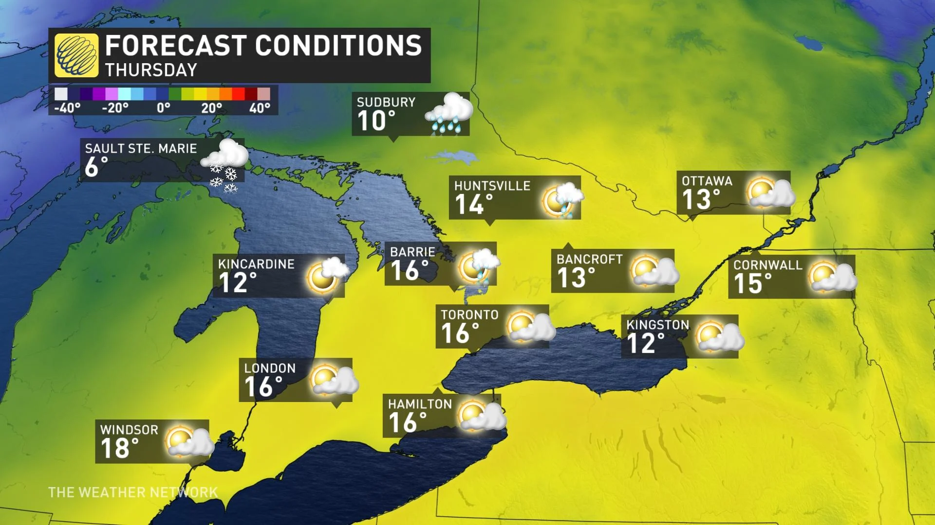
Another influx of mild air will send temperatures into the mid-teens in southern Ontario Thursday, but keep the shovels handy, as snow returns as early as this weekend.
While the impacts won't be as potent as last weekend's damaging wind storm, Thursday's winds will still be something to prepare for, with gusts as high as 90 km/h lingering through the day. The upside will be strong southerly flow bringing in another surge of warmth and possibly record setting daytime highs. Beyond, temperatures dip once again, and the weekend looks to start off with some snow, significant for some places. For a closer look at what to expect, see below.
Visit our Complete Guide to Winter 2022 for an in-depth look at the Winter Forecast, tips to plan for it, and much more!
THURSDAY: MESSY, WINDY SYSTEM MOVES IN, TEMPERATURES REACH DOUBLE-DIGIT HIGHS
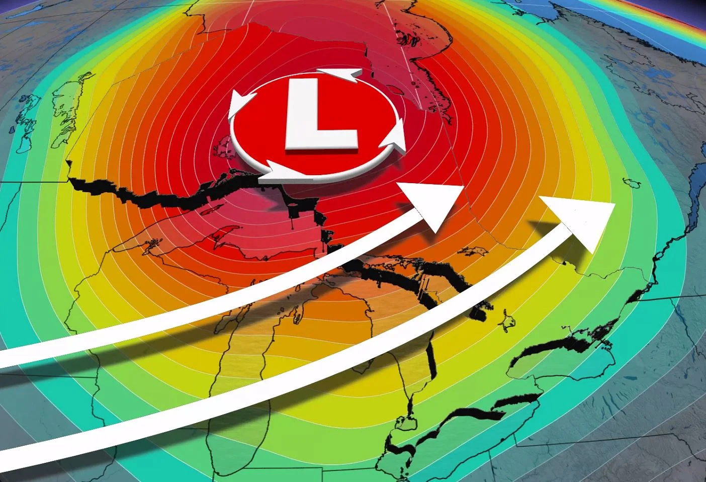
A warm front associated with a Colorado low was already bringing warm temperatures Wednesday evening, and daytime highs look to peak Thursday in the mid-teens once more. Though Wednesday carried some freezing rain risk Wednesday night, it'll be long gone by the morning.
In fact, there will once again be the chance for Toronto to set a new daily record with these well above seasonal conditions. In fact, the daytime high in Toronto may actually be warmer than that of Los Angeles, which is forecast to sit around 12°C for Thursday.
However, the system's winds were ramping up Wednesday evening, likely peaking in the 70-90 km/h range, and remaining gusty before easing Thursday.
The highest gusts are expected along the shores of Lake Huron, with wind warnings in effect for those areas Wednesday evening. Local power outages are possible, though the impact presently doesn't look to be as severe as this past weekend's system.
The centre of this low pressure system will be tracking into far northern Ontario through Thursday, where most of the rain, freezing rain and heavy snow will be confined.
As much as 20 cm of snow threatens the hardest-hit places, as the rain continues to transition over to snow across the north.

COOLER AIR RETURNS FOR THE WEEKEND, EYES ON THE WHITE CHRISTMAS CHANCES
A widespread cooldown arrives shortly after this brief surge of warmth, however. By the weekend, temperatures will fall back to seasonal or even a few degrees below that.
A system is set to track south of the border on Saturday, bringing wet snow across much of southern Ontario and Quebec.

While the pattern next week looks to be more seasonal, changeable conditions are still expected, with exact storm tracks being the key to a white Christmas.
"Ironically, the pattern evolution will be influenced by a typhoon in the western Pacific and the impact on the pattern will be to create more resistance to the advance of Arctic air into our region," says Dr. Doug Gillham, a meteorologist at The Weather Network. "However, it looks like we will see a rather wintry stretch between Christmas and New Year’s, and well into early January, as well."
Be sure to check back for the latest updates on the changeable pattern across Ontario.