More heavy snow, winds make for dangerous travel on the eastern Prairies

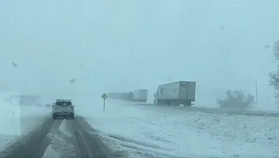
Blowing snow and icy conditions have made for treacherous travel across Saskatchewan, leading to widespread road closures and power outages.
A taste of early winter-like weather arrived across parts of the Prairies this past weekend, with heavy snow and strong winds leading to dangerous travel. Snowfall and winter storm warnings remain in effect across central Saskatchewan and northern Manitoba, with 10-20+ cm of snow possible in the hardest hit areas through Monday. Power outages and road closures have hit the region as a result of this potent early season storm. See more on the timing and impacts from the Colorado low, below.
First look: Pattern reversal expected as Canada falls into winter
Monday into Tuesday: Winter warnings remain in effect for potent Colorado low, dangerous travel
A pattern reversal across North America has allowed the season’s first Colorado low to develop and target the eastern Prairies. Heavy snow, rain, and gusty winds will continue to impact the area through Tuesday.
Colorado lows, which are systems that form over the Rockies near Colorado and track into northeastern Canada, are a mainstay of weather forecasts this time of year. These energetic systems often pester Canadians with foul weather as they move through.
RELATED: How Colorado lows and Texas lows affect your weather in Canada
Several roads and highways were closed across Saskatchewan on Sunday, including the Trans-Canada Highway from Regina through Moose Jaw, which remained closed early Monday morning, as well. That's as ice and snow covered the roads, along with gusty winds, which led to near-zero visibility.

The Moose Jaw Police Service also released a warning on Sunday, urging drivers to check the highway hotline before heading out.
"The Moose Jaw Police Service is currently dealing with a high-volume call load involving collisions, jack-knifed semi units and vehicles in the ditch on Highway #1 and within the city," the press release read. "Traffic has been stopped due to a pile up of vehicles and semis affecting the westbound lane from Regina to Moose Jaw."
Thousands of customers remained without power Monday morning, with the majority of the outages reported in Moose Jaw and surrounding areas.
"Snow and winds will continue to make for poor travel conditions across southern Saskatchewan and into western Manitoba through the day on Monday," says Kelly Sonnenburg, a meteorologist at The Weather Network. "Wind gusts of 40-60+ km/h in combination with freshly fallen snow will keep driving conditions poor and unpredictable."

Additional snowfall amounts of 5-10 cm of snow are forecast across southern Saskatchewan through Monday. Much higher snowfall amounts are forecast to fall across northern Manitoba, with up to 30 cm possible by the time all is said and done.
A winter storm warning is in effect for the region.
"Consider postponing non-essential travel until conditions improve," says Environment and Climate Change Canada in the warning. "Surfaces such as highways, roads, walkways and parking lots may become difficult to navigate due to accumulating snow. Prepare for quickly changing and deteriorating travel conditions."
PHOTOS: Major city hit with Canada's first hefty snowfall of the season
Meanwhile, rain showers and embedded thunderstorms will continue across southern Manitoba and into northwestern Ontario through the day, with an additional 10-30 mm of rain expected locally.
The rain, wind and snow will all ease into Tuesday morning, though with lake-effect snow squalls expected off the Manitoba lakes lingering through the day with isolated blustery conditions.
Stay tuned to The Weather Network for the latest forecast updates on this early season snowstorm.