
Surging warmth in Central Canada will come with complicated storm setup

This week will bring quite the temperature roller-coaster to much of southern Ontario and Quebec as frigid wind chills give way to some of the mildest conditions of the year. With that however, also comes the complication of an active storm track.
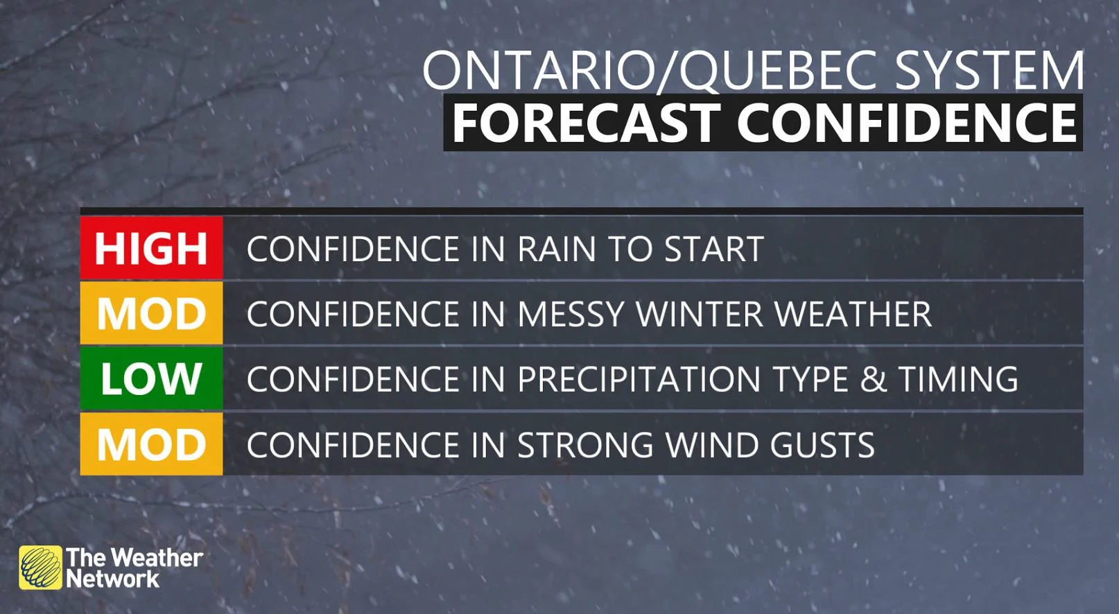
The bad and good news will alternate in Central Canada this week. The bad news is Tuesday will be another chilly day in Ontario and Quebec. The good news that unseasonable warmth will push into the provinces Wednesday, potentially leading to the highest temperatures of 2022 so far. But back to the bad news, there will be a complex storm setup as a result of Ontario and Quebec becoming the battleground between warm and cold air. The resulting storm threatens a messy mix of rain, snow and ice, as well as blustery winds, through Friday. The outcome may also lead to localized flooding. More on what we know so far and the possible challenges to commute times expected, below.
WEDNESDAY INTO THURSDAY: SOARING TEMPERATURES, STRONG WINDS SPELL TROUBLE FOR MESSY CONDITIONS
Tuesday will be the last day of frigid cold in Central Canada as a surge of mild air is set to push in with the formation of a boundary for mid-week.
On Wednesday, temperatures will soar well above freezing with a gusty southwest wind, as daytime highs rise into the high single digits. For some areas, this could actually be some of the warmest weather for 2022 so far.

While temperatures won't be quite as warm in southern Quebec, they will still remain above seasonal and hover above the freezing mark.
At the same time however, Arctic air will slowly start sliding south as a strong cold front crosses through, setting up a boundary over northern Ontario and Quebec first. This will be the beginning of a battleground of temperatures over the region, which will complicate the storm track and the precipitation types it brings.
DON’T MISS: Here's how to stock your vehicle's emergency kit, BEFORE you get stranded
Snow will begin to fall in northern Ontario Wednesday morning. Precipitation will then push into the lower Great Lakes for communities near Georgian Bay and Lake Huron in the evening, manifesting as rainfall that will then slide into the rest of southern Ontario in the overnight hours.

"While a large temperature contrast presents itself over the region on Thursday, an active storm boundary will bring in with it plenty of rain, ice and snow," says Kelly Sonnenburg, a meteorologist at The Weather Network. "And so depending what air mass you are situated under, will determine the precipitation type you will see."
The exact position and timing of the front is still uncertain, which will be the key to what areas will see primarily rain versus a more extended period of ice and snow.
As well, winds will be an issue. They will pick up in southern Ontario Wednesday morning, gusting to 50-70 km/h, strongest near the Lake Huron shores. They will then ramp up to 60-80 km/h in the afternoon, lingering overnight.
WATCH: LATE-WEEK FLOOD THREAT LOOMS FOR SOUTHERN ONTARIO
Regardless, this will make for a widespread messy Thursday and Friday across the south, as roads become icy with the plunging temperatures quickly freezing any standing water or slush. The system could also produce some localized flooding since the ground is still largely frozen.
The Arctic air will eventually overtake the milder conditions and flood the entire area with below seasonal temperatures again by Friday. A warming trend is expected throughout the weekend and into next week, possibly bringing multiple days of very mild, even spring-like weather.
Looking ahead further, we're watching the potential for a taste of early spring at the end of February and into the beginning of March for southern Ontario and Quebec. However, keep in mind it is highly unlikely we are completely finished with the winter weather just yet.
Subscribe to 'This Day in Weather History': Apple Podcasts | Amazon Alexa | Google Assistant | Spotify | Google Podcasts | iHeartRadio | Overcast'
Check back for the latest forecast across Ontario and Quebec.