Temperatures to plummet after hazardous snow squalls blast Ontario

Howling winds and lake-effect snow squalls will finally ease after bringing dangerous whiteout conditions Monday, causing accidents and prompting road closures.
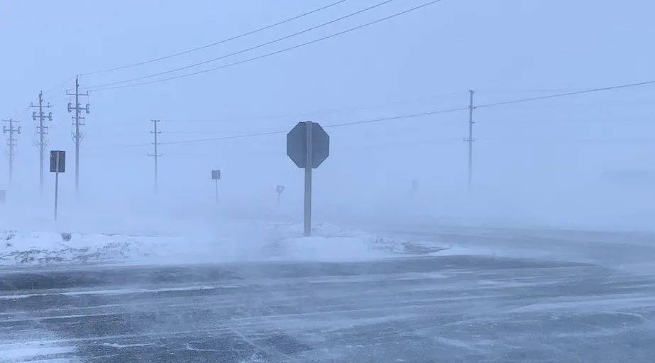
Powerful and dangerous snow squalls blasted parts of southern Ontario Monday, as an Arctic front was accompanied by intense northwesterly winds. This was the perfect setup for the potent squalls, which brought life-threatening conditions, resulting in sections of Highway 400 being shut down in the afternoon after a multi-vehicle pileup. Conditions will gradually improve early Tuesday morning as winds ease off. However, travel could remain tricky due to blowing snow. Behind the squalls will be a rush of frigid air, set to bring bitter overnight temperatures and wind chills. Temperatures will remain chilly on Tuesday but will be met with fair conditions for the most part. Light snows sweep across northern Ontario along a warm front in the afternoon, spilling into eastern areas by Tuesday evening. The good news is the temperatures will rebound significantly through mid-week, though with the typical late winter flip-flopping expected into the weekend. More on the timing and impact, below.
WEATHER HIGHLIGHTS
Snow squalls ease off Tuesday morning as winds relax
Frigid overnight lows forecast, wind chill near -20 for some through Tuesday AM
Temperatures majorly rebound on Wednesday
TUESDAY: CONDITIONS IMPROVE AS TEMPERATURES MAJORLY TUMBLE
The snow squalls brought treacherous travel conditions, leading to collisions and highway closures including Highway 400 north of Toronto Monday.
Ontario Provincial Police closed a stretch of the highway in the northbound and southbound lanes due to whiteout conditions that led to a crash involving 15 vehicles on Monday afternoon.
Visit our Complete Guide to Spring 2021 for tips to plan for everything ahead!
The good news is the powerful snow squalls, which even led to blizzard conditions in the Grey-Bruce region, will begin to subside through early Tuesday morning as winds ease. However, travel will continue to be difficult.
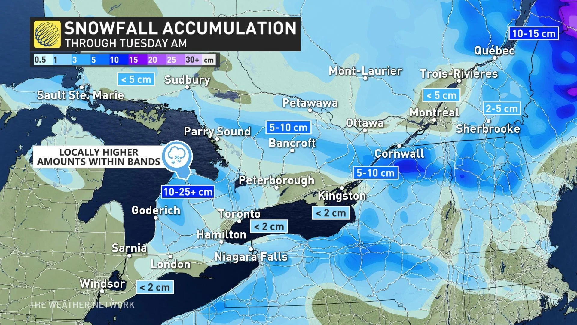
Through Tuesday morning, some areas could see local heavy snowfall amounts exceeding 20 cm, particularly in Grey-Bruce region. While Toronto and the GTA were briefly under snow squall warnings early Monday evening, minimal accumulations were expected.
To add insult to injury, temperatures will be dropping down to the minus teens through Tuesday morning, feeling closer to the -20s with the wind chill. They will be even colder in central and eastern areas, with temperatures plummeting close to -20°C, with wind chill values near -30.
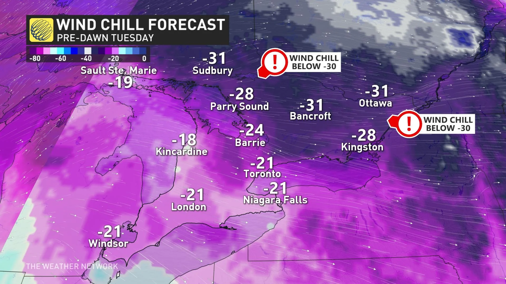
Frigid temperatures are expected to continue into Tuesday morning, with values still hovering around the minus double digits, especially for parts of eastern Ontario. On the plus side, fair skies will return, with the exception of a weak system traversing parts of northern and eastern Ontario throughout Tuesday – bringing periods of snowfall to the region.
SQUALLS BRING TREACHEROUS OVERNIGHT DRIVING TO SOUTHERN ONTARIO
LOOK AHEAD: TURNING MILDER BRIEFLY, BUT NO MAJOR STORMS IN SIGHT
Fair and mild for southern Ontario on Wednesday with mid-to-upper single digits. However, temperatures will get colder again late-week and into the weekend as the cool flow returns from the northwest.
Temperatures will be a few degrees cooler than seasonal for southern Ontario and well below seasonal for eastern areas. An extended period of relatively quiet weather – no major storms in sight. Watching the potential for a few days of much warmer weather mid-next week, especially for parts of southern Ontario away from the Great Lakes' chilly influence at this time of year.
Be sure to check back for the latest weather updates across Ontario.