Fisher River will recede within its banks by Monday, forecasters say
The swollen Fisher River should recede within its banks by Monday at Peguis First Nation and late next week further downstream, Manitoba's chief flood forecaster said on Thursday.
That offers some welcome news for First Nations communities dealing with what Manitoba's infrastructure minister says is the worst flooding since 1962 in the low-lying northern Interlake region.
Fisaha Unduche, the director of Manitoba's hydrologic forecast centre, said both the Fisher River and the Icelandic River further south should stop overflowing their banks by May 13 at all points down to Lake Winnipeg.
"River levels have peaked at most locations for Icelandic and Fisher River and will continue to drop accordingly," Unduche said at a news briefing along the Assiniboine River in Winnipeg.

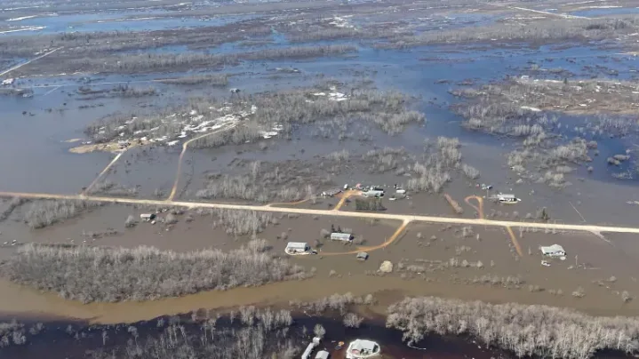
A Thursday photo shows flooding around Peguis First Nation in Manitoba. The Fisher River has spilled its banks at Peguis, flooding a broad area of Manitoba's low-lying northern Interlake region. (Jaison Empson/CBC)
He described the flooding on the Fisher River as a one-in-100-year event and warned standing water may remain well after the river itself recedes.
Unduche also downgraded the crest projection for most of the Red River, projecting the peak volume between St. Jean Baptiste and the Red River Floodway inlet will end up somewhere between the levels of the 2009 flood and the slightly less severe 2011 flood.
This is an improvement from last week, when he projected the Red would flood at or near 2009 levels.
That forecast remains for the Red between Emerson and Letellier, but not further north, where the river channel widens out, Unduche said.
As of Thursday, the Red River's flow was 78,200 cubic feet per second at the floodway inlet. The 2009 flood crested at the inlet at 97,000 cubic feet per second.
The slightly improved forecast for the northern portion of the Red River led the City of Winnipeg to hold off on plans to ensure 16 low-lying properties within the city are protected by sandbag dikes.
"Based on the latest provincial forecast, and our own data analysis and modelling, the city has contacted owners of at-[risk] properties to advise that dikes do not need to be built at this time," city communications manager Felicia Wiltshire said.
"We are continuing to monitor the situation and will advise them if and when they need to build."
As of Thursday, the Red River within Winnipeg had receded to 17.3 feet above normal winter ice level at James Avenue, down from this spring's peak of 18.9 feet James, set last Saturday.
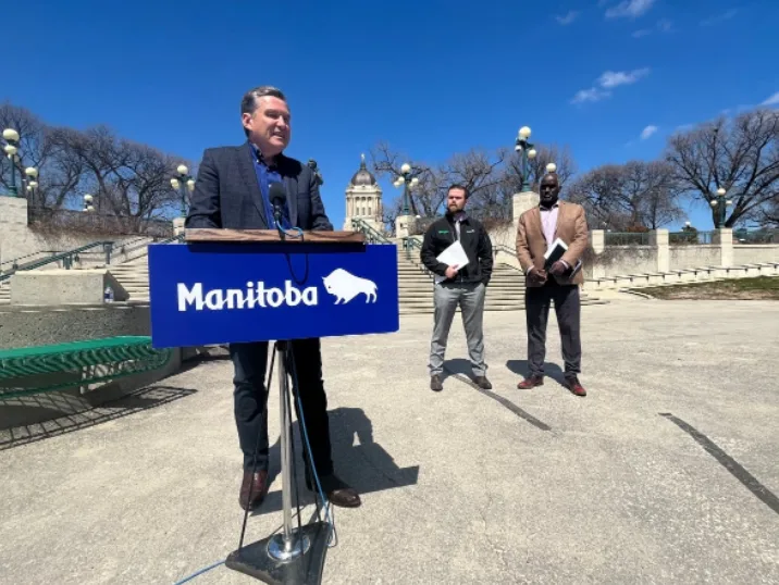
Manitoba Infrastructure Minister Doyle Piwniuk, standing near the Assiniboine River with emergency operations assistant deputy minister Johanu Botha and flood forecaster Fisaha Unduche, said Manitoba is working with Indigenous Services Canada to assist Peguis First Nation. (Bartley Kives/CBC)
High water throughout the Red River Valley and overland flooding across southern and central regions of Manitoba have led 25 municipalities to declare a state of emergency, Manitoba Infrastructure Minister Doyle Piwniuk said. That number does not include First Nations in Manitoba.
There are 10 municipal emergency operations centres open, said Johanu Botha, the assistant deputy minister in charge of emergency operations.
About 200 people have been evacuated from municipal properties, he said. About 1,400 have left First Nations as well.
Piwniuk said the province has assisted flooded-out Peguis First Nation by sending 25 pumps to the community along the Fisher River.
Piwniuk said he toured what he described as the devastation in the community, and said the province works with Indigenous Services Canada to respond to flooding on First Nations.
This story, written by Bartley Kives, was originally published by CBC News on May 5, 2022.