La Niña Pattern in an El Niño World, When will it End?

The current weather pattern across Canada does not look anything like what we typically see with El Niño.
It’s official – El Niño is here! On February 14, 2019, the Climate Prediction Centre in the U.S. issued an advisory announcing that the sea surface temperatures in the equatorial Pacific Ocean had met the criteria for El Niño.
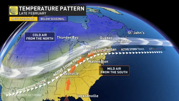
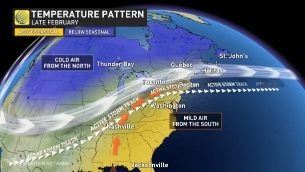
However, the current weather pattern across Canada does not look anything like what we typically see with El Niño. During an El Niño winter, we often see mild Pacific air flood across the country, especially across the West – much like what we saw during December and into January. However, February has featured record cold and abundant snow across much of the West.
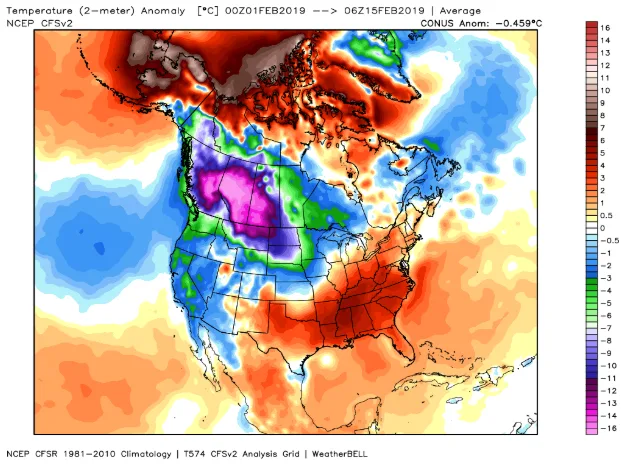
The map below shows temperatures anomalies for the first half of February. The various shades of blue, green and purple highlight the regions that have been colder than normal for February. The brighter shades of violet show that much of B.C., Alberta and Saskatchewan have been 12 to 18 degrees Celsius colder than normal.
This pattern is actually typical of La Niña (the opposite of El Niño). La Niña winters are known for being cold across the west, while the warm weather is typically found across the Southeastern U.S. and at times into adjacent parts of Canada - exactly what we have seen so far in February. We have to go all the way back all the way to the 1950s to find an El Niño year with a pattern that resembles our current pattern.
While this pattern has completely undone our winter forecast across the west, ironically it does fit the headline that we wrote for our winter forecast which proclaimed that “Winter Will Defy Traditional El Niño Pattern Across Parts of Canada”.
We correctly identified the threat for an El Niño defying pattern and we also highlighted the threat for widespread severe cold during late winter, but we thought the severe cold would be focused on the Great Lakes region as it was during the second half of January.
So, where do we go from here? While the severity of the arctic air will relax somewhat at times, the current pattern is expected to persist for roughly ten more days. The image below is a model forecast for February 15 - February 25.
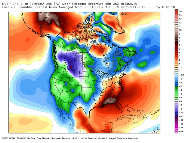
While this doesn’t tell us anything about the details of individual days, it does highlight the continuation of the current pattern with the focus of the arctic air across B.C. and the Prairies. The arctic air will also spread into Atlantic Canada.
Mild air will continue to surge north at times towards the Great Lakes region, which will make Southern Ontario the battle zone between the two air masses and the potential target for more messy systems with mixed precipitation through the end of February.
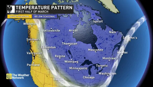
However, as we head towards the beginning of March we do expect some changes in the pattern. As we look at the global pattern, some changes are already in motion on the other side of the world which should shift the focus of the frigid weather somewhat to the east as we head into early March. This should result in milder weather for B.C. and eventually into Alberta, but the central and eastern Prairies will likely remain colder than normal.
Meanwhile, we expect that colder than normal temperatures will become more dominant across Ontario and into Quebec. As a result, early March could end up feeling more like mid-winter across these regions.
How long will this pattern last and when can we expect more widespread spring weather? Please check back on Monday, February 25th when we release our spring forecast with more details on March and a look ahead to April and May. We will even have a sneak peek at our preliminary thought for the summer.


