Major storm threatens 20-40 cm of snow on the Prairies, avoid travel

The potent storm that blasted B.C. with a dose of wet snow, heavy rain and strong winds Monday, resulting in power outages, will continue to push heavy snow across the Prairies Tuesday. The wintry blast will impact travel in Alberta, as snow becomes widespread in Saskatchewan in the morning and reaches Manitoba in the afternoon. This may be the last chance for a white Christmas for the region. A swath of 20-40 cm of snowfall is expected through the southern Prairies, with Calgary in line to get up to 30 cm. Higher elevations of the foothills could even see to 30-50 cm by the time it tapers off. Drivers are being urged to consider postponing non-essential travel until conditions improve. More on the timing and impact, below.
WEATHER HIGHLIGHTS:
Snow continues into Tuesday for Alberta, spreads east into Saskatchewan, Manitoba
20-40 cm possible in western Manitoba, 20-30 cm in Calgary, parts of Saskatchewan
Blowing snow will make travel difficult in all three Prairie provinces
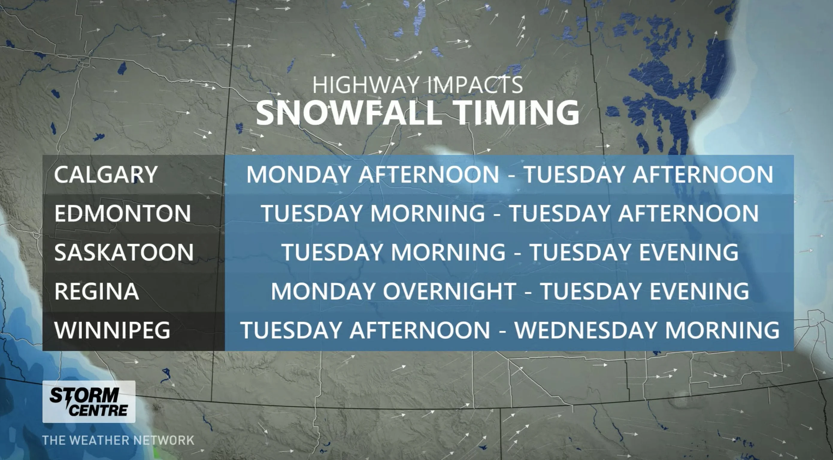
TUESDAY: SNOWFALL SPREADS EAST, TRAVEL TO BE IMPACTED
As the heavy snow hangs on in southern Alberta and Saskatchewan Tuesday morning, areas in the northern sections of the former, along with central sections of the latter, will see the snow begin to fall then. The system will then edge into southern Manitoba in the afternoon, with snowfall starting for Winnipeg at that time.
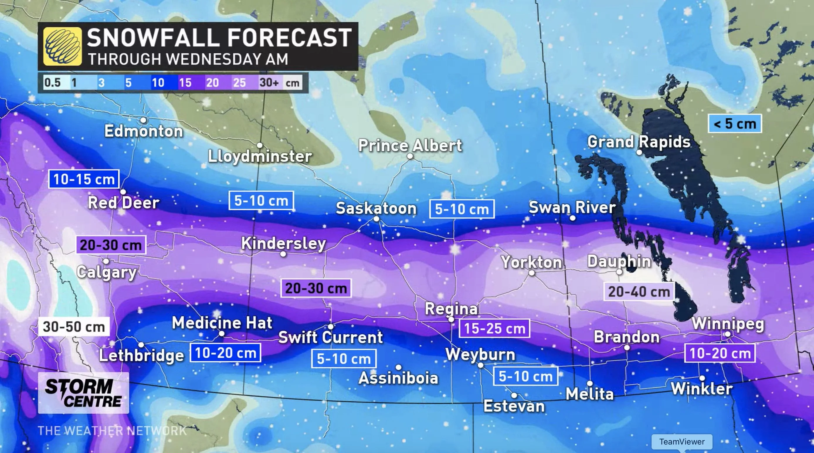
Through Wednesday morning, snowfall totals will vary across the Prairies, with the heaviest amounts expected in southern Alberta and Manitoba.
Calgary may between 20-30 cm of snow when all is said and done, though areas within the city may see a wide range of accumulations. Even greater amounts are expected along the higher terrain of the foothills, with some upsloping enhancement expected due to easterly winds, which could bump snowfall amounts to 30-50 cm.
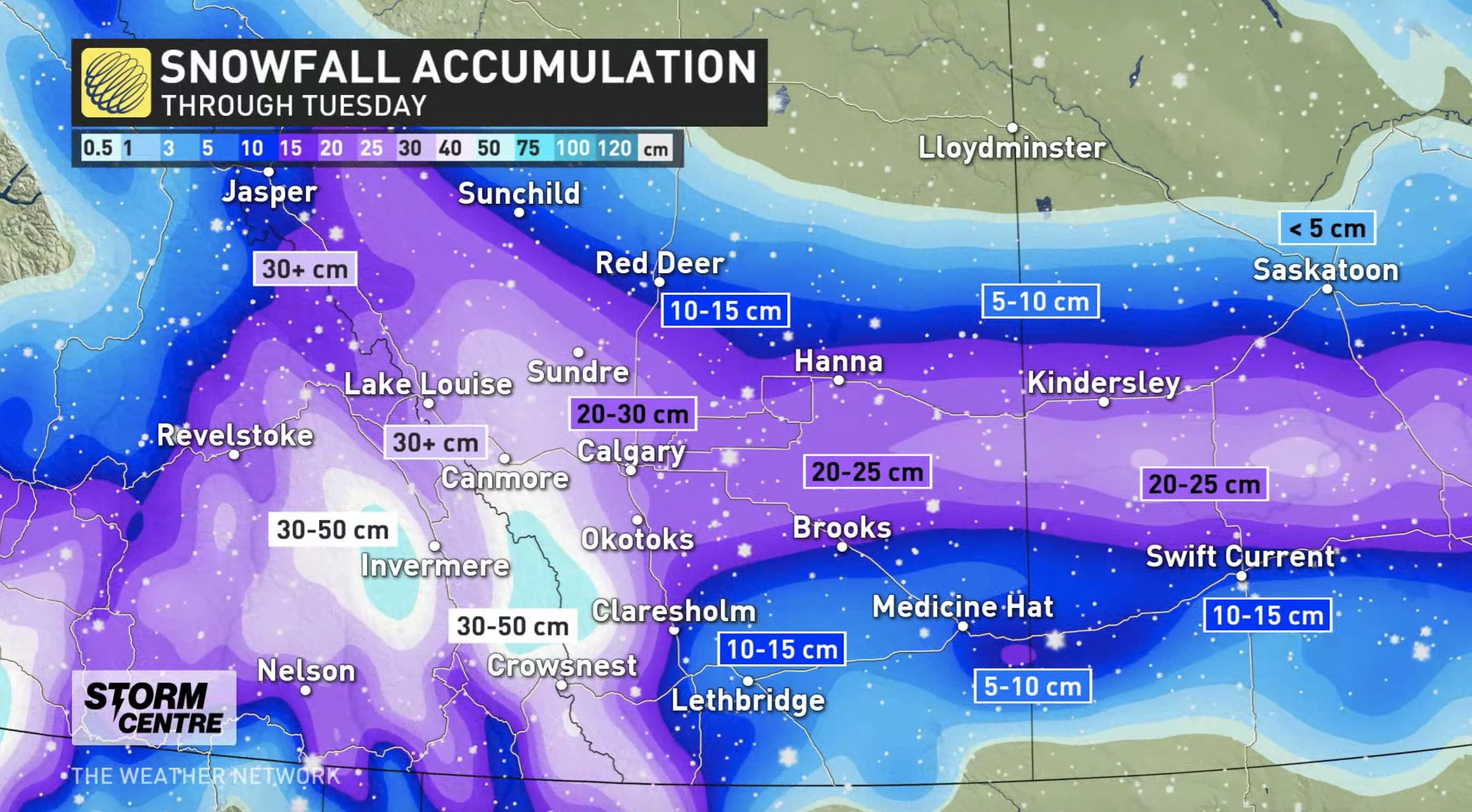
As much as 20-40 cm of snow could fall in parts of western Manitoba, 20-30 cm in central and eastern Saskatchewan. Regina may see 15-25 cm, while 10-20 cm is forecast for Winnipeg. Parts of extreme southern and eastern Saskatchewan are expected to see a general 5-15 cm.
Winter storm and snowfall warnings cover much of southern Alberta, Saskatchewan and Manitoba for the snow impacts that will linger into Wednesday for the latter.
DANGEROUS DRIVING ON MOUNTAIN PASSES, SLICK ROADS WITH POOR VISIBILITY ALONG COAST
As well, strong northerly winds will develop on Tuesday morning in southern Alberta and western Saskatchewan. Gusts to 80 km/h are expected to produce blowing snow until the late afternoon and ealry evening hours.
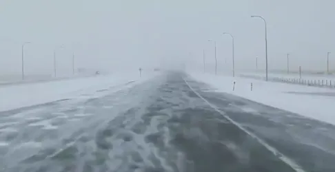
The snow is likely to impact travel along the major roadways of the southern Prairies and motorists are urged to cancel any non-essential travel. There may be a significant impact on rush hour traffic in urban areas on both Monday night and Tuesday morning as the snowfall rates pick up across the region.
"There's moderate confidence for this system to affect travel along major routes through one of the busiest travel times of the year, despite COVID-19 restrictions," says Weather Network meteorologist Nadine Hinds-Powell, adding that the probability for a white Christmas is now "high" for many of these impacted areas.
Snowfall will taper off in Alberta by Tuesday evening, in Saskatchewan Tuesday overnight and by Wednesday afternoon in Manitoba.
Thumbnail courtesy of Kyle Brittain.
Be sure to check back as we continue to monitor the weather in your area.


