Messy Atlantic Canada storm raises flood concerns from rain, wind threats

Atlantic Canada is bracing for a potent winter storm, set to bring heavy snow, ice pellets, rain and blustery winds Tuesday.
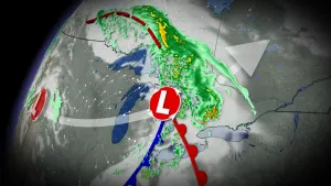
Canada's East Coast will be on the receiving end of a substantial winter storm Tuesday that is also battering the northeastern U.S. with heavy snow. Atlantic Canada can expect to see quite the mess with the storm's setup -- hefty snow, rain, ice and howling winds. Parts of the region are looking at considerable amounts of snowfall -- with 20-40 cm forecast for parts of extreme northern New Brunswick and Cape Breton Island, and 10-20 cm in the southern Maritimes. Rainfall will also be quite substantial, as high as 50-75 mm along southern coast of Nova Scotia, elevating the risk of localized flooding. There is also the threat of ice pellets during the transition from snow to rain. The other issue will be the winds, which are expected to be powerful, particularly in the Les Suêtes region. Widespread warnings and special weather statements are in effect. More details on the timing and impact, below.
WEATHER HIGHLIGHTS:
Winter storm batters Atlantic Canada with snow, rain, ice pellets, intense winds Tuesday
20-40 cm for parts of northern New Brunswick and eastern Nova Scotia, 10-20+ cm for southern Maritimes
Threat for localized flooding with heavy rain expected along the Atlantic coast of Nova Scotia
TUESDAY-WEDNESDAY: SIGNIFICANT IMPACTS FROM WINTER STORM, WARNINGS EXPAND
A strong East Coast storm will be in full swing in the Maritimes by Tuesday morning, with some messy precipitation spreading through the day. The system is also bringing widespread, significant impacts to the northeastern U.S.
Winter storm, snowfall, rainfall, wind and warnings, as well as special weather statements are in place across the region.

Tuesday morning will see snow switch to rain, at times heavy, in southwestern Nova Scotia and by the afternoon in the northern sections of Cape Breton. The rain will taper to showers Wednesday morning.
In New Brunswick, snow will begin early Tuesday morning in the southwestern sections, then reaching northeastern regions by the afternoon period. In the southern half of the province, snow will change through ice pellets and freezing rain to rain.
MUST SEE: Winter will attempt to make up for lost time during February across Canada

Because Quebec and northern New Brunswick will be on the cold side of the system, which could result in 10 cm as far west as Montreal, and possibly 20-40 cm for parts of far northern New Brunswick with snowfall occurring for more than 12 hours. Cape Breton Island may also see 20-40 cm of snow.
Drivers are being urged to plan ahead, and to adjust to the changing road conditions with the accumulating snow, which will make travel very difficult.

Although the bulk of the Maritimes will see 10-20+ cm for areas further inland, it will be followed by significant rain for the southern sections, which will quickly wash away the accumulated snowpack.
Any changes in the timing of the changeover to rain could impact accumulations in these regions.
50-75 mm of rain is expected for coastal Nova Scotia, 20-50 mm further inland, and 10-20 mm for southern New Brunswick. Temperatures stretch to nearly 10°C for the southern shores of Nova Scotia by the pre-dawn hours Wednesday morning.
"Heavy downpours can cause flash floods and water pooling on roads," says Environment Canada in a rainfall warning issued for the Halifax area Monday morning. "Localized flooding in low-lying areas is possible."

NEXT STORM ON THE WAY FOR ATLANTIC CANADA
On top of the significant rain and snow, along with ice pellets, intense easterly winds will develop with this system, with 80-100 km/h gusts expected for coastal areas on Tuesday afternoon.
Snow will begin in southwestern Newfoundland first, arriving Tuesday evening, then changing over to ice pellets before transitioning to rain Wednesday morning.
Snowfall amounts for Newfoundland will vary, with 20-30 cm for the northern coast, 15-25 cm for southwestern coast and 10-20 cm for central inland regions. Less than 5 cm is anticipated for the Avalon.

Rainfall totals will be heaviest along the southern coastal areas of the island, with 20-40 mm expected. Amounts decrease as you head further inland.
Winds will also be intense for Newfoundland, ramping up through the overnight hours on Tuesday and continuing into Wednesday morning, especially in areas prone to enhanced easterly winds. Southeasterly gusts of 80-100 km/h will develop. Gusts may even hit 110 km/h along the western coast. Winds will diminish Wednesday evening.
Les Suêtes winds are expected to peak to 140 km/h Tuesday afternoon, increasing to 170 km/h in the overnight hours.
Beyond the storm, temperatures will turn briefly colder but still seasonal, before they become much milder ahead of the next system that will push through for the weekend.
NEWFOUNDLAND, YOUR STORM BREAKDOWN THROUGH WEDNESDAY
Be sure to check back as we continue to monitor the track of this strong winter storm for Atlantic Canada.