Central Canada may be in for a wild Tuesday: Storm, flood and waterspout risk

With cooler temperatures in place across Central Canada, the risk of waterspouts and thunderstorms lingers across parts of the region Tuesday, with potentially flooding rainfall for portions of eastern Ontario and Quebec
With fall around the corner, southern Ontario and Quebec are getting a taste of what's to come this week. Temperatures have dropped quite a bit and a disturbance in the upper atmosphere could bring heavy rain, localized flooding, thunderstorms and waterspouts on Tuesday. Parts of eastern Ontario and Quebec may see 50-75 mm of rain, even more than 100 mm locally, raising the risk of flooding. More on the timing, and storm and waterspout risk Tuesday, plus the impressive temperature record reached, below.
Tuesday: Risk for rain, thunderstorms, localized flooding and waterspouts
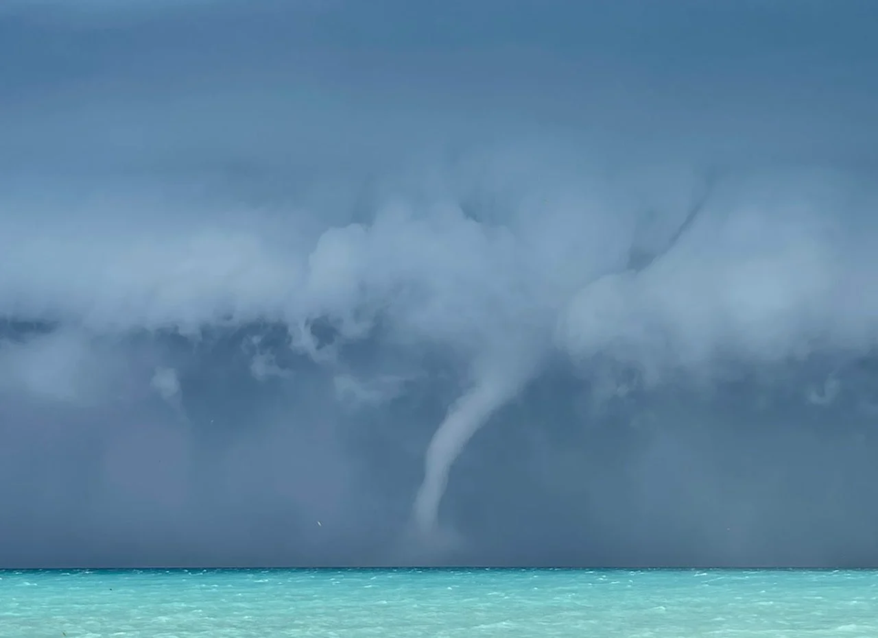
The temperature difference between the Great Lakes and ambient air can be quite significant during this time of the year, which adds to the risk of waterspouts on Tuesday. While every lake faces the threat, Lake Erie has the greatest chance of seeing them. As of Sept. 12, the water temperature in Lake Erie remains over 23°C, providing ample instability with the cooler air stacked aloft.

Waterspouts are common across the Great Lakes during the late summer and early fall months. A waterspout is typically harmless if you maintain a safe distance.
Embedded thunderstorms will also be in the forecast again Tuesday for southern Ontario and much of Quebec, though remaining non-severe in nature. Periods of heavy rain will be the main threat with the storms that do develop.
In eastern Ontario and Quebec, where there is more moisture available in the atmosphere, stronger storms are possible. As a result, heavier rain is expected, prompting Environment and Climate Change Canada (ECCC) to issue rainfall warnings.

Some areas in the warned regions could see 50-75 mm of rain, potentially exceeding 100 mm locally with embedded thunderstorms. As a result, localized flooding is possible.
Showers will end through the afternoon, then clouds will give way to some sunshine from southwest to northeast, but remaining mostly cloudy for areas north and northeast of the Greater Toronto Area (GTA).
Daytime high temperatures will fall into the lower 20s with comfortable levels of humidity.
Temperatures haven't dropped below 20°C in 80+ days
After a cold front passes on Wednesday, temperatures will peak in the high teens on Thursday, which will be the first day that the GTA has seen a temperature below 20°C since June 18.
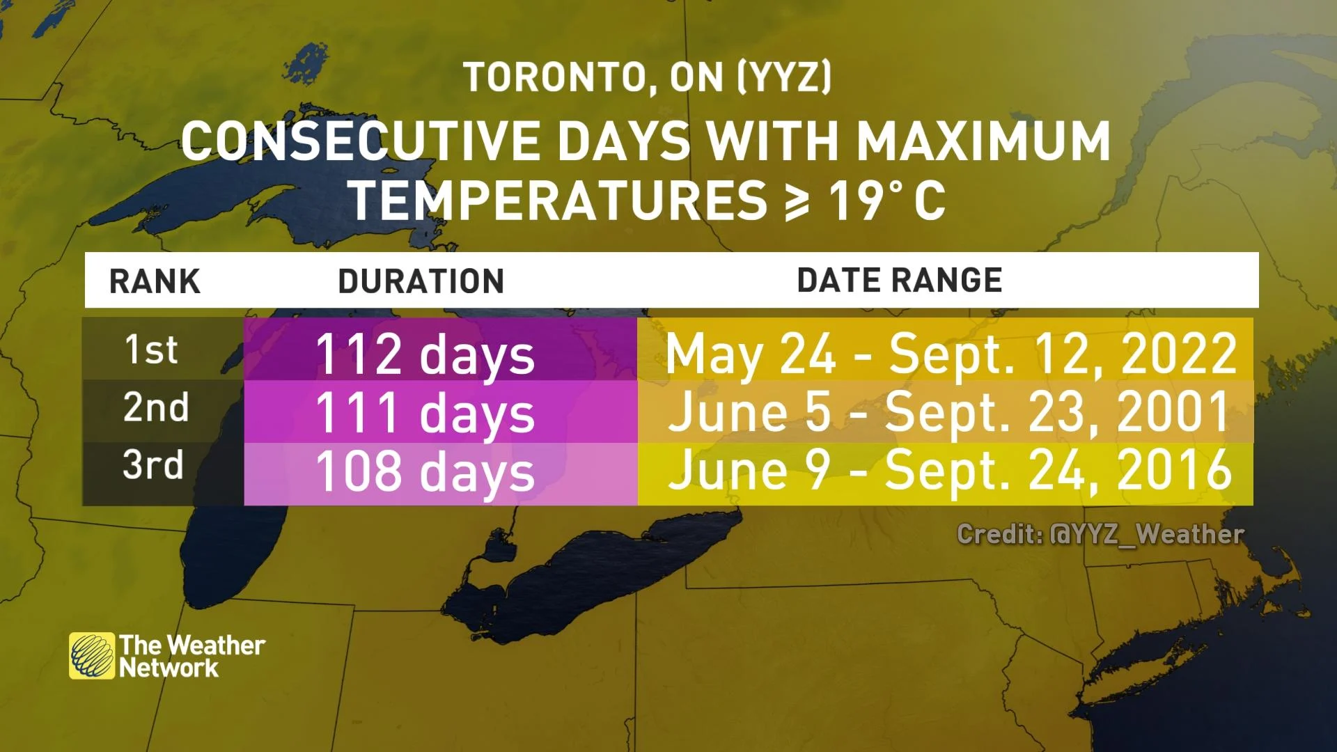
In fact, Monday marks the 112th consecutive day with temperatures greater than 19°C, a streak dating back to the end of May.
Temperatures will bounce back to summertime levels by the weekend as a trough moves off to the east. The humidity looks to return to the province by the weekend, as well.

Thumbnail courtesy of MaryAnn Williams, taken in Port Albert, Ont.
Check back for the latest conditions across Ontario.