PHOTOS: Hundreds rescued amid Hurricane Sally's heavy rain, flooding

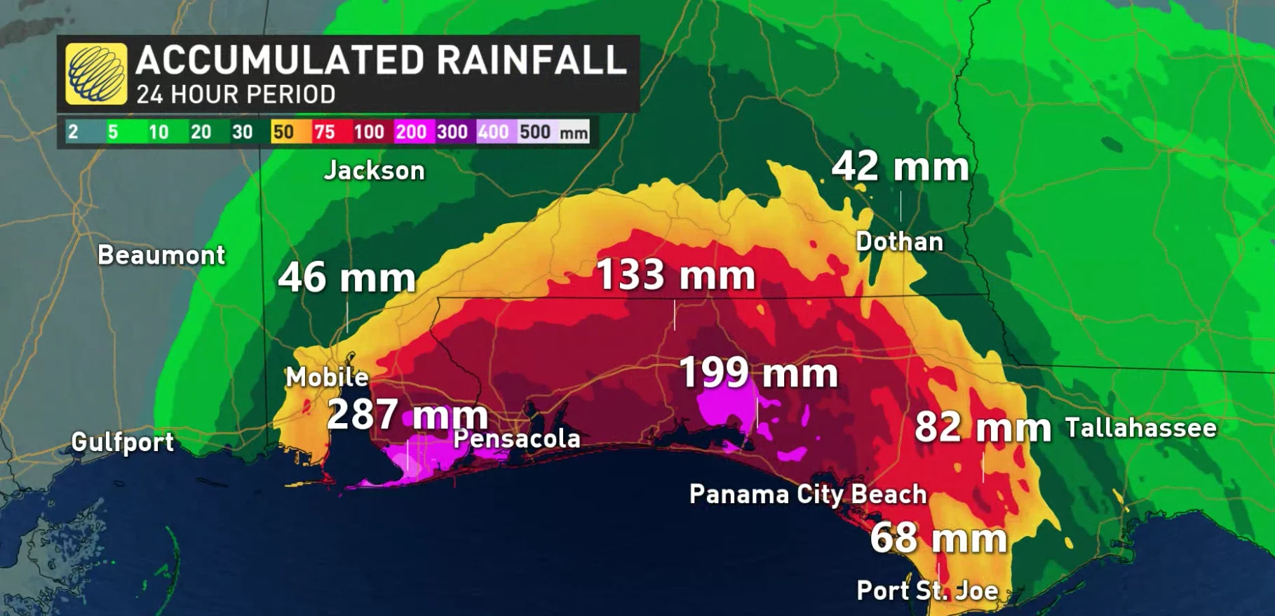
Hurricane Sally made landfall overnight Wednesday. Life-threatening winds and flooding hit areas of Alabama and Florida. The system tracked northeast on Thursday, where it is expected to bring more than a foot of rain to some areas. Latest, here.
Hurricane Sally intensified before it made landfall as a Category 2 with 165 km/h winds and heavy rain on Wednesday.
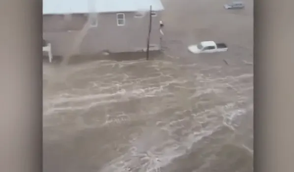
Authorities in Escambia County, Florida, say at least 377 people have been rescued from flooded areas, as reported by CBC. The rescues include at least 40 people that were trapped by high water, including a family of four found in a tree, according to Sheriff David Morgan.
Officials across the South had called on residents of low-lying areas to shelter away from rain and winds. On Wednesday morning, a sustained wind of 130 km/h and a gust of 159 km/h was reported at Dauphin Island, Alabama. A sustained wind of 98 km/h and a gust of 139 km/h was observed at the Pensacola Naval Air Station, in Pensacola, Florida.
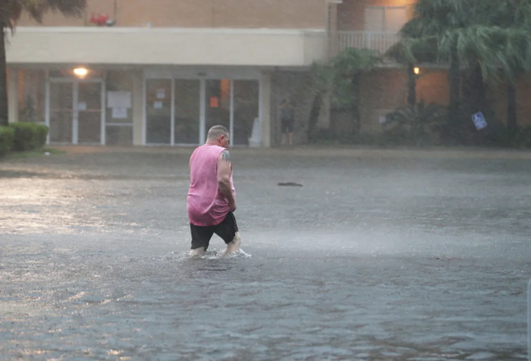
GULF SHORES, ALABAMA - SEPTEMBER 15: A man walks though a flooded parking lot as the outer bands of Hurricane Sally come ashore on September 15, 2020 in Gulf Shores, Alabama. The storm is bringing heavy rain, high winds and a dangerous storm surge from Louisiana to Florida. (Photo by Joe Raedle/Getty Images)
CURRENT STATE OF SALLY
As of Thursday morning, Sally "is moving toward the northeast near 12 mph (19 km/h), and a northeastward to east-northeastward motion is expected into Friday. On the forecast track, the center of Sally will move across southeastern Alabama this morning, over central Georgia this afternoon and evening, and move over South Carolina late tonight into Friday," says the National Hurricane Center (NHC).
Sally's maximum sustained winds have significntly decreased to 45 km/h. Over the next few days additional weakening is projected, and the system should become a remnant low by tonight or Friday morning.
IMPACT OF SALLY
More than 430,000 homes and businesses were without power in Alabama and Florida early Wednesday, according to local utilities, with more outages expected.
In downtown Mobile, strong winds shook windows, while trees and power lines swayed. Dexter Hart, who lives near the city, relocated to a hotel in the area because his house is surrounded by trees.
Damage from Sally is expected to reach $2 billion to $3 billion, said Chuck Watson of Enki Research via Reuters. Enki Research tracks tropical storms and models the cost of their damage. That estimate could rise if the heaviest rainfall happens over land, Watson told the news agency.
Ports, schools and businesses were closed along the coast as Sally churned. As the storm track shifted east, ports along the Mississippi River were reopened to travel on Wednesday, but they were closed to vessel traffic from Biloxi, Mississippi, to Pascagoula, Florida.
Energy companies also shut more than a quarter of U.S. Gulf of Mexico offshore oil and gas production, and some refiners halted or slowed operations.
As far as what's happening at ground-level, here's the latest in photos and videos:
And this is what the National Oceanic and Atmospheric Administration satellites captured:
Contains files from Reuters


