
Hurricane Larry will set its sights on Newfoundland Friday night

Forecasters are tracking Hurricane Larry as the storm churns over the western Atlantic Ocean. The system will likely bring hazardous conditions to Newfoundland’s Avalon Peninsula beginning late Friday and ending early Saturday. Potential impacts include strong winds, heavy rain, rough surf, and rip currents.
LARRY WILL BRUSH BERMUDA ON THURSDAY
Hurricane Larry weakened a bit late Wednesday. The U.S. National Hurricane Center (NHC) found that Larry’s maximum sustained winds had dropped to 170 km/h on Wednesday evening, which makes the storm a strong Category 2 on the Saffir-Simpson Scale.
The NHC expects Larry to maintain hurricane intensity over the next couple of days.
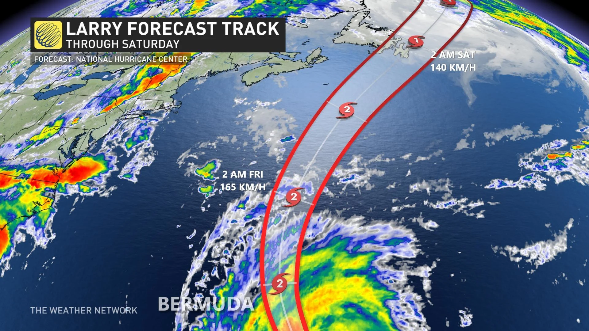
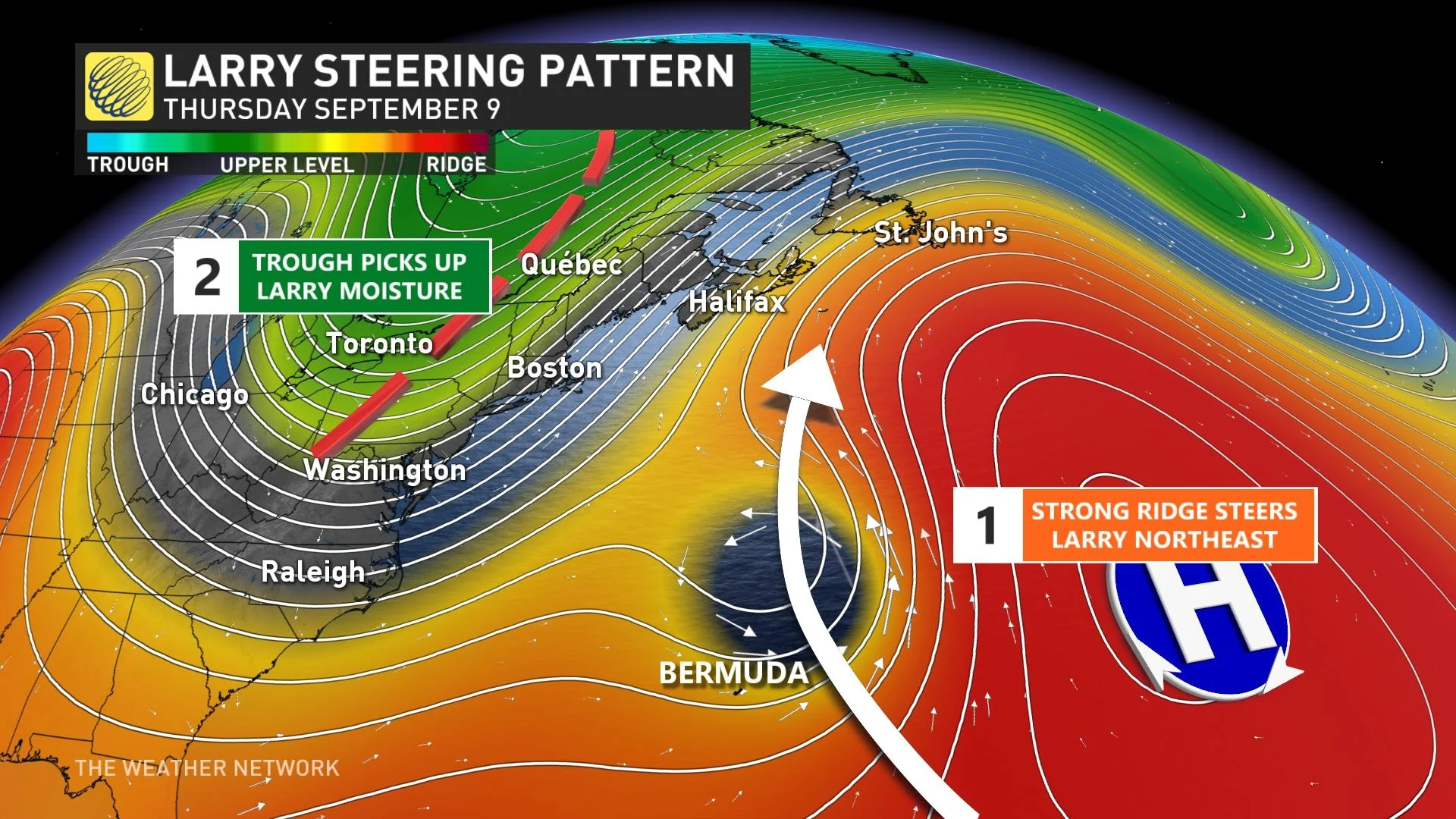
A ridge of high pressure over the western Atlantic Ocean will steer Larry east of Bermuda on Thursday. A tropical storm warning is in effect for the island in anticipation of squally weather there.
After passing Bermuda, Larry will round the edge of the ridge and set its sights on eastern Newfoundland.
LARRY’S STRUCTURE BEGINS TO CHANGE FRIDAY
Hurricane Larry’s internal structure will begin to change as it picks up speed and heads toward Newfoundland on Friday.
Environment and Climate Change Canada (ECCC) issued a tropical cyclone statement on Wednesday ahead of the storm’s final approach.
"Larry will be undergoing transition to a post-tropical storm while traveling very quickly through the region as a trough of low pressure approaches from the west. At this time we anticipate a period of heavy rainfall lasting a few hours as the storm tracks through, even if the centre passes offshore to the east of the Avalon," warns ECCC.
A post-tropical storm means that the storm will lose its tropical characteristics. When a hurricane undergoes this transformation, the system’s energy spreads out and away from the centre of the storm. After this transition, Larry’s strongest winds will be on the eastern side of the storm.
STRONG WINDS AND HEAVY RAIN REACH NEWFOUNDLAND FRIDAY NIGHT
Based on the NHC’s projected path, the centre of Larry will pass over or very close to the Avalon Peninsula on Friday night.
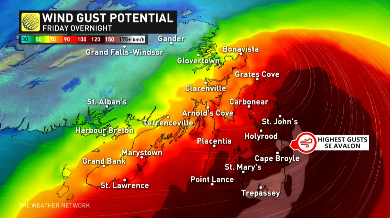
The storm’s precise track is important as it will determine the path of the strongest winds.
A track over the Avalon would bring strong winds to the eastern Avalon, while a track offshore would keep the strongest winds offshore as well.
If the centre of the system tracks directly over the Avalon, wind gusts of 100-120+ km/h are possible there during the height of the storm.
Rainfall totals of 20-50 mm are possible by the end of the storm.
The fast-moving system should clear away from Newfoundland on Saturday morning.
DANGEROUS SURF AND RIP CURRENTS ARE LIKELY
Even though Larry’s direct impacts will be limited to southeastern Newfoundland, we could feel the effects of the storm across the Maritimes through this weekend.
Larry is a large and powerful hurricane. The storm’s winds generated significant swells that will buffet the coast over the next few days. Coastal areas in Nova Scotia and Newfoundland may witness dangerous surf and rip currents as the storm passes the region to the east.
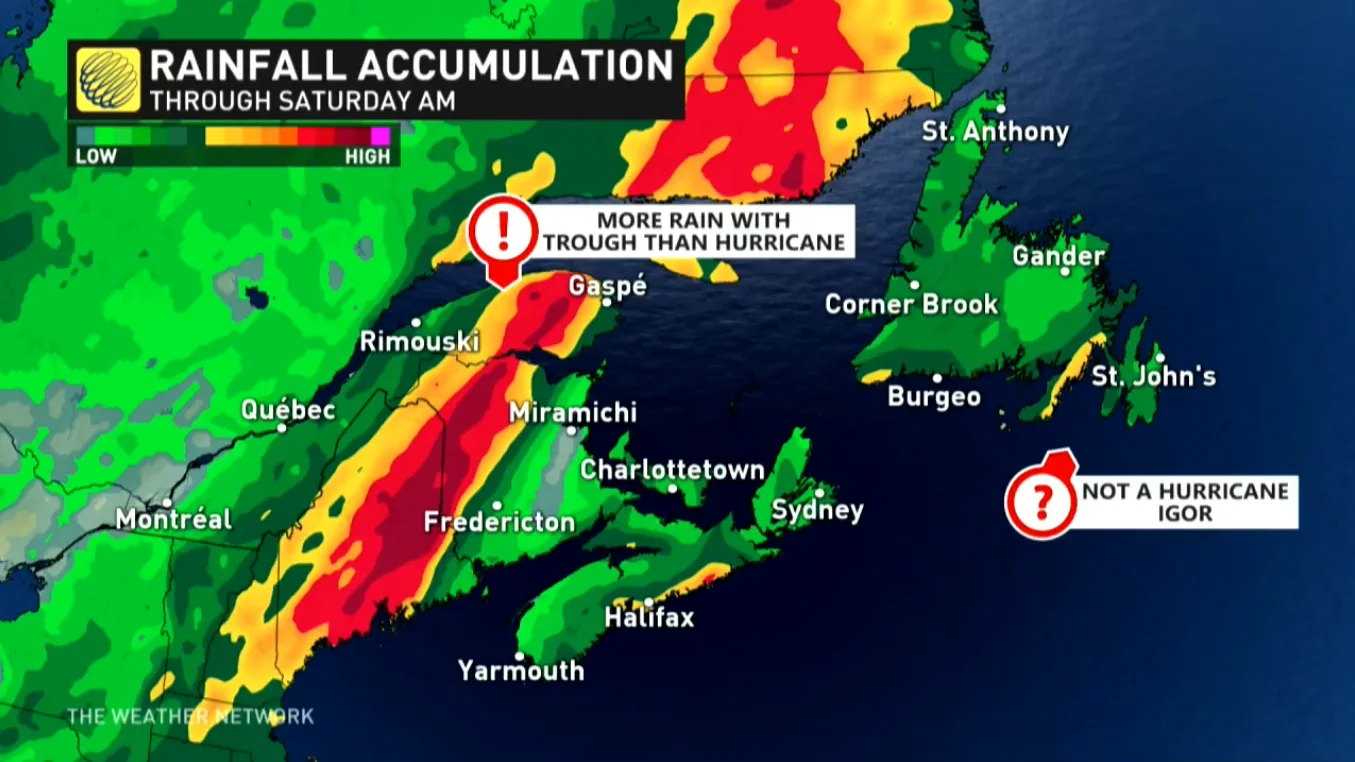
The system could also influence heavy rain over parts of the Maritimes.
"While Hurricane Larry will not have a direct impact on the Maritimes, it will be a key factor for causing the front to slow as it tracks into the region, bringing widespread rain and thunderstorms to the region," says Dr. Doug Gillham, a meteorologist at The Weather Network.
Rainfall totals of 40-80 mm are expected for parts of the Maritimes, eastern Quebec, and southeastern Labrador.
Thumbnail of Hurricane Larry courtesy of NOAA.
Stay tuned to The Weather Network for the latest updates on Hurricane Larry.


