Hurricane Fiona threatens severe impacts across Atlantic Canada

Be prepared: Hurricane Fiona expected to impact Atlantic Canada starting Friday, and continuing into the weekend.
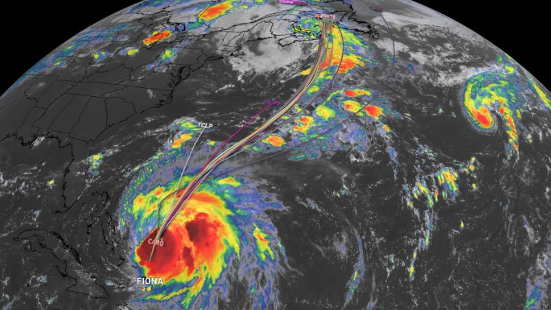
Hurricane Fiona is roaring through the western Atlantic Ocean as a powerful Category 4 storm. The hurricane will brush Bermuda overnight Thursday before threatening major impacts across a large portion of Atlantic Canada.
This is already a deadly hurricane. Five people died after Fiona produced devastating flooding across Puerto Rico as the storm traversed the Caribbean island. The storm went on to batter the Dominican Republic and the Turks and Caicos Islands, the latter of which experienced the storm as it strengthened into a major hurricane.
Summer’s final sunset saw a powerhouse of a storm in Hurricane Fiona. The U.S. National Hurricane Center (NHC) found the storm had maximum sustained winds of 215 km/h on Wednesday evening. Some additional strengthening is forecast through Wednesday night, with some fluctuations in intensity possible on Thursday.
Forecasters are keeping a close eye on potential impacts across Atlantic Canada for this weekend.
RELATED: Hurricane Fiona strengthens to Category 4 storm as it heads toward Bermuda
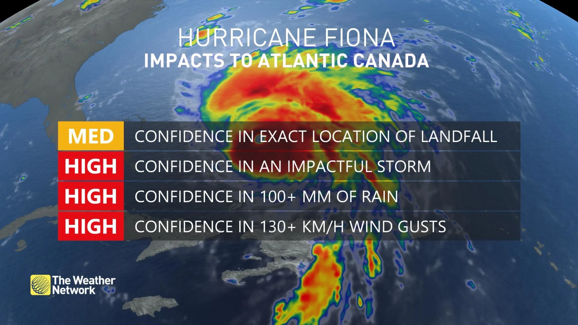
While the exact track is still uncertain, there is little doubt that Fiona will have a major impact on the region. Residents should plan and prepare for the storm and its significant impacts now, before conditions start going downhill on Friday and Saturday.
Environment and Climate Change Canada (ECCC) issued a tropical cyclone information statement from the Canadian Hurricane Centre (CHC) and it covers the entire region.
"This storm is shaping up to be a potentially severe event for Atlantic Canada. Numerous weather models are quite consistent in their prediction of what we call a deep hybrid low pressure system, possessing both tropical and intense winter storm-type properties (but with very heavy rainfall and severe winds)," the CHC said in the updated statement Wednesday morning.
Hurricane Fiona will continue on a northeasterly track that takes it close to Bermuda overnight Thursday into Friday morning. From there, an upper-level trough will grab the storm and pull it northwest toward Atlantic Canada.
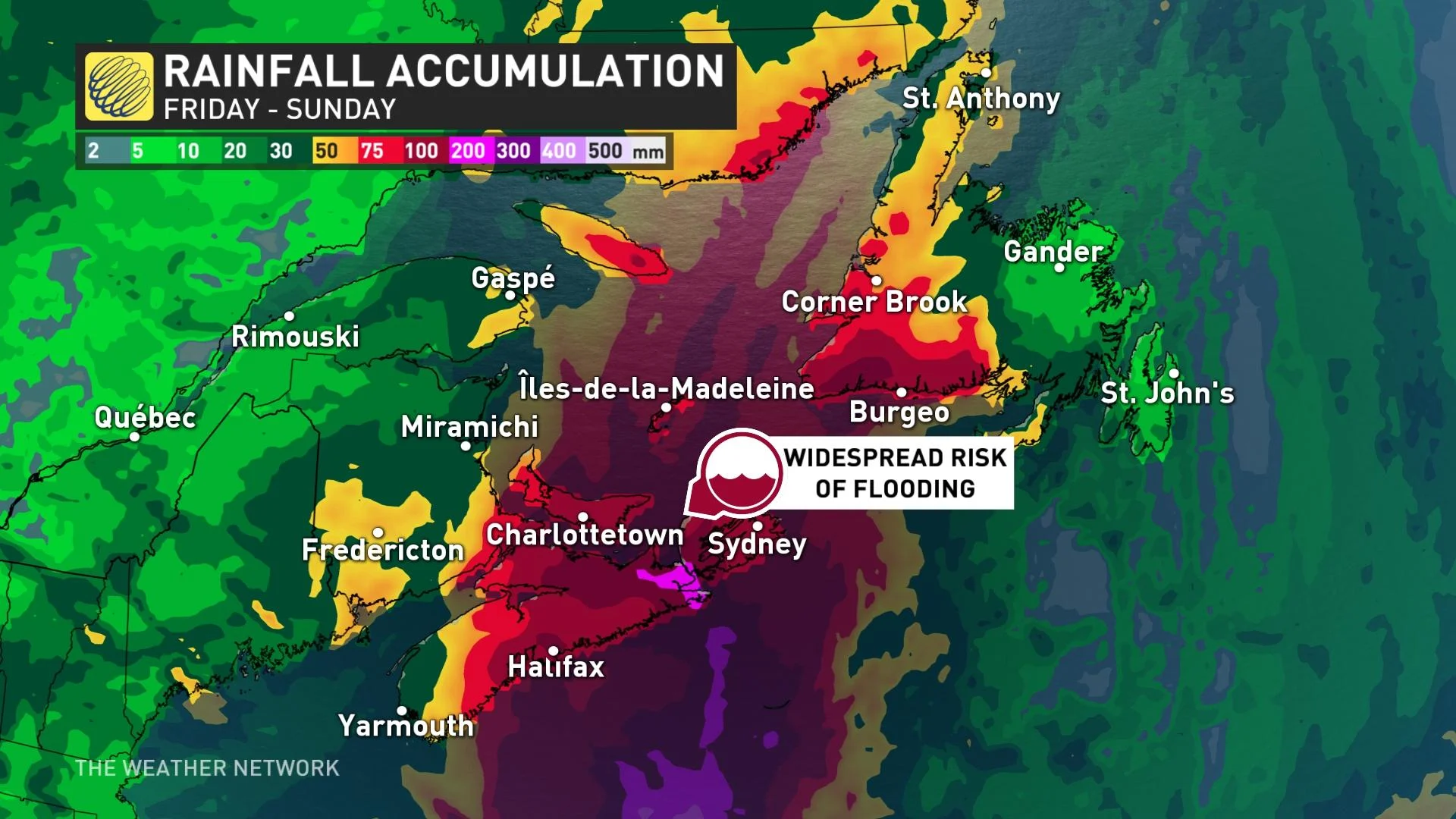
This trough will help the storm transform into a large and potent post-tropical cyclone by late Saturday. Landfall is expected across eastern Nova Scotia by Saturday morning.
"Since we expect the storm to become very large, the impacts will be multi-provincial," the CHC adds.
Warm water temperatures in the western Atlantic are contributing to the storm’s strength. These waters are much warmer than normal, allowing the storm to maintain tropical characteristics and delaying its transition to extratropical cyclone status.
DON'T MISS: Essential items for your emergency "grab-and-go" kit
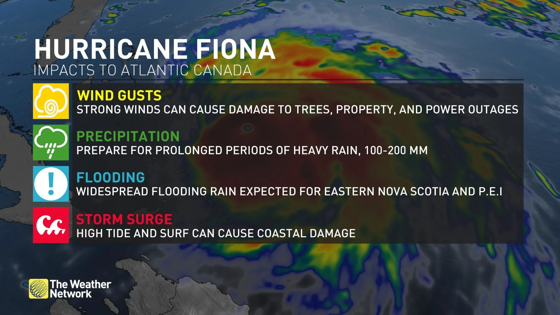
Possible impacts include:
Large waves
Swells
Storm surge
Damaging winds
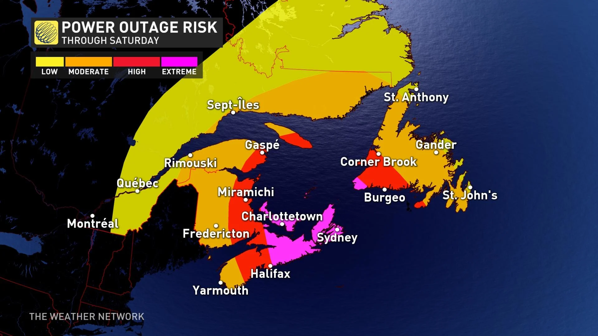
Widespread power outages
Heavy rain
Flooding
A widespread swath of 100+ mm of rain is likely across parts of Atlantic Canada with Fiona. The exact location of the heaviest rain is still to be determined, but some computer models are suggesting as much as 200 mm for the hardest-hit areas. There's a chance of flooding from central Nova Scotia eastwards, and into southwestern Newfoundland as well.
DON'T MISS: What to do before, during, and after a hurricane landfall
High winds will cause major issues across the region. Gusts of 100+ km/h as Fiona slams into the the Atlantic provinces. The system’s transition from a tropical cyclone to a post-tropical cyclone will expand its wind field, exposing a much larger area to strong winds.
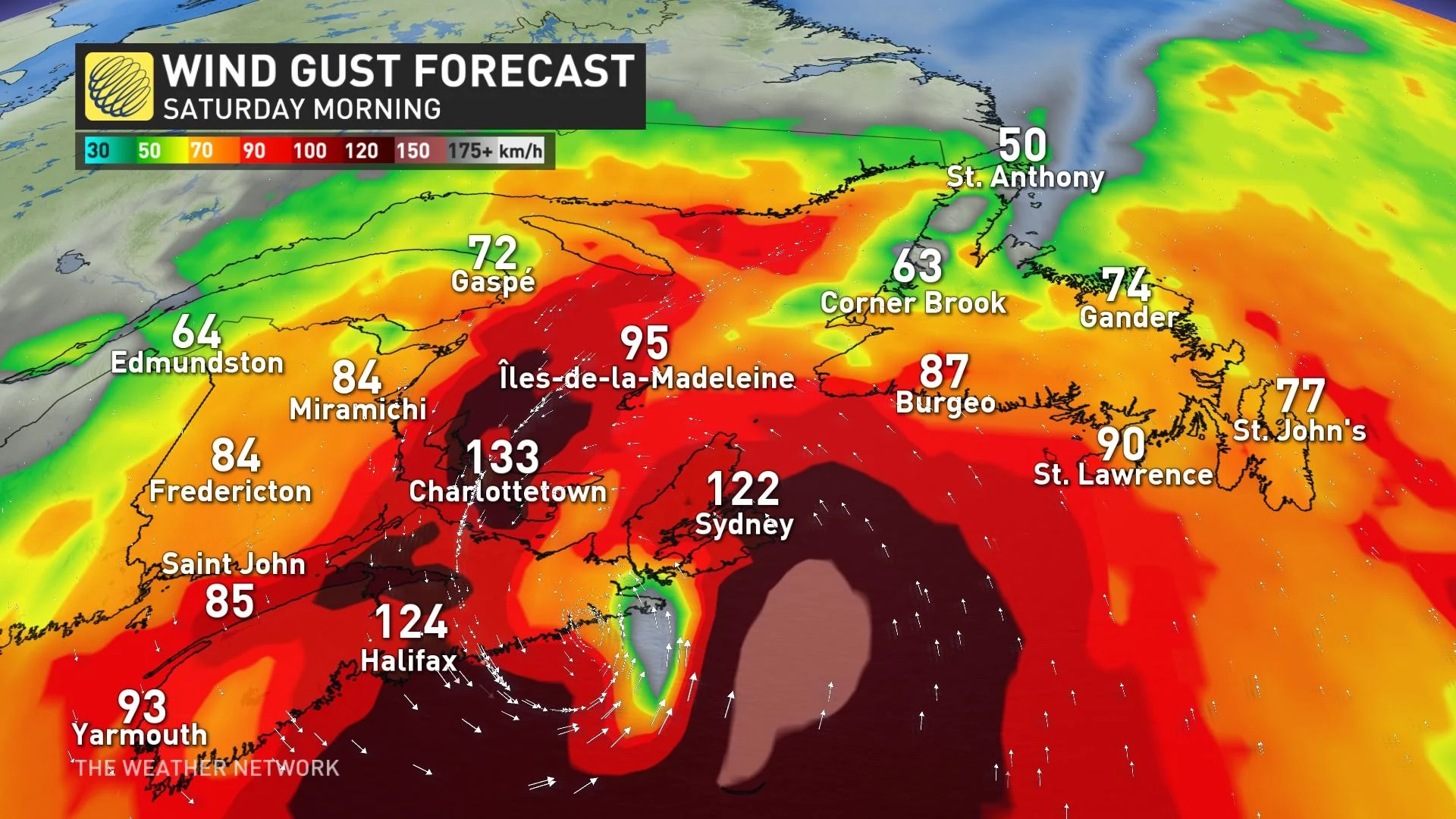
"Winds are strongest in the eye of the storm when it is a tropical system," says Matt Grinter, a meteorologist at The Weather Network. "As it starts to transition into a post-tropical storm, those strong winds start to expand throughout most of the system."
Even stronger gusts upwards of 150 km/h are possible for eastern Nova Scotia and PEI. With trees still in full leaf, there will also be a widespread risk of power outages across the region.
WATCH: Canadians rush for supplies as Hurricane Fiona takes aim
Residents across the region are being urged to start with preparations now. Making sure an emergency kit is ready, clearing downspouts and storm drains and having generators in working order, are all important factors to take into account.
Nova Scotia Power announced on Wednesday that the company will activate its Emergency Operations Centre at 8:00 a.m. on Friday.
“Based on the recent weather forecasts, we are opening our Emergency Operations Centre Friday at 8am to ensure proper plans and crews are in place to manage our storm response,” the company said in its press release.
P.E.I.'s Emergency Measures Organization (EMO) is activating to Level 1 enhanced monitoring and is encouraging Islanders to replenish supplies for up to five days, including food, water, heat and fuel supplies.
In Newfoundland's west coast city of Corner Brook, Mayor Jim Parsons said sandbags are already being filled, catch basins are being cleared and trees are being trimmed in anticipation of the hurricane-force winds.
Stay tuned to The Weather Network for the latest forecast details on Fiona's track and possible impacts on Atlantic Canada.
With files from CBC.