Hurricane Fiona rapidly nearing historic Atlantic Canada landfall

Residents of Atlantic Canada should brace for rapidly deteriorating conditions as powerful Hurricane Fiona marches toward an overnight landfall.
Folks across Atlantic Canada should prepare to hunker down for the duration of Fiona as the powerful storm begins to push into the region. Conditions will quickly deteriorate through overnight hours on Friday as the hurricane grows and nears landfall.
DAMAGE: Hundreds of thousands without power as Fiona bears down on the Maritimes
Autumn’s first sunset fell across Hurricane Fiona as the storm maintained major hurricane strength. The storm entered Friday evening with maximum sustained winds of 205 km/h, making it a powerful Category 3 as it neared the next stage of its eventful life.
An upper-level trough swinging over Eastern Canada forced the storm to transition into a powerful post-tropical cyclone late Friday night, allowing the storm’s wind field to grow in size as it smashes into the Atlantic provinces through Saturday.
Even though the U.S. National Hurricane Center (NHC) has declared the system “Post-Tropical Cyclone Fiona,” that’s mostly a technicality in terms of impacts. Fiona remains a large and powerful storm with the intense winds equivalent to those of a Category 2 hurricane.
Fiona will hit Nova Scotia and P.E.I. with all its might Friday night and into Saturday morning, eventually reaching the Quebec lower North Shore and southeastern Labrador early Sunday.
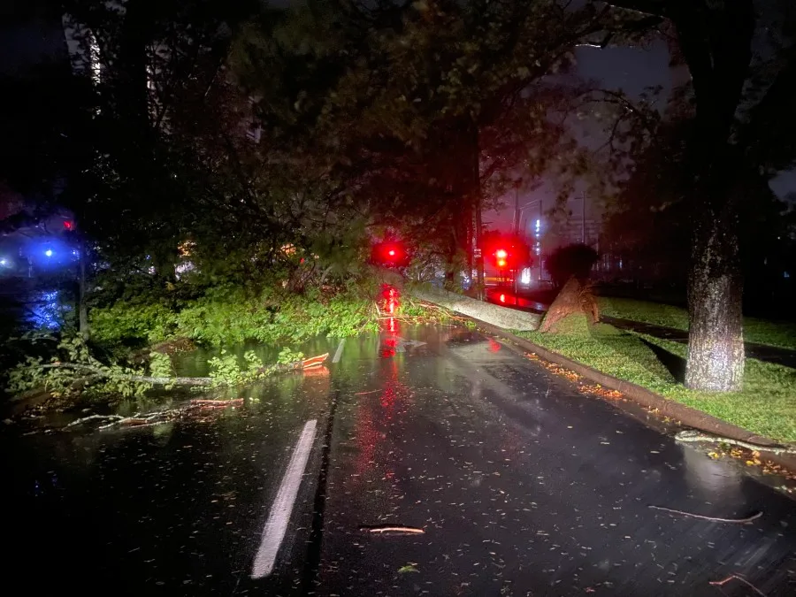
The rain and wind in the storm’s outer bands were already causing significant issues across Nova Scotia late Friday night.
Hurricane safety: What to do before, during, and after landfall
MétéoMédia’s André Monette reported late Friday night that winds gusted to 142 km/h on Beaver Island and 133 km/h on Sable Island. Gusts crept into the 90 km/h range around Halifax as the centre of the storm approached the province.
Nova Scotia Power reported on its website that more than 360,000 customers were already without power by 2:00 a.m. ADT on Saturday. Maritime Electric reported more than 77,000 outages in P.E.I. around the same time, with the outages mostly on the eastern side of the island. In New Brunswick, close to 18,000 were without power as of 3:25 a.m. ADT, according to NB Power.
Expect these numbers to dramatically increase in the coming hours as the heart of the storm draws closer to land.
Fiona could be a legendary storm for Atlantic Canada
"When looking at Fiona, you kind of get that sinking feeling in the pit of your stomach, and it's something as a meteorologist you don't get all too often," says Tyler Hamilton, a meteorologist at The Weather Network.
DON'T MISS: Essential items for your emergency "grab-and-go" kit
WATCH: Why Hurricane Fiona's 'left hook' will pack a serious punch
This is not just a hurricane either, it's more like a hurricane and a nor'easter combined. It's like comparing the intensity of Hurricane Juan, which was the most devastating storm to hit the Maritime provinces, combined with the size of Hurricane Dorian, a massive storm that set a record for the most people without power at one time.
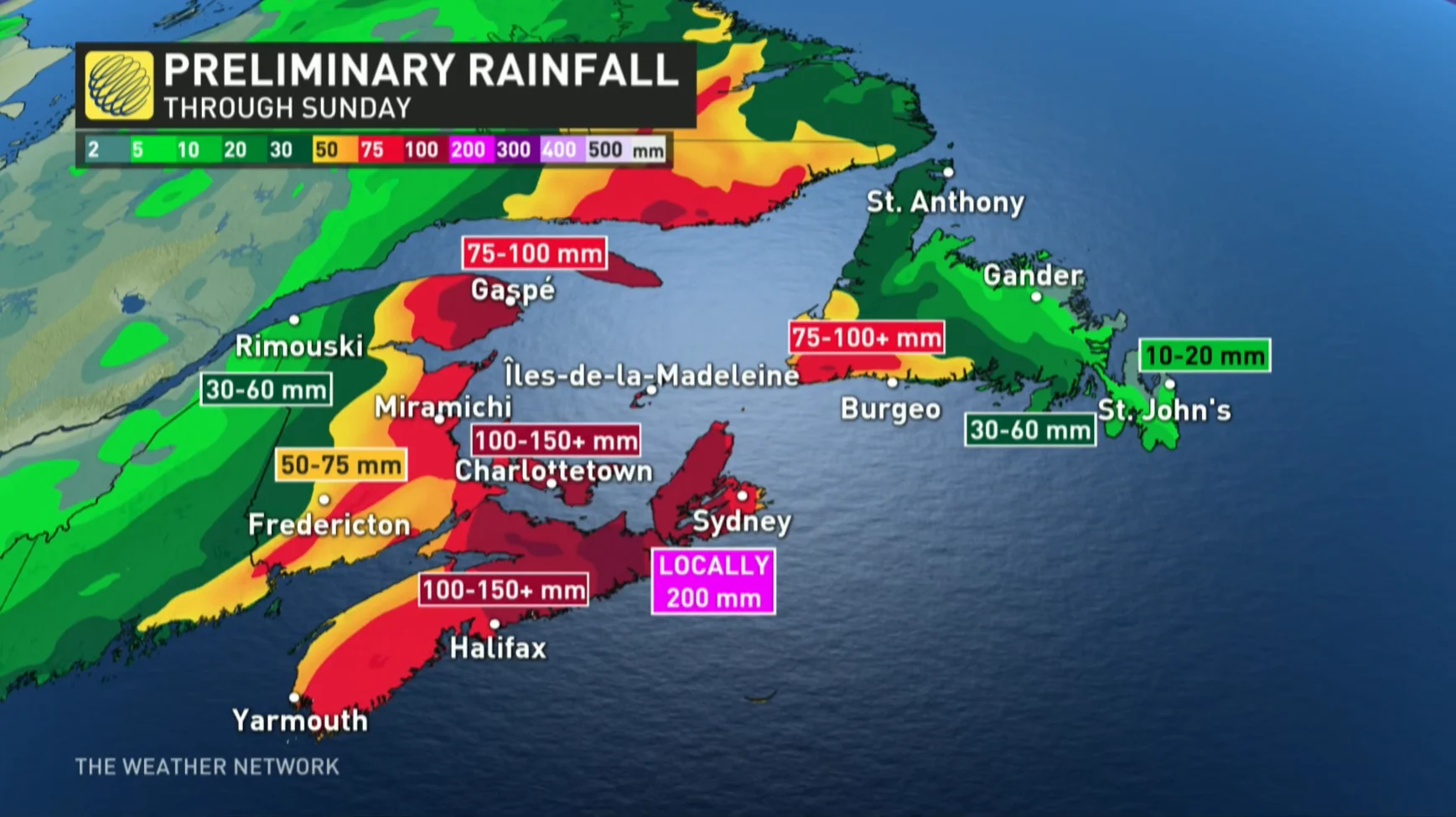
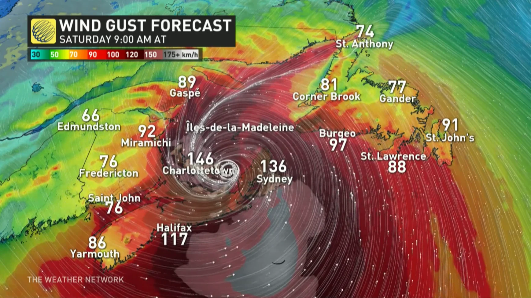
"Fiona will be a historic storm in Atlantic Canada, with locally over 200 mm of rainfall forecast. But almost more noteworthy will be the wind speeds and the pressure, likely below 940 millibars, which would make this a Canadian record," said Hamilton. "With strong pressure like that, wind gusts will be in excess of 140 km/h."
Because meteorological numbers like this are rarely seen, residents are urged to take Fiona and its impacts extremely seriously.
Meteorologists at the Canadian Hurricane Centre (CHC) said this could actually be Canada's version of Hurricane Sandy, referencing the size and intensity of Fiona and its combination of hurricane and winter storm characteristics. Sandy caused an estimated $78.7 billion in damage.
WATCH: What Nova Scotia can expect from Fiona over the weekend
Key impacts to expect as Fiona makes landfall
Widespread hurricane warnings and tropical storm warnings are in effect as Fiona approaches the region. Prepare to stay in a safe place until the storm moves on and conditions calm down.
Conditions will steadily deteriorate Friday night into early Saturday morning as the storm quickly approaches landfall. Forecasters expect Fiona to make landfall in eastern Nova Scotia early Saturday morning, making its way into the Gulf of St. Lawrence through the day on Saturday.
High winds and heavy rain will push through Newfoundland during the day Saturday, moving into Labrador through the overnight hours into Sunday.
Here’s a rundown of what you can expect as Fiona hits Atlantic Canada.
Rainfall warnings are in effect for much of the Maritimes, where forecasters expect the storm to produce a widespread swath of 100-200 mm of rain. Heavy rain could lead to flooding issues and road washouts in spots.
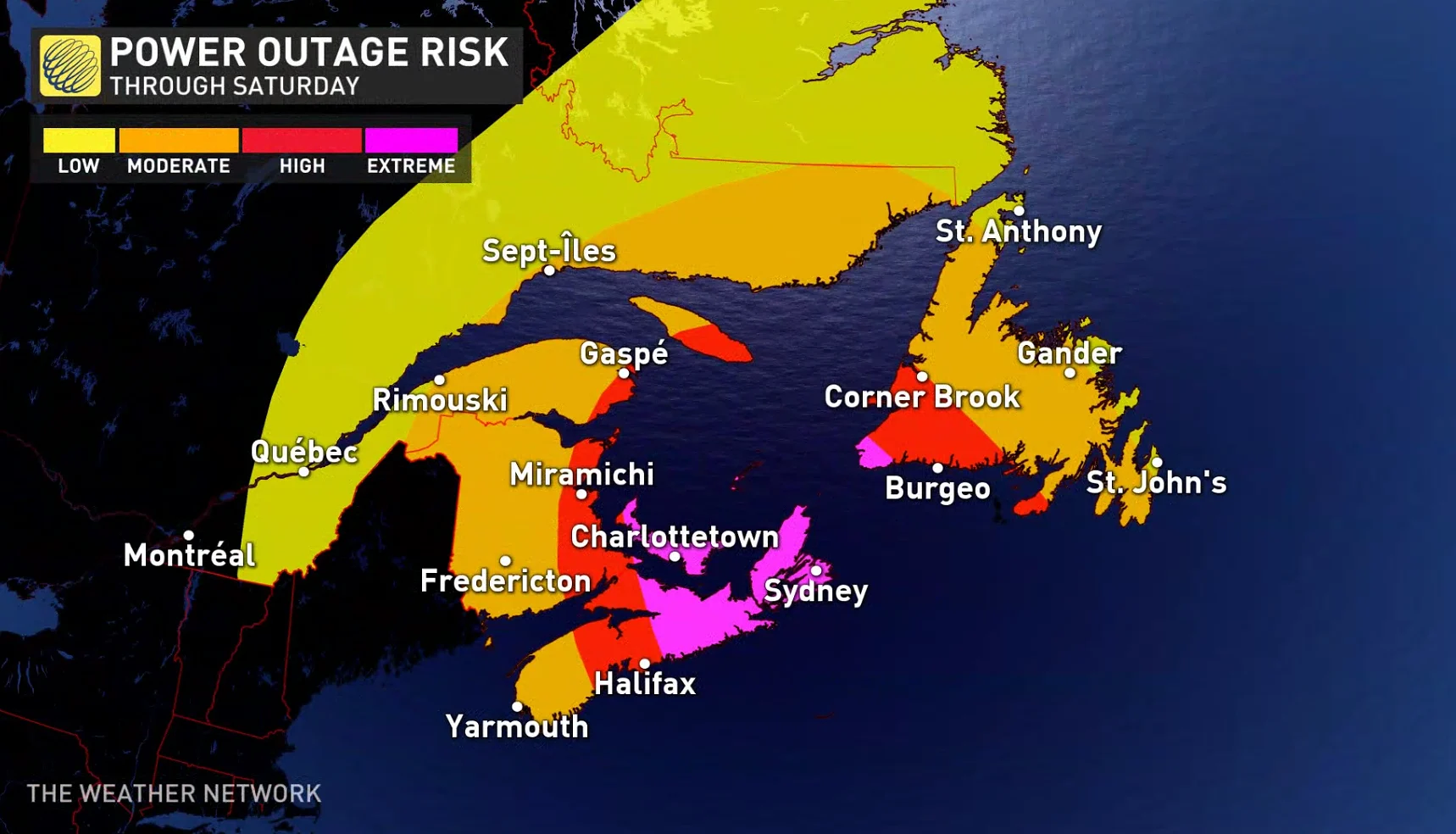
Very strong winds of 100+ km/h are expected as Fiona slams into the Atlantic provinces. These winds will lead to widespread power outages, especially in Nova Scotia and Prince Edward Island, where gusts could reach 150 km/h at the height of the storm.
Widespread power outages are expected as a result of the strong winds, heavy rain loosening the soil, and trees still in full leaf. These power outages could last for days in hardest-hit parts of Nova Scotia and P.E.I., causing a major disruption to day-to-day life.
Tree damage is likely in areas hit by the strongest winds. Trees falling into homes and cars is a leading cause of injury during landfalling storms. If you have trees or tree limbs near your home, avoid those rooms as much as possible during the storm. Make arrangements to sleep in a safer part of the house overnight when the strongest winds are expected.
RELATED: How to stay safe during a long duration power outage
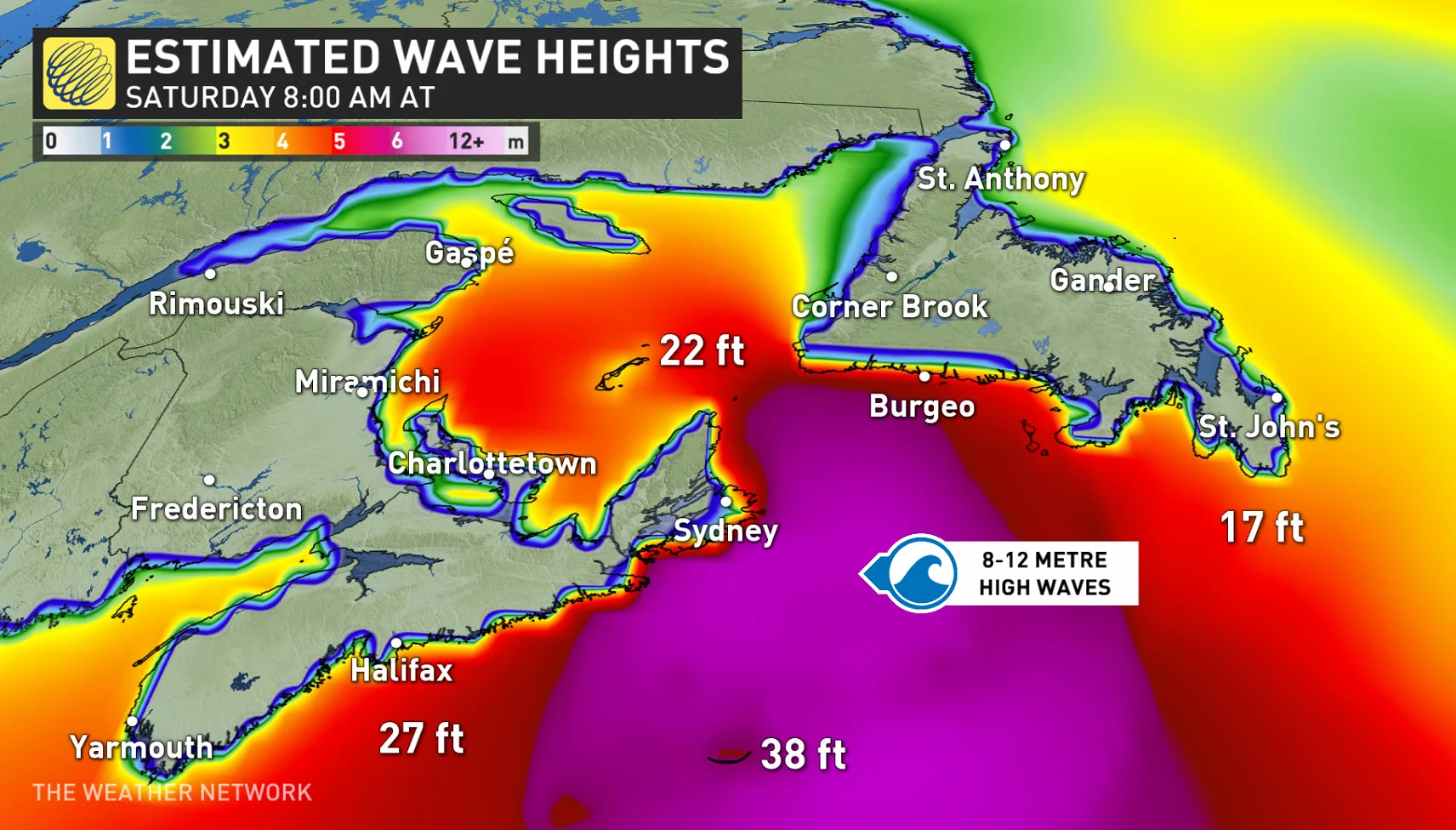
Storm surge and large waves will lead to coastal flooding for many spots across the Atlantic provinces. Waves could reach 12 metres at times in the Gulf of St. Lawrence and Cabot Strait, according to the CHC, and forecasters expect significant beach erosion across P.E.I.’s north-facing beaches.
A high danger for rip currents will exist through the weekend at just about every beach along the East Coast as a result of the high waves. Stay out of the water until local officials say conditions are safe again. If you ever find yourself in a rip current, calmly signal to the beach for help. If possible, swim parallel to the shore until the current releases you, then swim back to safety.
WATCH: 200mm of rain could fall in Cape Breton before Fiona is done
Residents, governments, and utilities are preparing for high impacts
Most preparations should be completed now that we’re within several hours of the storm’s worst winds and rain reaching Canadian soil.
Make sure you have an emergency kit ready to go in case it’s needed during and after the storm. Clear downspouts and storm drains to minimize the flooding potential. Ensure there are no loose objects around your home, such as lawn furniture and toys, that could become projectiles in high winds.
Authorities both across the region and in Ottawa are preparing for whatever Fiona sends their way.
Prime Minister Justin Trudeau announced Friday that the federal government was mobilizing resources to help communities affected by Hurricane Fiona this weekend.
WATCH: Small and exposed, how will Sable Island withstand Fiona's fury?
Nova Scotia Power activated its Emergency Operations Centre on Friday morning.
"Based on the recent weather forecasts, we are opening our Emergency Operations Centre Friday at 8am to ensure proper plans and crews are in place to manage our storm response," the company said in a press release.
P.E.I.'s Emergency Measures Organization (EMO) is activating to Level 1 enhanced monitoring and is encouraging Islanders to replenish supplies for up to five days, including food, water, heat and fuel supplies.
RELATED: How hot water fuels the world’s most powerful hurricanes
In Newfoundland's west coast city of Corner Brook, Mayor Jim Parsons said sandbags are already being filled, catch basins are being cleared and trees are being trimmed in anticipation of the hurricane-force winds.
Those with either air travel or ferry plans should expect restrictions and cancellations throughout the weekend. The Confederation Bridge is also warning of travel restrictions, starting later Friday night and lasting until early Sunday morning.
WATCH: These are the biggest impacts on your local area from Fiona
Stay tuned to The Weather Network for all the latest as Hurricane Fiona makes its final approach into Atlantic Canada.