How Hurricane Fiona's rare 'left hook' will make this a historical storm

Friday will be the final day for preparations as Fiona enters into Canadian waters and conditions rapidly deteriorate by Saturday morning.
The window of opportunity to prepare for Hurricane Fiona across Canada's East Coast is rapidly closing, with forecasters expecting the outer edges of Fiona to arrive in Nova Scotia and Prince Edward Island by Friday evening. Conditions will quickly deteriorate as the powerful storm approaches the region.
Hurricane safety: What to do before, during, and after landfall
The storm remained a powerful Category 3 hurricane on Friday morning, with the centre of Fiona passing to the northwest of Bermuda. It regained strength to a Category 4 storm once again, with maximum sustained winds at 215 km/h. Although gradual weakening is forecast, Fiona is expected to be a powerful hurricane-force cyclone when it moves across Atlantic Canada.
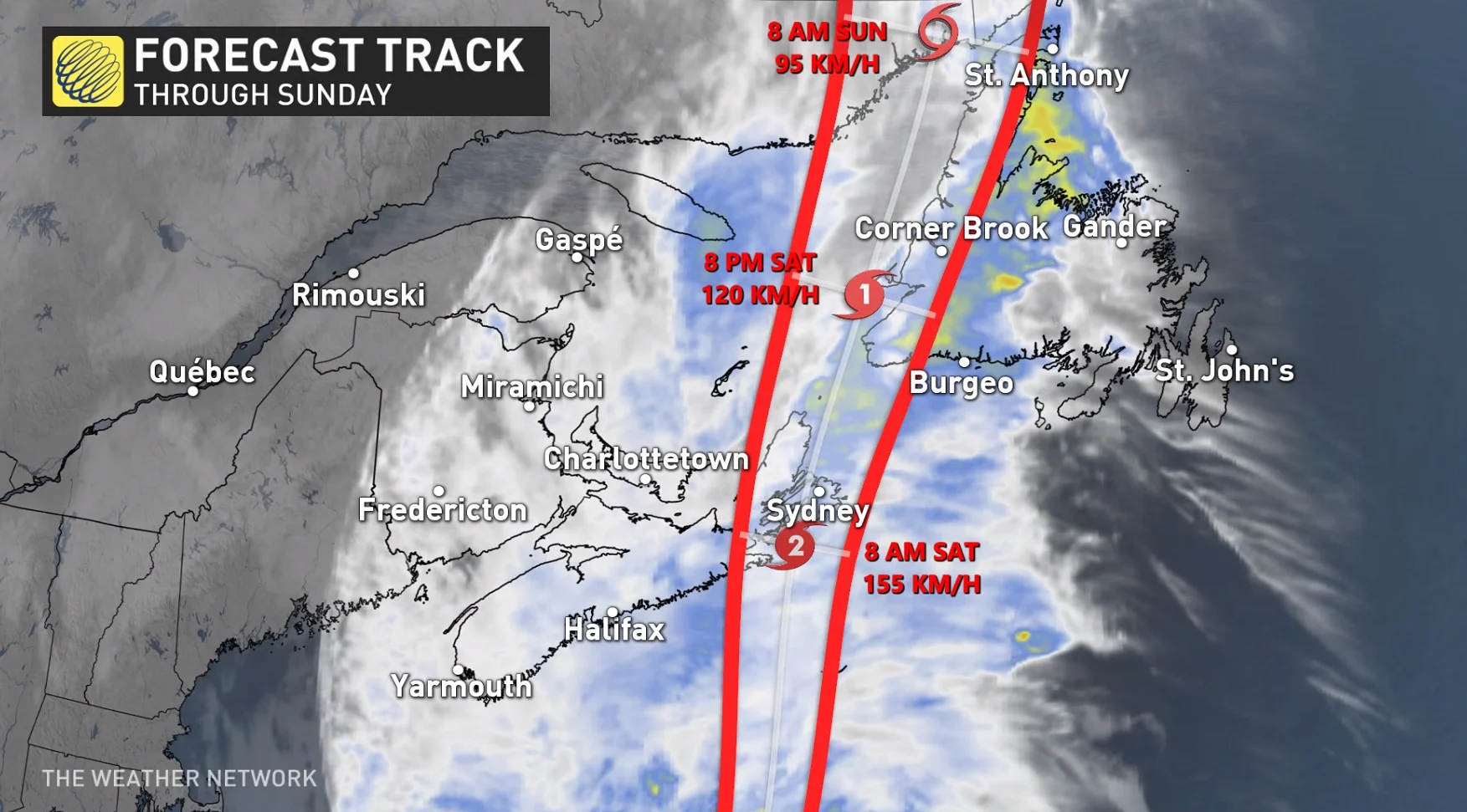
Fiona will hit Nova Scotia and P.E.I. with all its might Friday night and into Saturday morning, eventually reaching the Quebec lower North Shore and southeastern Labrador early Sunday.
"When looking at Fiona, you kind of get that sinking feeling in the pit of your stomach, and it's something as a meteorologist you don't get all too often," says Tyler Hamilton, a meteorologist at The Weather Network.
The track of Fiona is different in terms of how hurricanes have historically moved over the East Coast, and this one is not conforming to the standard. Any time you get a unique storm like this, you're going to get big damage.
DON'T MISS: Essential items for your emergency "grab-and-go" kit
"This is different. This track is going to hook left slamming into Nova Scotia," Hamilton says. "If you look through at least recent memory in recorded history, we don't have such a left hook type of track for such a strong low pressure system."
WATCH: Why Hurricane Fiona's 'left hook' will pack a serious punch
This is not just a hurricane either, it's more like a hurricane and a nor'easter combined. It's like comparing the intensity of Hurricane Juan, which was the most devastating storm to hit the Maritime provinces, combined with the size of Hurricane Dorian, a massive storm that set a record for the most people without power at one time.
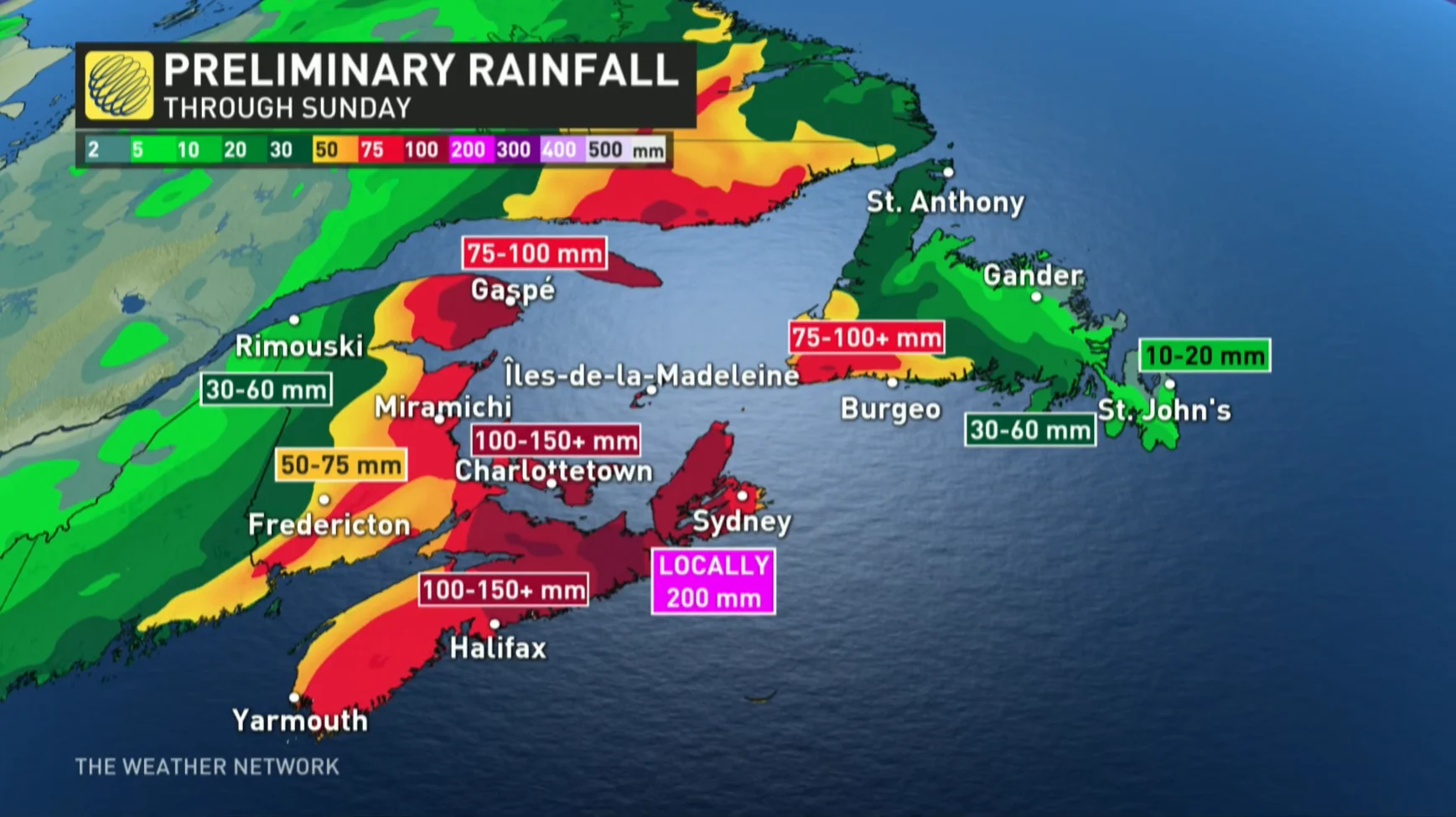
"Fiona will be a historic storm in Atlantic Canada, with locally over 200 mm of rainfall forecast. But almost more noteworthy will be the wind speeds and the pressure, likely below 940 millibars, which would make this a Canadian record," says Hamilton. "With strong pressure like that, wind gusts will be in excess of 140 km/h."
Because meteorological numbers like this are rarely seen, residents are urged to take Fiona and its impacts extremely seriously.
Meteorologists at The Canadian Hurricane Centre (CHC) said this could actually be Canada's version of Hurricane Sandy, referencing the size and intensity of Fiona and its combination of hurricane and winter storm characteristics. Sandy caused an estimated $78.7 billion in damage.
RELATED: How to stay safe during a long duration power outage
Fiona’s maximum winds will start to tick down as it approaches the Maritimes, but it will remain a large and powerful storm when it hits Friday and Saturday. Forecasters expect Fiona to continue producing widespread hurricane-force winds and wind gusts throughout Saturday, even after the system has lost its tropical characteristics.
Environment and Climate Change Canada (ECCC) issued a tropical cyclone information statement from the CHC and it covers the entire region. Hurricane and tropical storm warnings have also been issued, replacing the previous watches. A hurricane warning means that hurricane conditions are expected over parts of the region within 24 hours. Hurricane conditions include sustained winds near 120 km/h or more, and/or significantly elevated water levels and dangerous surf along the coast.
WATCH: Small and exposed, how will Sable Island withstand Fiona's fury?
Hurricane Fiona will continue on a northeasterly track that takes it past Bermuda through Friday. From there, an upper-level trough will grab the storm and pull it northwest toward Atlantic Canada.
This trough will help the storm transform into a large and potent post-tropical cyclone by late Saturday. Landfall is expected across eastern Nova Scotia by Saturday morning, where Fiona may remain a Category 1 hurricane.
Warm water temperatures in the western Atlantic are contributing to the storm’s strength. These waters are much warmer than normal, allowing the storm to maintain tropical characteristics and delaying its transition to extratropical cyclone status.
RELATED: How hot water fuels the world’s most powerful hurricanes
Fiona's Impacts: Brace for flash floods, long duration power outages
Rain: A widespread swath of 100-200 mm of rain is likely across parts of Atlantic Canada with Fiona, especially north and west of the track, where heavy rain could lead to flooding. The highest rainfall amounts are likely for eastern Nova Scotia, southwestern Newfoundland and the Gulf of St. Lawrence region. Road washouts and erosion are also possible.
Rainfall warnings now cover most of Nova Scotia, P.E.I. and southeastern New Brunswick, with rainfall rates in excess of 25 mm per hour possible in some places beginning Friday night.
Wind: High winds will cause major issues across the region. Gusts of 100+ km/h are expected as Fiona slams into the Atlantic provinces.
The system’s transition from a tropical cyclone to a post-tropical cyclone will expand its wind field, exposing a much larger area to strong winds.
Winds are strongest in the eye of the storm when it is a tropical system. As it starts to transition into a post-tropical storm, those strong winds start to expand throughout most of the system.
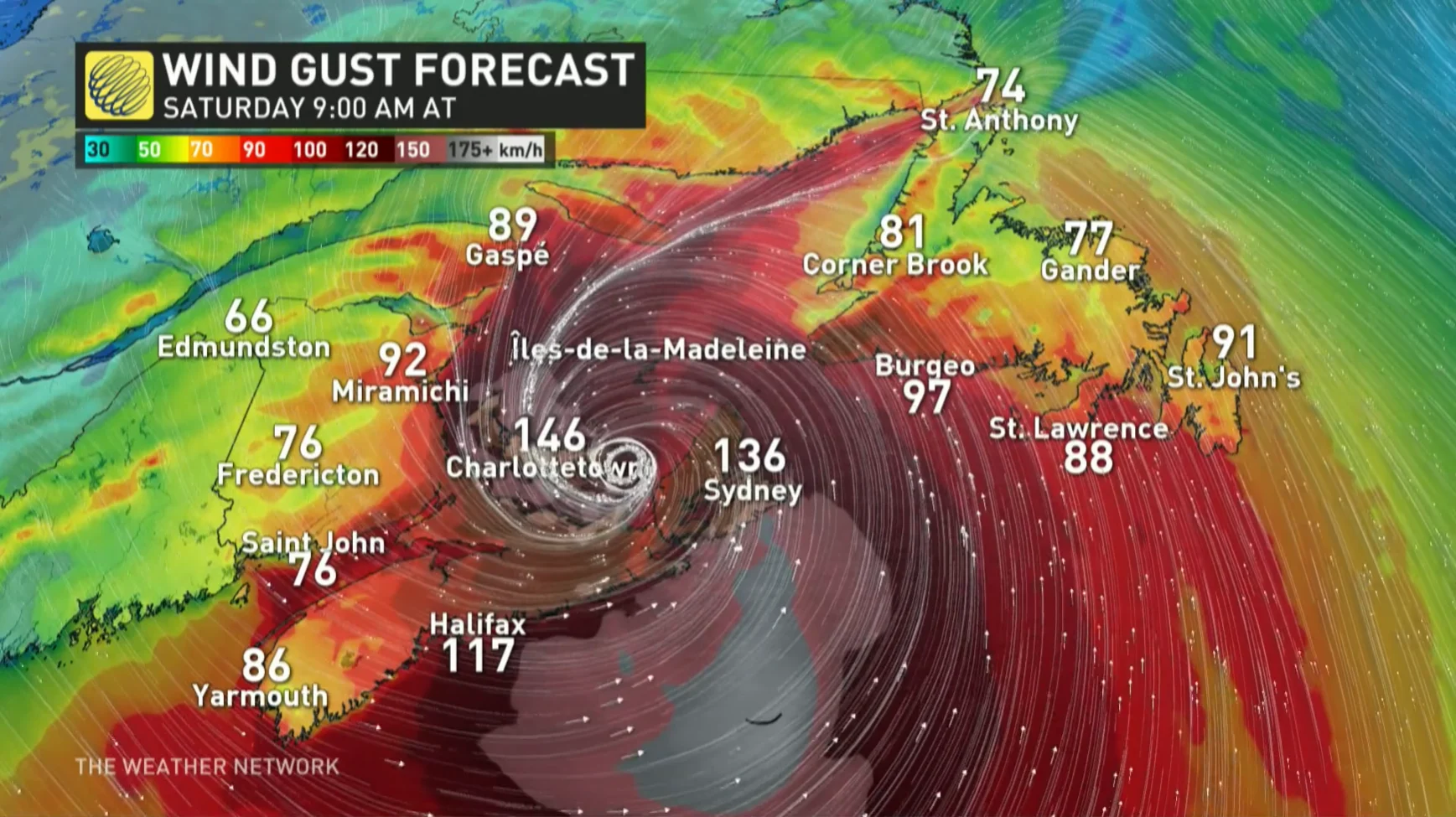
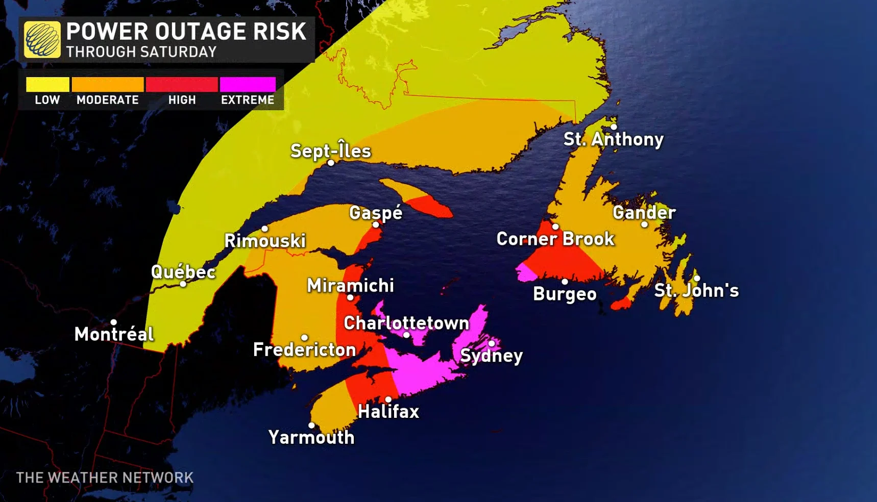
Even stronger gusts upwards of 150 km/h are possible for eastern Nova Scotia and P.E.I. With trees still in full leaf, there will also be a widespread risk of power outages across the region.
All of P.E.I. will see a prolonged period of very strong winds from the north and these gusts will likely gust in excess of 150 to 160 km/h. That will cause widespread power outages, likely for a longer period of time. These types of winds can lead to significant structural damage to buildings as well, causing windows to break and even tearing off large overhead highway signs.
According to Chris Scott, Chief Meteorologist at The Weather Network, "this is going to be a storm for the ages" for P.E.I.
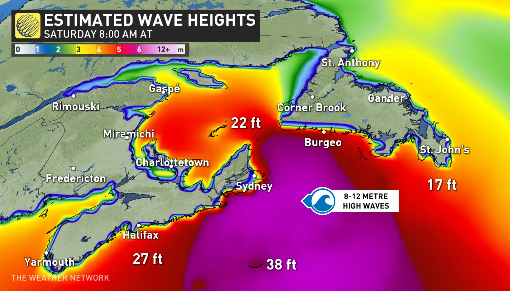
Surge and waves: There will also be some rough and pounding surf, especially for parts of Nova Scotia and Newfoundland. Large waves are expected to reach the eastern shore of Nova Scotia from the south on Friday, building to more than 10 metres before reaching southern Newfoundland Saturday morning.
"Some of the waves over eastern portions of the Gulf of St. Lawrence and Cabot Strait could be higher than 12 metres. The western Gulf will see waves from the north up to 8 metres in places, which will probably cause significant erosion for north facing beaches of Prince Edward Island," the CHC says. "Iles-de-la-Madeleine will also see some coastal erosion from waves."
The highest risk for coastal flooding will be a combination of storm surge with large waves moving onshore. For most areas, the highest water levels are expected near high tide some time on Saturday morning.
Residents are being urged to stay away from the shore as the combination of surge and large waves could result in dangerous rip currents and the risk of being pulled out to sea.
WATCH: What Nova Scotia can expect from Fiona over the weekend
With limited time left before impact, residents should be prepare. Making sure an emergency kit is ready, clearing downspouts and storm drains and having generators in working order, are all important factors to take into account.
Nova Scotia Power announced that the company will activate its Emergency Operations Centre at 8:00 a.m. on Friday.
"Based on the recent weather forecasts, we are opening our Emergency Operations Centre Friday at 8am to ensure proper plans and crews are in place to manage our storm response," the company said in its press release.
WATCH: 200mm of rain could fall in Cape Breton before Fiona is done
P.E.I.'s Emergency Measures Organization (EMO) is activating to Level 1 enhanced monitoring and is encouraging Islanders to replenish supplies for up to five days, including food, water, heat and fuel supplies.
In Newfoundland's west coast city of Corner Brook, Mayor Jim Parsons said sandbags are already being filled, catch basins are being cleared and trees are being trimmed in anticipation of the hurricane-force winds.
Those with either air travel or ferry plans should expect restrictions and cancellations throughout the weekend. The Confederation Bridge is also warning of travel restrictions, starting later Friday night and lasting until early Sunday morning.
WATCH: These are the biggest impacts on your local area from Fiona
Stay tuned to The Weather Network for the latest forecast details on Fiona's track and possible impacts on Atlantic Canada.