
Vehicles stranded as heavy rain swamps southern Ontario

Moisture from former Hurricane Barry helped fuel Wednesday's soggy weather, bringing morning downpours that triggered flooding severe enough to close several major roadways. Those storms produced a few funnel clouds in the Barrie area later by the afternoon, and a second round of pop-up showers in the southwest into the early evening. All this tropical moisture is also contributing to the unbearably high humidity levels with the greatest heat still yet to peak later this week. More on the rainfall timing, plus a look at how hot things will get, below.
WEATHER HIGHLIGHTS:
Toronto saw its rainiest day in over half a decade on Wednesday
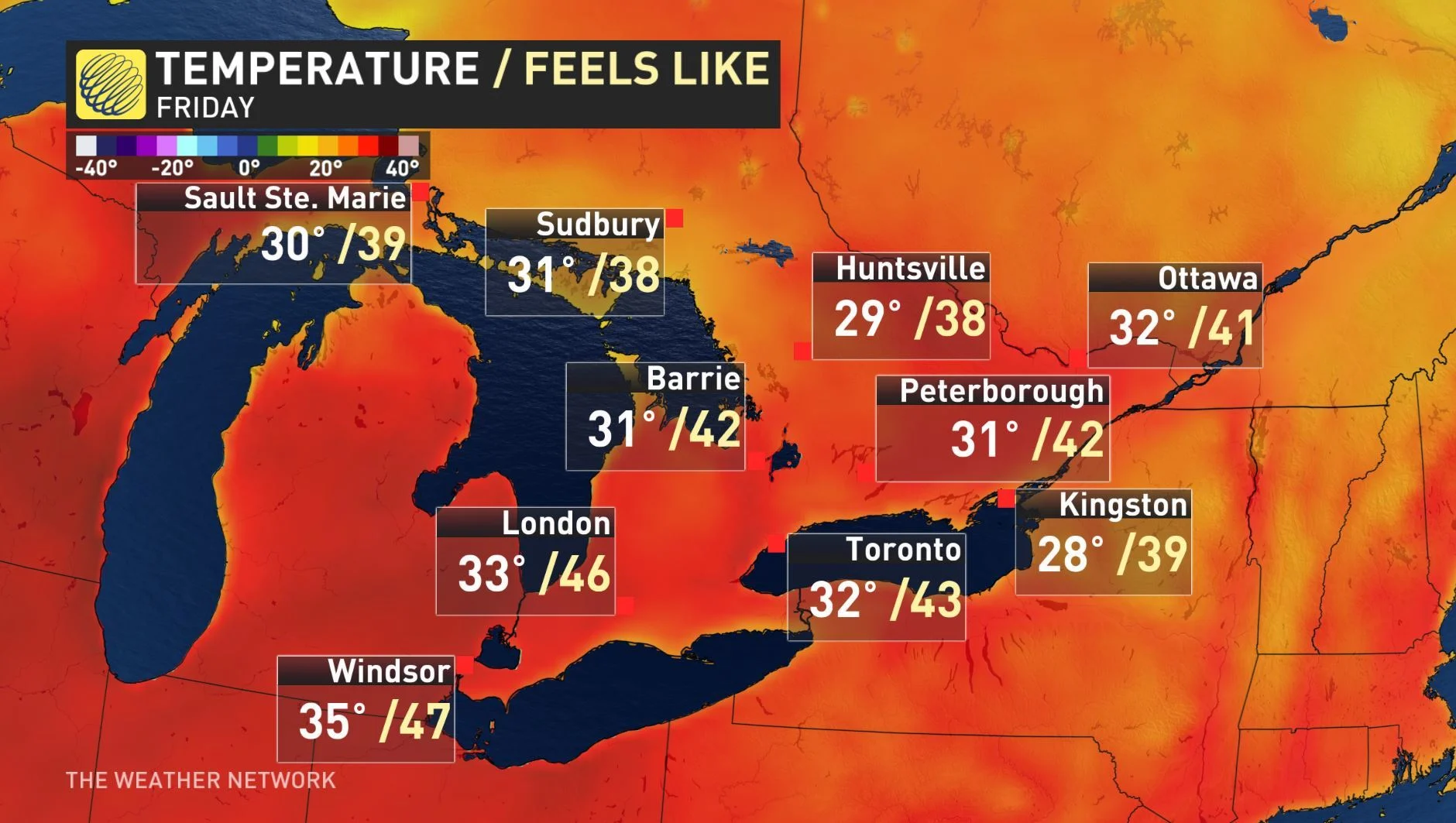
Heat and humidity last through the week across Ontario, many areas exceed the 30°C mark
Heat wave set to end by Sunday with the passage of a strong cold front
Stay up-to-date on the ALERTS in your area
FLOODING RAIN HITS SOUTHERN ONTARIO
The heaviest rain began across southwestern sections of the province early Wednesday, prompting a special weather statement for up to 40 mm of rain for areas from Niagara to south Lake Huron. That statement expanded to the Greater Toronto Area ahead of the morning commute, warning of locally heavy rain.
According to radar estimates, 50+ mm had already fallen across parts of the region before the lunch hour.
Flooding has been reported across the GTA with torrential downpours closing some major roadways in parts of the Toronto area. By 10 a.m., Kipling Avenue had been closed from Bethridge to Belfield roads as a result of the flooding and Rexdale Boulevard was also closed from Islington to Bergamot avenues. The Eastbound collector lanes to Islington Avenue on Highway 401 were also submerged in water.
Multiple vehicles were left inundated, with reports of some drivers forced to leave their cars completely stranded.
THUNDERSTORM THREAT
While the heaviest rain is expected to wrap up gradually during the early afternoon hours, the risk for thunderstorms will continue through the day and have the potential to unleash more heavy rain and flash flooding in isolated areas.
These storms are expected to be slow-moving and could even remain semi-stationary over the same areas, heightening a localized flood threat even further.
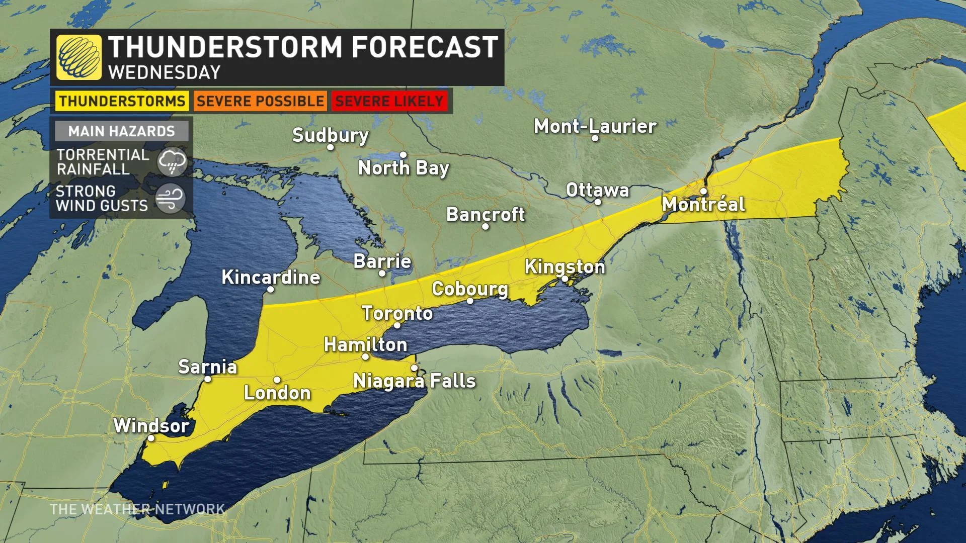
High pressure over northern Ontario will bring sunshine to the north and through cottage country on Wednesday as the northerly flow tries to push the boundary south.
This will also interact with a weak lake breeze along the north shore of Lake Ontario and possibly Lake Erie by mid-afternoon and will spark isolated showers and thunderstorms.
Several sightings of funnel clouds were reported in the Barrie area in the early afternoon, and Environment Canada issued a weather advisory saying more funnel clouds may be possible.
"These types of funnel clouds are generated by weak rotation under rapidly growing clouds or weak thunderstorms. This weak rotation is normally not a danger near the ground. However, there is a chance that this rotation could intensify and become a weak landspout tornado," Environment Canada says.
WATCH BELOW: TORONTO SAW ITS RAINIEST DAY IN OVER HALF A DECADE
More dangerous heat and humidity is expected to last through Friday and into the weekend as well, along with the risk for a passing thunderstorm with stronger storms possibly producing more torrential rain.
HUMIDITY PEAKS AT DANGEROUS LEVELS
"The heat will peak on Friday and Saturday with truly tropical humiditly. This will give us a dangerous humidex reaching the low to mid 40s," warns meteorologist Dr. Doug Gillham.
Gillham adds that the overall pattern heading into the weekend will bring the threat for scattered strong to severe thunderstorms with more widespread rain and strong winds.
RELATED: Five horrible things extreme heat does to the human body
Although the exact timing is still uncertain, the heat wave is expected to end by late Sunday as a cold front puts a bold halt on the muggy weather. A final round of thunderstorms is likely as the front approaches the region bringing much cooler and les humid conditions for the start of the new work week.
"A pattern change early next week will bring an extended period of cooler weather (near seasonal and at times cooler than seasonal) for the final week of July and likely continuing at least into the first week of August throughout the Great Lakes region, including southern Ontario," Gillham says.
Be sure to check back for the latest forecast and storm updates as they develop.


