Mighty winds in B.C. threaten power outages with looming soggy systems

The Pacific coast will be in for a rough ride through Thursday, as vigorous lows are set to bring significant amounts of rainfall and some howling wind gusts, which may be enough to knock out power and down trees in some areas.
The next couple of days will be quite stormy for parts of B.C., as multiple soggy systems will channel their way in from the Pacific. The first wave will arrive Tuesday overnight, followed by the second in the evening hours Wednesday. Hefty rainfall amounts are anticipated, depending on location and terrain, with 100+ mm not out of the question for some. The winds will also be a significant issue come Wednesday evening and beyond, particularly for the Haida Gwaii, with 100 km/h gusts expected. Those living in the hardest-hit areas should be prepared for possible power outages and winds may also knock down trees. By the end of this week, many areas will see their normal rainfall for the entire month of September or even surpass their monthly records. More on the timing and impacts, below.
WEDNESDAY/THURSDAY: MORE HEAVY RAIN, POWERFUL WIND GUSTS COULD BRING POWER OUTAGES
The first of two lows will move in Tuesday overnight, ushering in a bout of heavy rainfall for the coastal sections of B.C., spreading into the Lower Mainland for early Wednesday morning.
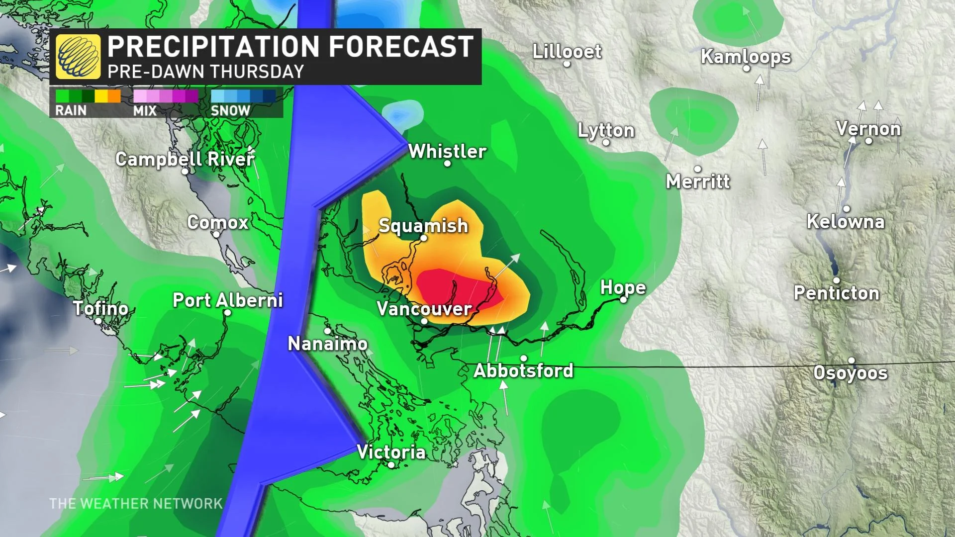
The heaviest rain for southern British Columbia will come with the second system pushing in Wednesday evening, continuing through early Thursday morning. Precipitation rates will peak through the overnight hours and into the pre-dawn on Thursday.
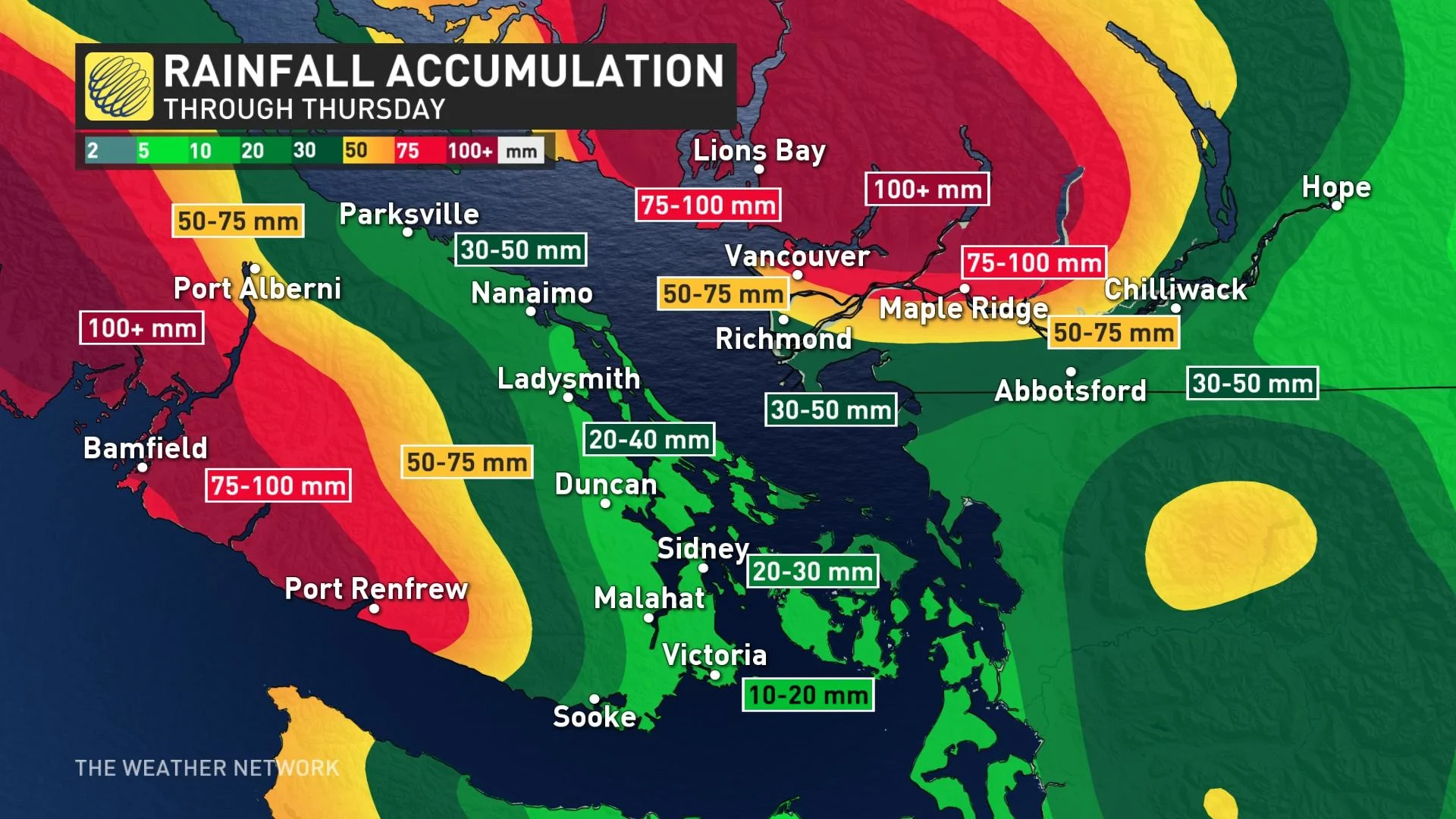
Rainfall totals with these two systems will be highly dependent on terrain and location, with areas north of the Fraser Valley having the best chance for higher totals in the 75-100 mm range, through Thursday.
Most of Metro Vancouver will be on the cusp of 50-75 mm, but southern areas could be in the 30-50 mm range. Western Vancouver Island could rack up totals over 100 mm by the time it moves out.
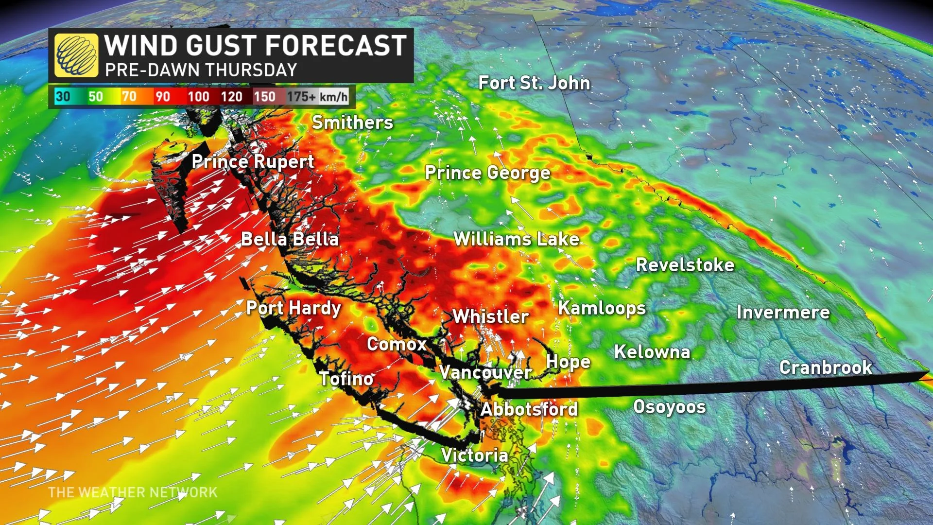
In addition to the soaking rains, winds will also be an issue, with the strongest gusts targeting northern areas, closer to the surface low.
Wind gusts will exceed 100 km/h for Haida Gwaii, as well as the North and Central coasts. The Strait of Georgia and Juan De Fuca to see gusts hit 60-90 km/h Wednesday overnight. Less blustery conditions are anticipated for the Lower Mainland, with wind gusts of 40-60 km/h, but will be slightly stronger along the shorelines.
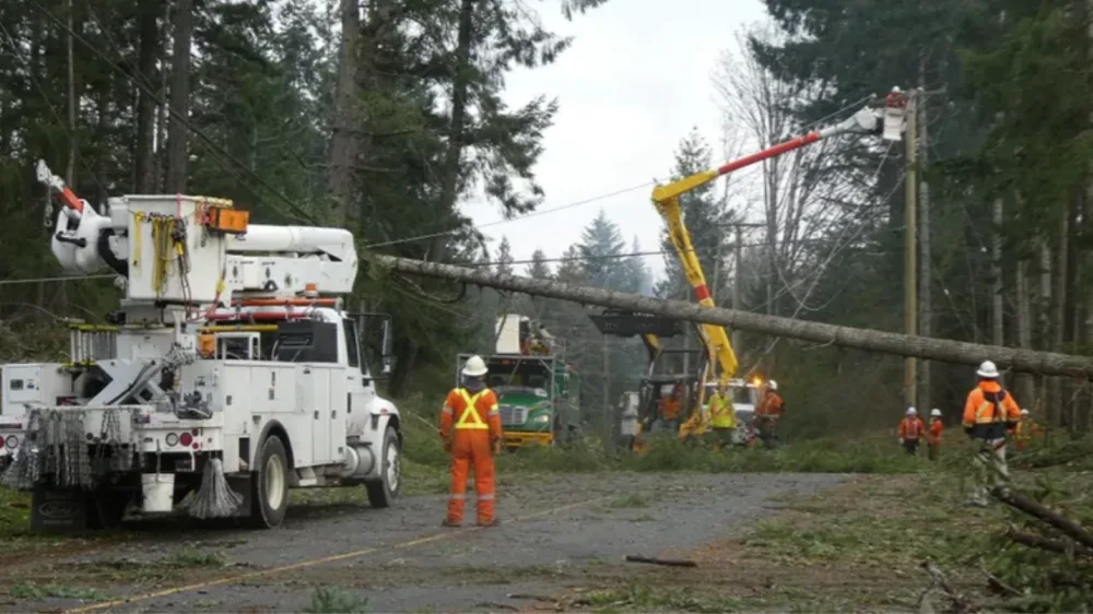
The areas seeing the strongest wind gusts could experience power outages and downed trees.
By the week's end, many areas along the coast and inland have the potential to see 100-200 mm of rainfall. These additional amounts could allow some locations to break their monthly rainfall records for September.
LAND SLIPPAGE PROMPTS EVACUATION ALERT
A land slippage in the vicinity of Frizzi Road and North Mackenzie Avenue has prompted the City of Williams Lake to activate its Emergency Operations Centre at Level 2.
As a precautionary measure, the Green Acres Mobile Home Park has been placed on evacuation alert. The city has notified all relevant agencies and is working with Emergency Management BC to address the situation as it evolves.
As well, a state of local emergency has been declared to allow the city to undertake extraordinary measures to respond to and limit any damage.
LOOK AHEAD: DRYING OUT FOR THE WEEKEND AND BEYOND, GORGEOUS EARLY FALL WEATHER
A much drier pattern is expected to filter in Friday and continue on the weekend and for most of next week.
An extended stretch of gorgeous early fall weather is on the doorstep for southern B.C., with temperatures near or a few degrees above seasonal.
Thumbnail courtesy of BC Hydro/Twitter.
Check back for updates on this soggy end to September in B.C.