Ontario: 'Snowy surprise' kicks off November, powerful winds threaten big waves

Wicked winds and a swath of snow will kick off the start of November in Ontario
After what was a messy, rainy Halloween, November kicks off with lingering strong winds making power outages and shoreline flooding possible, along with some snow -- a brief, short-lived burst for parts of the south, and a more powerful wallop for parts of the north. More on the timing and impact, below.
WEATHER HIGHLIGHTS
Strong cold front with damaging wind gusts still ongoing Friday
Burst of at-times heavy snow for parts of the north, some flakes for parts of the south
Chilly weekend weather and bands of lake-effect snow north of the GTA into Sunday
Stay up-to-date on the ALERTS in your area
WATCH BELOW: WHERE TO EXPECT FRIDAY MORNING'S STRONGEST WINDS
The downpours that marked Halloween will be largely ended for most people in southern Ontario Friday as the powerful system that produced them moves on to Quebec.
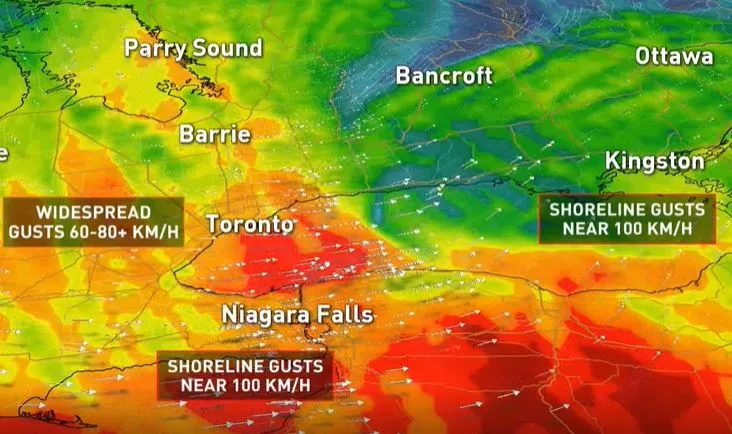
But that same system will still pack a punch, in the form of lingering strong winds. For the southwest, the strongest gusts will have eased from their overnight peak, but may still be blowing up a storm for parts of the Niagara Region and the coastal GTA as they gradually move eastward through the morning.
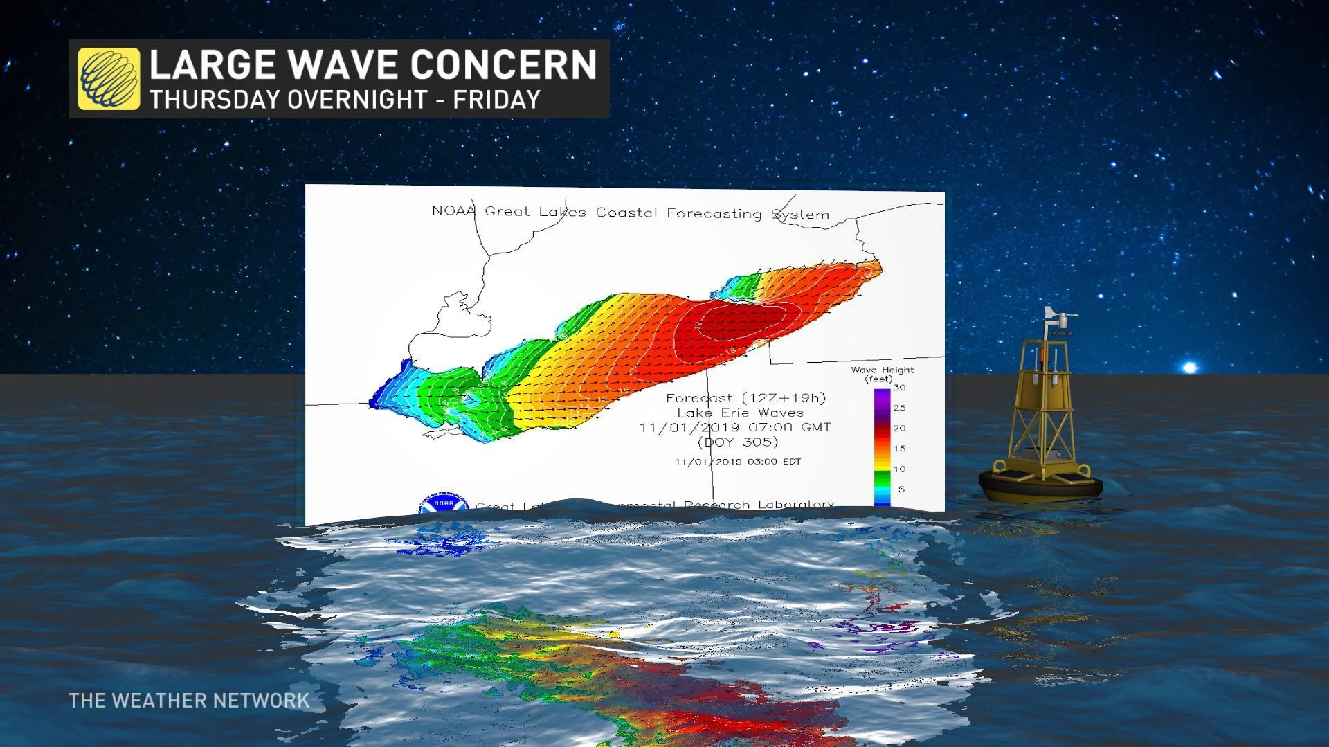
Those winds should have people along the shore on the alert: They'll whip up the waters of Lake Erie and Lake Ontario with very high winds by the morning.
That would ordinarily be concern enough, but with the ground still moist from last weekend's heavy flooding rain, the winds and the fresh-fallen rain will make coastal flooding even more likely.
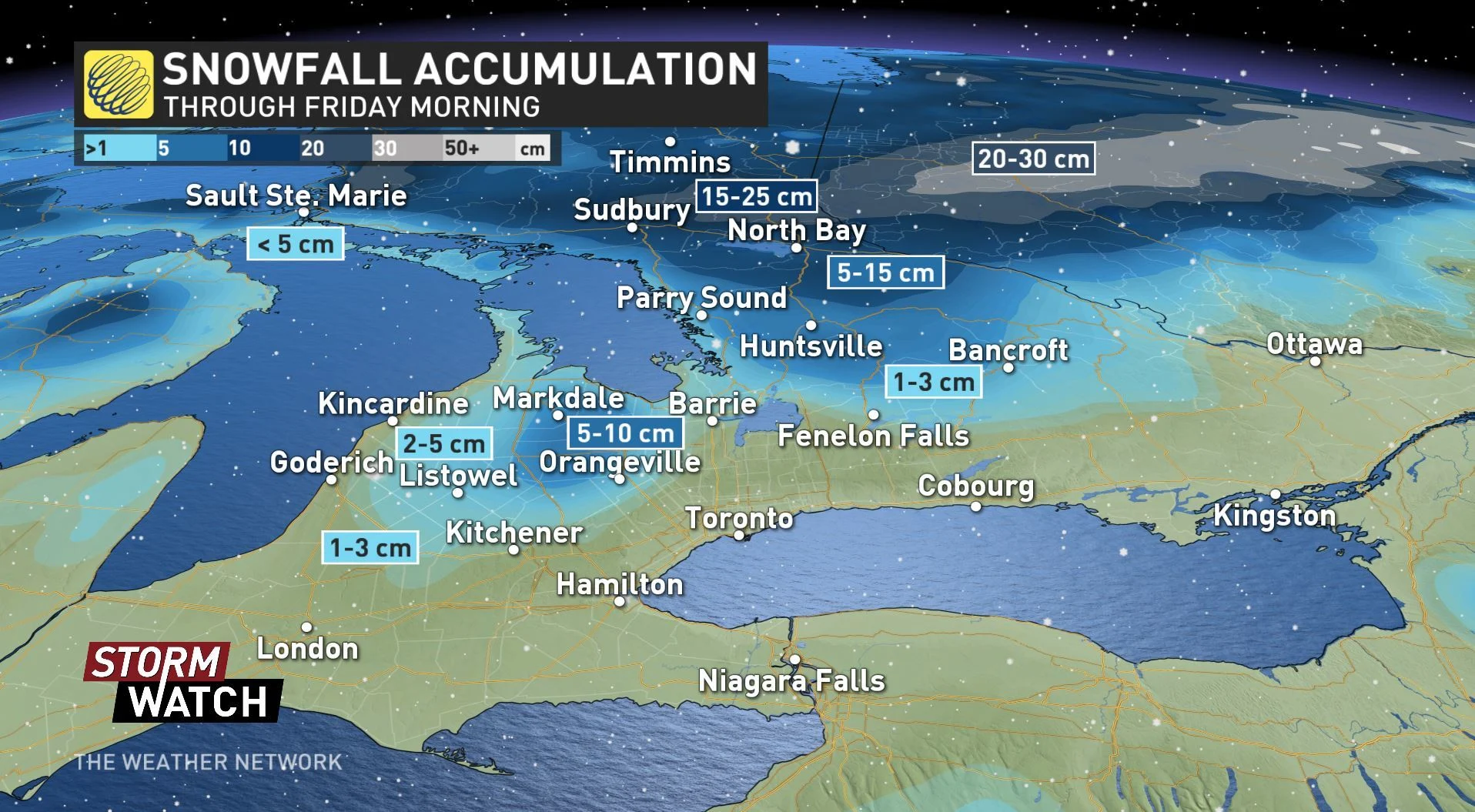
The system that will have passed through the province by the morning will have manifested as heavy snow for areas further to the north, with up to 25 cm expected for some. However, there are parts of the south which may also wake up to some flakes.
"No accumulation is expected across much of the Greater Toronto Area, but a coating of wet snow is likely across the higher elevations north and west of the GTA, including Orangeville and the Kitchener and Waterloo region, which may catch some people off guard," says Weather Network meteorologist Dr. Doug Gillham.
SEE ALSO: Canada's got some freaky fall frost stats
Colder than average temperatures will lock in for at least the first week of November, with a threat for significant lake-effect snow in the traditional snowbelts.
According to Gillham, some computer models also show the potential for a widespread system snow by late next week.
"We are closely monitoring this potential, so be sure to check back for updates," he adds.