East Coast cleanup continues as Newfoundland sees flooding, hard freeze risk

As Nova Scotia continues to deal with efforts to restore power to tens of thousands after a potent ice storm, Newfoundland is in the midst of its own problems from the same system -- flooding and a sharp temperature drop that threatens a hard freeze into Sunday.
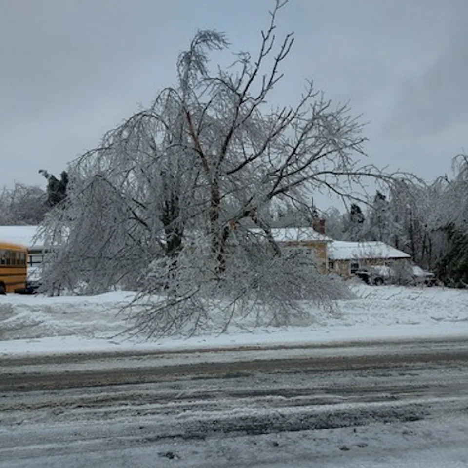
Tens of thousands of people in Nova Scotia remain in the dark Saturday after 18-24 hours of freezing rain took a toll on trees and power lines across the province. While the freezing rain has since subsided, the restorative electricity efforts will be ongoing through the remainder of the weekend and possibly into next week as strong winds could hinder the attempts to fix them. Newfoundland, meanwhile, is in the midst of its own problems from the same system -- heavy rain, snow, flooding and a sharp temperature drop that threatens a hard freeze into Sunday. More on the Nova Scotia and Newfoundland storm impacts, and what's left for the remainder of the weekend, below.
DON’T MISS: PHOTOS: Thousands without power on the East Coast amid dynamic winter storm
BREEZY CONDITIONS AND SUBFREEZING TEMPERATURES ADD INSULT TO INJURY
Even though freezing rain came to an end in Nova Scotia, the issues are far from over. Extensive ice buildup will weigh down trees and power lines until temperatures climb back above freezing next week.
Wind gusts of 30-50 km/h will linger into Sunday morning, adding additional stress on top of the weight of the ice, leading to the potential for more downed trees and power outages into early this week.
Even if your power remained on through the ice storm, it’s a good idea to prepare for outages through the weekend as trees and lines buckle under the stress.
Keep your devices as fully charged as possible over the next few days. If the power goes out, avoid using your device unless absolutely necessary. If you have flashlights, put them in an easily accessible spot (along with extra batteries) so you can find your way around in the dark without relying on a smartphone’s flashlight feature.
Also, make a note of any tall trees or large tree limbs that could fall into your home if they’re weighed down by significant ice accretion. Trees falling into homes is a regular source of injuries during and after winter storms. If there’s a tree that looms large overhead, consider avoiding those rooms until the ice falls or melts.
STAY PREPARED: How to stay safe during a winter power outage
NEWFOUNDLAND SEES SNOW, FLOODING THREAT THEN HARD FREEZE
Temperatures have been warm enough to keep much of the Avalon and Burin peninsulas straight rain for the bulk of this system. Freezing rain did push through, as well, with a decent amount of ice accretion, which will subside in the overnight hours Saturday once the colder air moves in.
Rain, at times heavy, will change to snow after midnight. The snow will taper off Sunday morning.
Some of the highest rainfall totals are likely to occur over an area previously affected by flooding last weekend. Flooding and road washouts are possible once again.

An additional 50-75 mm of rain is expected for parts of the Avalon by the time the system wraps up, 30-50 mm earmarked for communities just north of the peninsula.
The deluge has created more flooding across the Avalon, where we dealt with flooding issues just last weekend.
Newfoundland’s Department of Transportation and Infrastructure tweeted on Saturday that rising waters had already covered a highway on the Avalon Peninsula.
Environment and Climate Change Canada (ECCC) mentioned the risk for flooding in its rainfall warning for the region.
“Heavy downpours can cause flash floods and water pooling on roads,” the agency said in the warning.
Meanwhile, snow will continue over central Newfoundland Saturday overnight then subsiding Sunday morning. Forecasters expect an additional 10-20 cm of snow, with the highest totals in, west and south of Gander.

Minor accumulations are also possible on the Avalon and Burin, with less than 5 cm possible in St. John’s as rain changes over to a quick dose of snow at the end of the storm.
WATCH: DAMAGING ICE STORM KNOCKS OUT POWER TO THOUSANDS IN NOVA SCOTIA
FRIGID TEMPERATURES FLOOD IN BEHIND THE STORM
Arctic air will finally win out as the boundary moves away from the region and allows colder air to spill in from the north. Widespread low temperatures in the negative double digits are likely across the Maritimes by Sunday morning, with a repeat possible on Monday morning.
St. John's, N.L., can expect to see a huge plummet in temperatures, going from close to 10°C Saturday evening to -8°C by Sunday morning. The wind chills will be even colder, feeling like -18. The sharp drop in temperatures will bring the risk of a hard freeze from any standing water leftover from the heavy rains.

Temperatures this cold will make things especially difficult for folks dealing with extended power outages. Seal up any windows and doors that could let out excess heat. Never use grills, generators, or outdoor heaters indoors or too close to a structure. This kind of misuse could lead to a life-threatening risk for carbon monoxide poisoning.
Not only will the cold pose a challenge to those who lost electricity due to the freezing rain, but frigid temperatures will cause standing water to freeze hard. Any wet roads and sidewalks will turn into a skating rink this weekend. Use extra caution while driving or walking over the next couple of days.

Temperatures should climb to or above freezing for much of the Maritimes by early next week, which will help melt the ice and aid in cleanup efforts. However, we’re looking ahead to the potential for another storm to arrive by Tuesday morning. The track is still highly uncertain right now, so it’s too soon to say what impacts the system will have on the region.
Thumbnail courtesy of Jack, taken in Lower Sackville, N.S.
Stay with The Weather Network for all the latest on the forecast across Atlantic Canada.