
Sorry snowbirds, parts of Canada are warmer than Florida next week

It is snowing across many provinces in Canada this week and the cold air mass could pay an unwelcome visit to snowbirds in the southern U.S., including Florida this weekend.
No Canadian wants to drive all the way down the interstate from a cold Canada only to find out it's equally cold in the southern U.S. That is what could unfold for many hoping to seek out some sunshine and beach weather the next few weeks in the Sunshine State.
WHAT'S CONSIDERED NORMAL FOR FLORIDA THIS TIME OF YEAR?
The average high for November in Pensacola, Florida, is about 21ºC, and the typical overnight low is around 12ºC. With a cold shot of air on the way later this week, the area could go down to the freezing mark during the overnight by early next week. That's not quite record-breaking, but still notably cold for this early in the season.
Several rounds of cold air will get reinforced by mid-next week. If you are or plan on vacationing farther south in the Sunshine State, the cold will not be as extreme, though you might want to pack your jacket. Areas like Orlando and Tampa will be looking at afternoon temperatures near 20ºC by the middle of next week, too. Overnight lows will stay much warmer than in the Panhandle, however, keeping the risk for freezing air at bay.
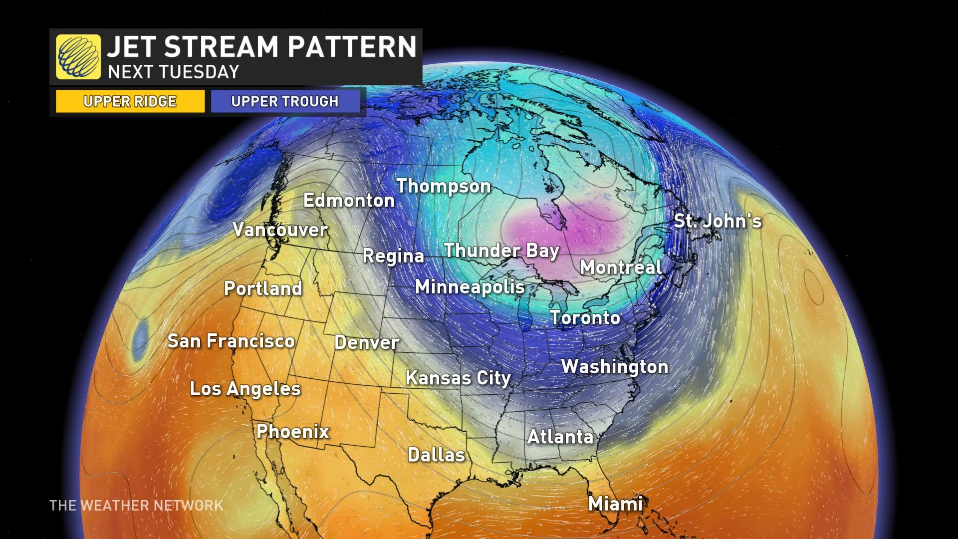
COULD IT REALLY BE WARMER IN CANADA THAN FLORIDA NEXT WEEK?
The short answer is yes -- you might get bragging rights in you live in parts of Alberta or B.C. But there's a catch.
As Arctic air plunges south early next week, overnight temperatures across northern Florida will flirt with the freezing mark, while a ridge in western Canada will give daytime temperatures in parts of Alberta and B.C. a boost.
If we compare overnight to overnight, however, Florida is still likely to come out ahead, as lows in southern Alberta and B.C. are expected to drop closer to -5ºC while Pensacola hovers right near zero. Still, it's a lot closer than you'd expect the two places to be, particularly at this time of year.
The jet stream is to blame for the unusual weather. The ribbon of air in our upper atmosphere is responsible for separating the warm air and cold air. This air mass will be coming across the North Pole and into Canada first, before modifying slightly and pouring into the southern U.S.
The cold will spill into other parts of the south, including Atlanta, Georgia, where overnight lows close to -6ºC are possible early next week.
PATTERN WILL BE COLD ENOUGH FOR SNOW
As cold air collides with warmer air as it digs south, that will set the stage for several rounds of active weather into the long range, including shots of lake-effect snow for the Great Lakes region.
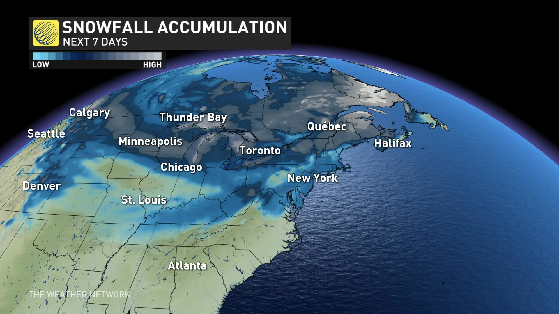
Early forecast models also suggest the potential for snow in Tennessee and the Mid-Atlantic region, as well as up into New England and Atlantic Canada over the next seven days.
Thumbnail: Frozen fountain in Pensacola, Florida. Image courtesy Sarah Smith, Jan 9 2010.


