
Stationary low brings prolonged rainfall, flooding risk on East Coast

Blocking in the North Atlantic is allowing for slow-moving or even stationary systems to dump abundant amounts of rainfall to Atlantic Canada this week, along with fierce winds. More than 100 mm of rain is possible over the hardest-hit areas through Wednesday. As a result, widespread rainfall and wind warnings are in place, along with special weather statements, highlighting the risk of flooding as a result and cautioning motorists of the road conditions. More on the timing and impacts, below.
TUESDAY-WEDNESDAY: HEAVY RAIN PUSHES EAST, INTENSE WINDS, HEIGHTENED FLOOD THREAT
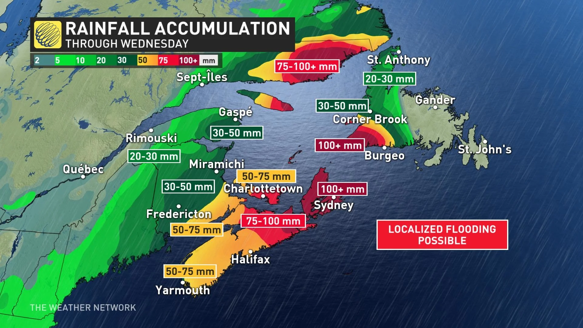
Much of the Maritimes are seeing a tremendous amount of Gulf and subtropical moisture as mulitple systems move across the region this week. Localized flooding will remain a concern, along with intense winds, through Tuesday.
Rainfall and wind warnings, along with special weather statements blanket much of the Maritimes and parts of Newfoundland.
Halifax will see its heaviest rainfall persist through the overnight hours Monday, then easing Tuesday afternoon as the core of it will be focused over Cape Breton, while also pushing into western Newfoundland during this time.
RELATED: How to prepare for this week's rainstorm
As a result of the multi-day event, rainfall amounts will be extreme for all of Nova Scotia, with areas east of Halifax and the heart of the province expected to see 75-100 mm. Cape Breton could see 100+ mm. Halifax and areas west, and north, could see 50-75 mm, as well as southern New Brunswick. Coastal areas of western Newfoundland may see 100+ mm of rain, with lesser amounts as you head farther inland and northward along the island.
"There is the potential for localized flooding, flash floods and water pooling on roadways. Travelers should expect to encounter adverse driving conditions," Environment and Climate Change Canada (ECCC) warns.
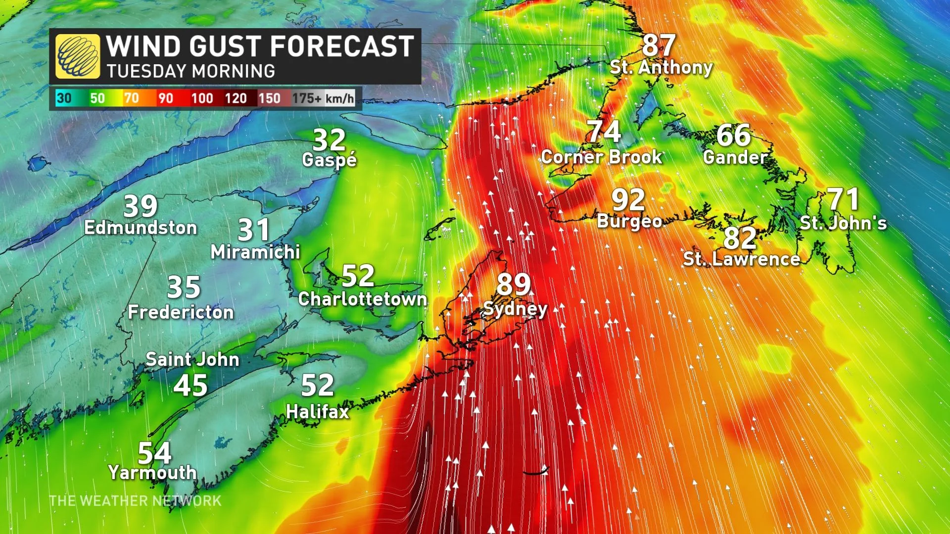
Strong southeasterly winds will continue to strengthen Monday overnight, gusting 60-80 km/h, but areas along the Atlantic coast and over exposed areas could see gusts as high as 100 km/h. Winds will begin to subside through the day Tuesday.
Pounding surf and higher than normal water levels are possible Tuesday and Wednesday.
LOOK AHEAD: TEMPERATURES DROP, FREEZING RAIN, ICE RISK ALONG WITH MORE RAIN
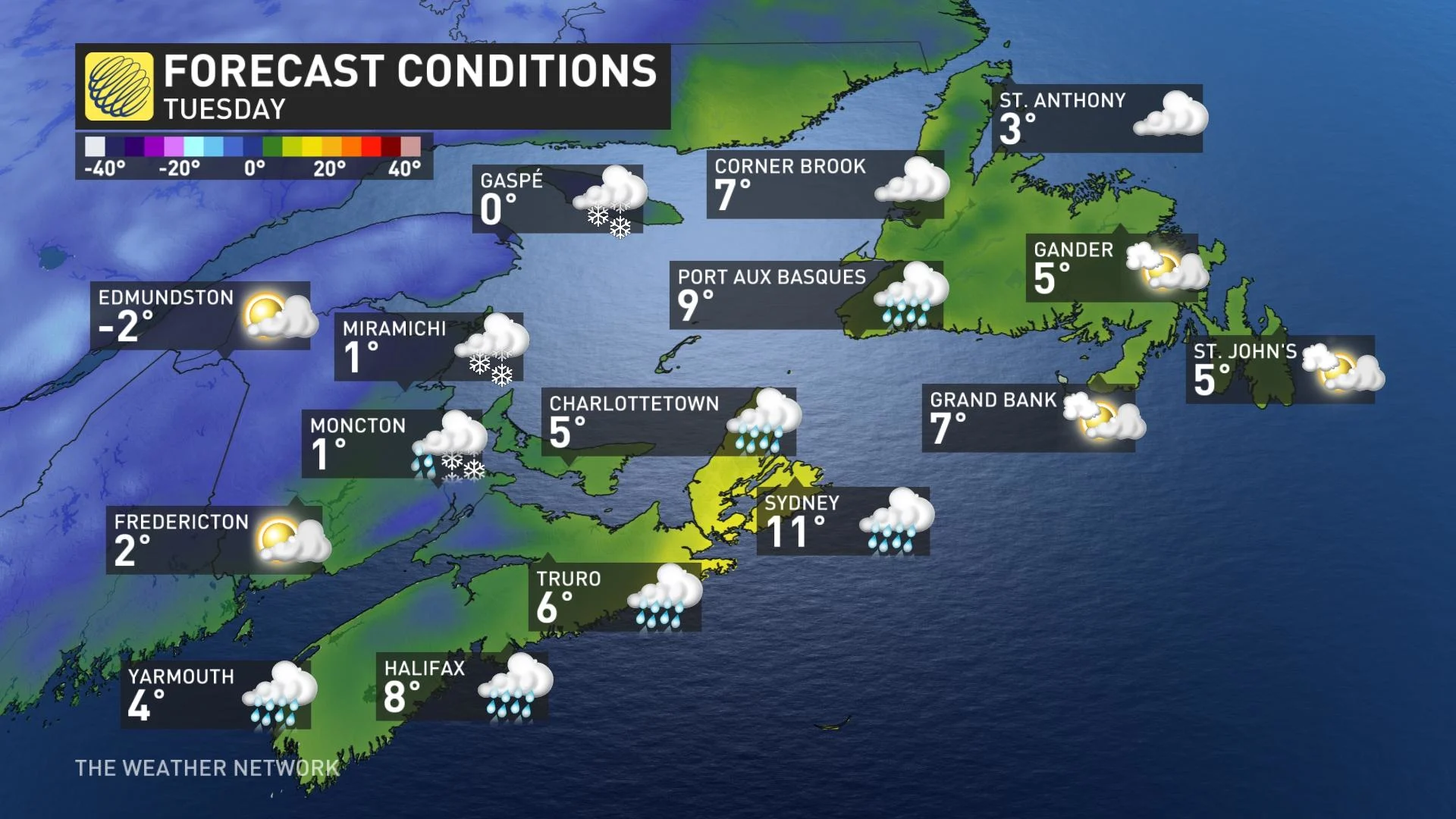
By Wednesday, a strong blocking high across the east will force this system to retrograde, essentially move backwards from east to west, continuing to impact much of the Maritimes with ongoing rain.
Temperatures in the Maritimes will drop drastically in behind the frontal boundary Tuesday overnight into early Wednesday morning.
As a result, there is the risk of rain transitioning over to a wintry mix --brief freezing rain, ice pellets or wet snow -- as temperatures remain below freezing. Slick conditions are quite possible for areas including Halifax, N.S., and into southern New Brunswick early Wednesday morning and lasting into the overnight period.
Beyond, the windy and unsettled weather will continue through the end of the week and on the weekend, as low pressure over the Atlantic, south of the region, will continue to meander and then merge with another system approaching from the west.
A strong blocking pattern over the North Atlantic is responsible for this extended period of unsettled weather as it is preventing the system from escaping out to sea.
FLOOD PREVENTION TIPS
Because of the bout of drenching rains and intense winds this week, planning ahead is the best way to mitigate flood risk. While some damages are unavoidable, taking an assessment ahead of time can make a huge difference.
Checking your insurance is certainly key, and there are a few things you can do around the home to prepare.
Sealing your basement to prevent water from seeping into creeks
Raising electrical system components as high as possible
Making sure your sump pumps are working properly
If a big storm is coming, consider stocking up on supplies, like: sandbags, plywood, plastic sheeting and shovels

(Getty Images)
As well, if you can, arrange to leave your car in a high-elevation area, and avoid driving in flooded areas at all costs.
For other safety tips, click here.
Be sure to check back for the latest updates on the unsettled pattern shaping up for Atlantic Canada.