
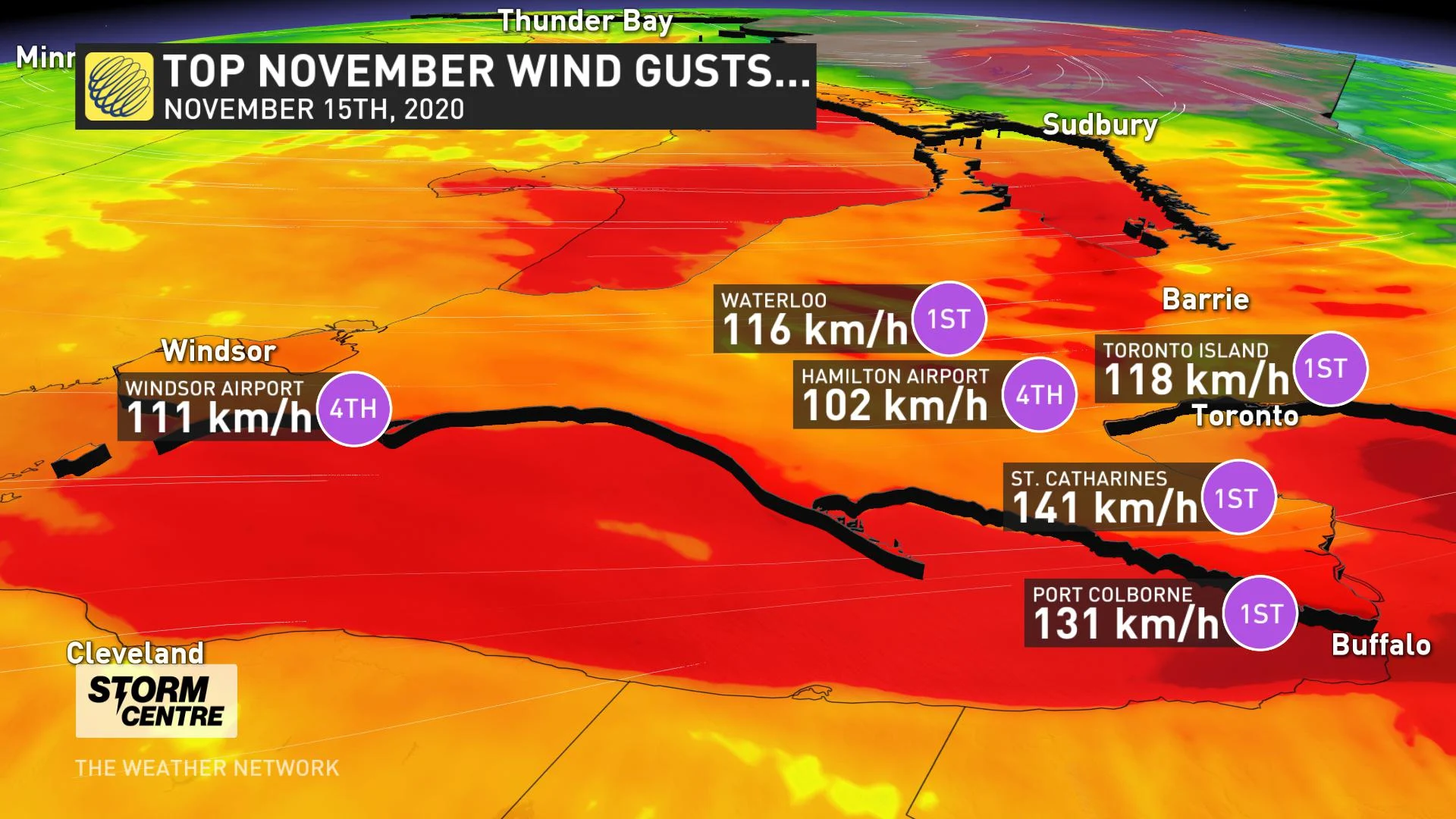
Monday, November 16th 2020, 9:45 am - Widespread damaging winds swept through Ontario Sunday, with hurricane force gusts strong enough to cause ground shaking in Toronto.
Heavy rain, fierce winds and severe thunderstorms whipped through much of southern Ontario Sunday, courtesy of a potent Colorado low with widespread impact felt right across the province.
Record-breaking winds were reported throughout the day, including a gust of 118 km/h at Toronto Island and an impressive 141 km/h gust in St. Catharines. Those were both strong enough to set new all-time records for the month of November.
Seismologist John Cassidy flagged an unusual signal on the sensitive seismographs placed along the Leslie Street Spit in Toronto.
"The wind speed was strong enough to be tracked on the data plot from the output of the seismometer Sunday evening," explains Weather Network meteorologist Tyler Hamilton.
Ground shaking in downtown Toronto from the ongoing #ONStorm.
— John Cassidy (@earthquakeguy) November 15, 2020
Seismic data from the CNSN TORO, data plot from @IRIS_EPO
Stay safe #Toronto.
Wind gusts to nearly 120 km/h@50ShadesofVan @RyanVoutilainen pic.twitter.com/sLfqveJX4b
__WHAT'S NEXT? Arctic air, bands of lake-effect snow follow damaging wind storm __
The blustery conditions also created flooding along shorelines and a flood warning was issued for Lake Erie by the Long Point Region Conservation Authority (LPRCA). The Port Stanley Buoy in Lake Erie recorded waves of 4.7 metres (15.4 feet).
At the height of the storm Sunday evening, over 230,000 Hydro One customers were without power due to trees being blown over and tearing down power lines. According to officials, crews are working as quickly and as safely as possible to restore power to all customers.
Some of the storm damage is also indicative of a possible tornado, as survey teams from the Northern Tornadoes Project are called to assess the damage track and destruction.
Here’s a closer look at the impacts from the potent storm that slammed southern Ontario:

Well, that’s not something you see everyday. Waves creating through the park here in Fort Erie. @weathernetwork #ONStorm pic.twitter.com/5EVGYrJ9Hx
— Mark Robinson (@StormhunterTWN) November 16, 2020
Whole tree uprooted on Lakeshore Rd. just west of Burnaby. Took out the fence @seanlovesmamma @Crossfit_ftb @ONwxchaser #ONstorm pic.twitter.com/M0qQyhTwkW
— Isabel (@isabel_ONwx) November 15, 2020
Property owners are starting to get the generators and pumps out. Flooding is ongoing on and over the dike.#ltvca #ckont #onstorm #onflood pic.twitter.com/tm0baxVY8V
— Jason Homewood (@Jason_Homewood) November 15, 2020
#CP24 #ONStorm this is crazy!! This (was) the fence between my neighbors and I!! 😱 pic.twitter.com/2c2irBe5Ce
— Hakamata Tsunagu🌙 (@Haka_mata) November 15, 2020
Credit: Karen Zimmerman, St. Thomas, ON
#ONStorm @CBCToronto @CityNews @CTVToronto This is seriously dangerous!! Boards flying everywhere, landing on the street and crashing into houses. Be careful near Yonge and Wellesley! pic.twitter.com/5z2wjYoUA7
— Zoe (@FlozoBozo) November 15, 2020
Seiche has completely taking over Port Dover. Water has completely covered walker street up to Main Street! #ONStorm #onwind #onflood @weathernetwork @ONwxchaser @StormhunterTWN pic.twitter.com/KyNTeXMfbR
— Billy Pickles (@BillyPickles6) November 16, 2020
Wind and waves are really starting to pick up now on Point Pelee Drive just south of Sturgeon Creek. Can’t imagine being at the East end of #LakeErie @LakeErieNorth #onwx #onstorm @weathernetwork pic.twitter.com/i1wpokSmdm
— Bob Wickett (@BobWickett) November 15, 2020
As the winds and waves continue to build, this is what it's currently like on Erie Shore Drive in #ckont. It will continue to get worse.#ltvca #onstorm #onflood pic.twitter.com/Xriun0ohdx
— Jason Homewood (@Jason_Homewood) November 15, 2020
Waves are cresting over the breakwall in the Erieau navigation channel and getting inside buildings. Also, cresting over the top of my rubber boots. #soaker #ltvca #ckont #onstorm #onflood pic.twitter.com/UfRVFhrRuw
— Jason Homewood (@Jason_Homewood) November 15, 2020
Colchester beach #ONStorm pic.twitter.com/jVY8wk1Dpy
— mandms333 (@mandms333) November 15, 2020
Regional road 65 going south with two trees down over the road. squall line blasting through knocked them over #onstorm pic.twitter.com/3uVjraaqC3
— Anton Falco (@AntonFalcoWx) November 15, 2020