
Significant snow threat expands across parts of western Canada, risk of 30 CM

Expect a false start to winter with a blast of November-like weather late this week and weekend (and continuing into next week) that will cause significant impacts and or hardships with the fall harvest across parts of western Canada. Here's what you need to know.
Wednesday marks the final day of pleasant, early fall weather for parts of the western Prairies -- at least, the last one for a while. Even though fall has just begun, winter will come to call by the end of this week, with a full-blown fall snowstorm on the horizon. We take a look at the abrupt change, and who should have their shovels at the ready, below.
Visit our Complete Guide to Fall 2019 for an in-depth look at the Fall Forecast, tips to plan for it and a sneak peek at the winter ahead
WEATHER HIGHLIGHTS:
Mainly sunny with mild temperatures Wednesday
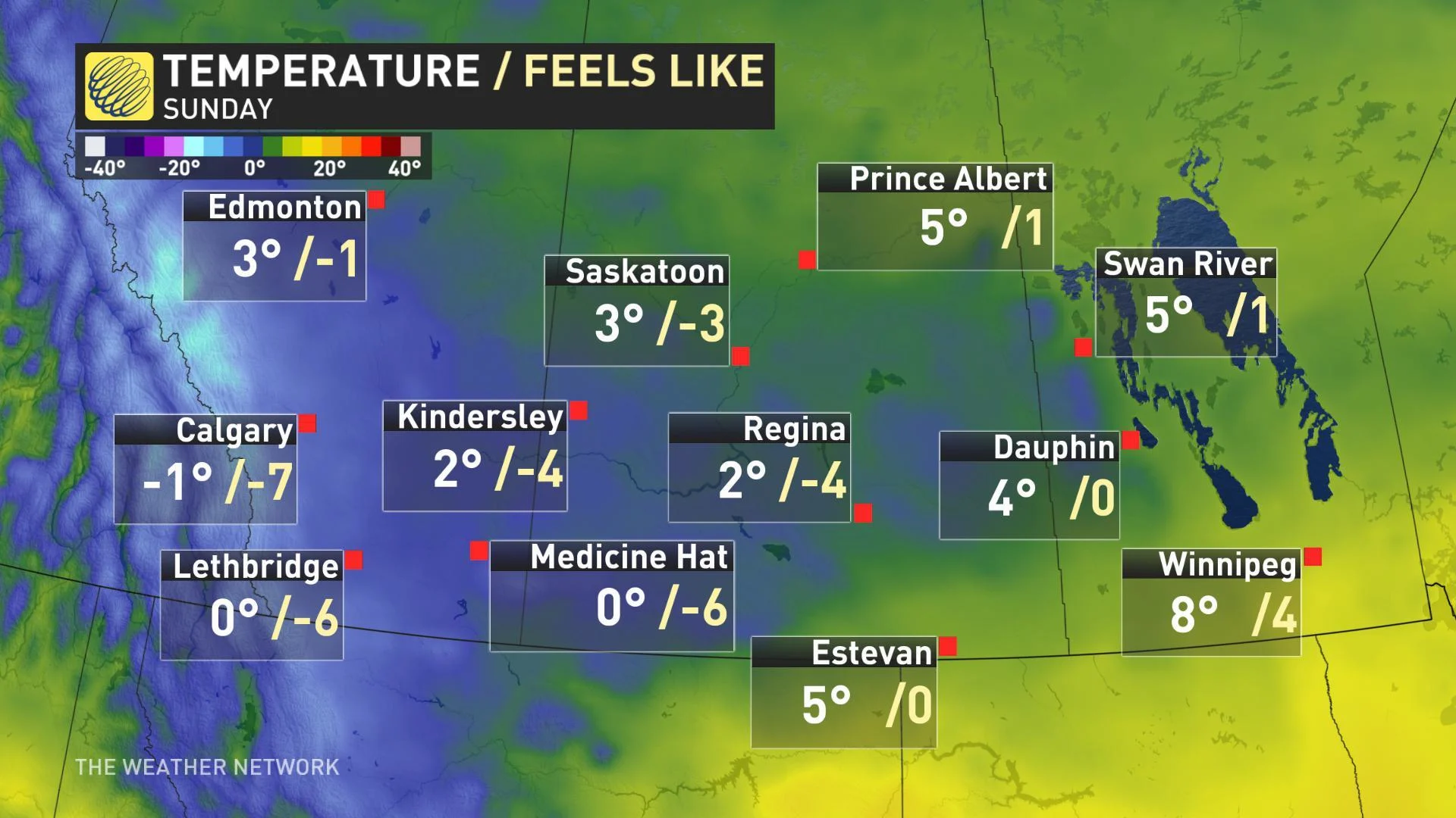
Downturn in temperatures begins Thursday; sharp drop into the weekend
Several chances for snow late week and into the weekend for Rockies, southern Alberta, southern Saskatchewan
Stay on top of ALERTS in your area
WATCH BELOW: SHOT OF COLD AIR TAKES AIM ON PRAIRIES
While the first few days of the new season have been sunny and mild in Alberta, a sharp change is set to roll in for the second half of the week.
An upper-level low pressure system over the northern Prairies has been strengthening as it moved toward Hudson Bay for the past few days. Now that it's arrived over northern Manitoba, a block in the jet stream has left it with nowhere to go.
That brief block will leave the upper low spinning in place into the weekend, and -- most importantly for those in the Prairies -- pumping cold air down from the Arctic into next week.
All that spells conditions primed for a 20-degree temperature drop between the start of the work-week and the end, and the risk for first-week-of-autumn snow -- even at low elevation.
The heaviest of the snowfall is, as you'd probably guess for this time of year, expected to be into the mountains, with some hefty accumulations possible along the Rockies through Friday. Several centimetres of snow on the ground isn't out of the question for the foothills, however.
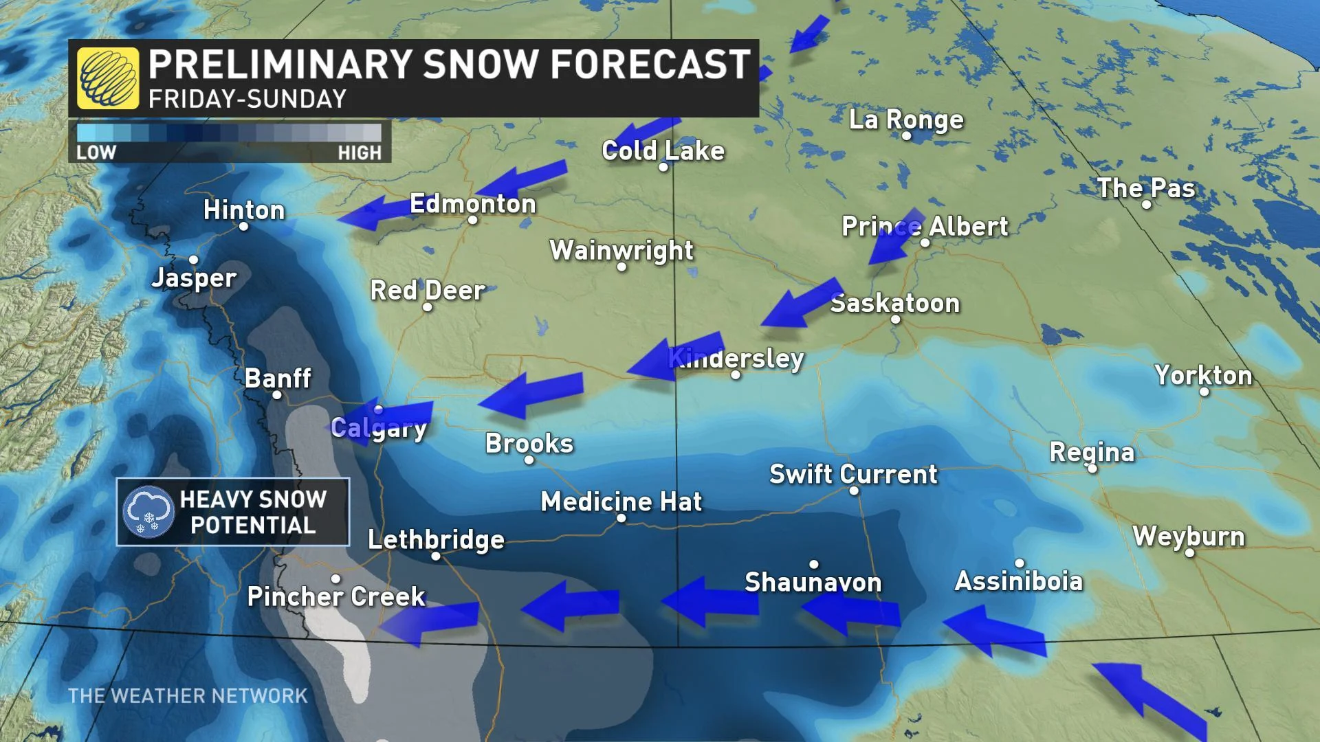
FALL SNOWSTORM THIS WEEKEND
Long range guidance is hinting at a Colorado low for the weekend that may generate even more snow across southern Alberta, extending into southern Saskatchewan and Manitoba by early next week.
A very heavy swath of snow is likely, continuing through Saturday and Sunday with some forecast models suggesting up to 30 cm of snow in some of the hardest-hit areas by Monday.
"Currently, the Pincher Creek area has the highest threat to reach, or even exceed, 30 cm of snow by the end of the weekend," says Weather Network meteorologist Dr. Doug Gillham. "But widespread totals of 10 to 20 cm are also expected across parts of southern Alberta and into southern Saskatchewan."
There is still some uncertainty regarding the exact track of this potential potent system, and it will be one worth watching as we head toward the weekend.
"This chilly pattern and snow come with significant hardships for the fall harvest," says Gillham. "It's also concerning that the leaves are still on the trees in areas that could see substantial accumulations of wet snow giving a risk for tree damage and power outages."
Stay with us here at The Weather Network for all your latest forecast updates.


