
Fierce winds slam Newfoundland, potent East Coast snowstorm looms

Atlantic Canada is in the middle of a stormy pattern this week, with one low pushing across the region through Tuesday, bringing potentially damaging winds exceeding 100 km/h in Newfoundland. Meanwhile, another system is already following closely behind, potentially becoming a significant snowstorm for the East Coast into late week. If so, it could bring the first major snowfall of the season for Nova Scotia. However, there remains some uncertainty with regards to the track of the low at this time, with different scenarios on the table for impacts, timing and where the heaviest snow will fall. More on the potentially damaging winds in Newfoundland Tuesday, and an early look at the winter storm that threatens significant snowfall Wednesday, below.
Visit our Complete Guide to Winter 2022 for an in-depth look at the Winter Forecast, tips to plan for it, and much more!
TUESDAY: RAIN WINDS DOWN IN MARITIMES, WINDS INTENSIFY IN NEWFOUNDLAND
The messy low-pressure system that kick-started the work week with a wintry mix has transitioned into an all-rain story for Atlantic Canada. Through Tuesday, conditions will gradually improve for the Maritimes as the rain begins to subside.
Some areas of western Newfoundland could see accumulative totals of 30-50+ mm of rain by the time it winds down, with an additional 10-20 mm left to fall in Nova Scotia and New Brunswick.
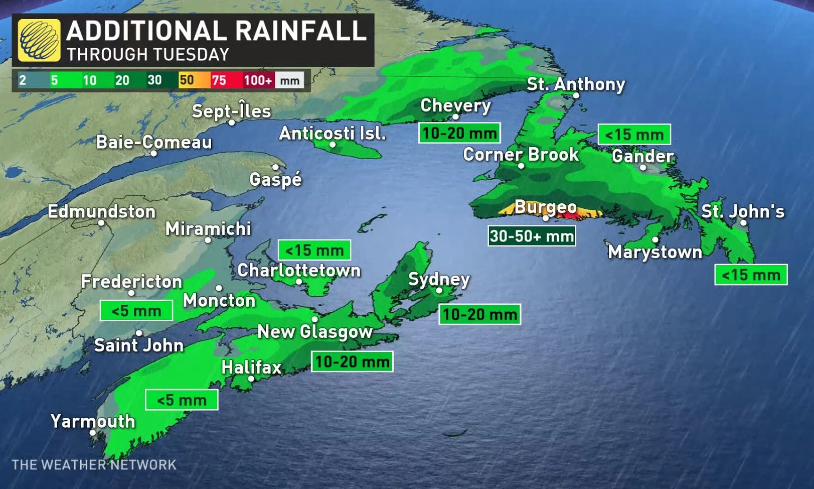
As well, winds will be breezy, reaching the 50-80 km/h range in the Maritimes.
The cold front will then make its way through Newfoundland Tuesday, bringing potentially damaging winds across the island and heavy precipitation, especially along the southern coastal sections. Wind warnings are in place, with Environment and Climate Change Canada (ECCC) cautioning of possible damage to buildings, such as to roof shingles and windows, as a result.
Southwesterly wind gusts up to 110 km/h are possible, especially along the coast. Local enhancement in south to southeasterly flow typically occurs in the vicinities of Cape St. George, Port au Port Bay, the outer Bay of Islands, Trout River Bay, Bonne Bay, Western Brook Pond and St. Pauls Bay.
There will also be sea-effect snow squalls developing in Newfoundland Tuesday, potentially lingering into Wednesday.
WEDNESDAY/THURSDAY: CLOSELY WATCHING A POTENT SNOWSTORM
Beyond, a deepening low-pressure system will rapidly intensify as it tracks south of Atlantic Canada Wednesday night and Thursday. There is still some uncertainty in the exact storm track and snow totals.
At this point, it looks like western and southern Nova Scotia could be in line for 15-20+ cm of snow, including Halifax and Sydney, starting Wednesday evening. Special weather statements are already in effect.
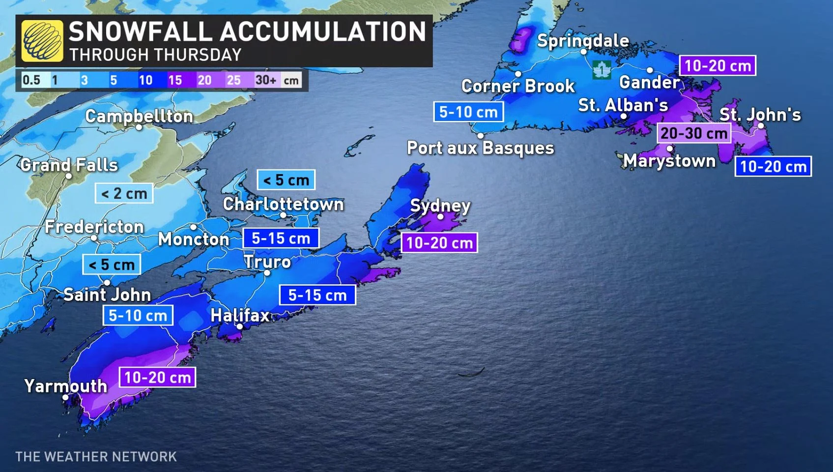
Between 5-10 cm of snow is expected near the Bay of Fundy and eastern PEI.
"This will be a tricky forecast for St. John's Newfoundland," says Dr. Doug Gillham, a meteorologist at The Weather Network. "The exact storm track will be the key to getting 25-40 cm of snow versus much lower totals with a transition to ice and possibly rain."
Heavy snow between St. John’s and Gander is expected, with between 20-40 cm likely and the risk for blizzard conditions.
"Strong winds will accompany this storm, with gusts of 70-100 km/h expected for St. John’s as the storm heads out to sea," Gillham adds.
Looking ahead further, another system will bring milder temperatures and rain to the region on the weekend. Conditions will turn colder early next week.
Be sure to check back for updates on the forecast in Atlantic Canada.


