Hurricane warnings in Maritimes as ‘historic’ Hurricane Fiona nears

Fiona expected to impact Atlantic Canada and eastern Quebec with heavy rainfall and powerful hurricane force winds starting late Friday. 'This is going to be a storm for the ages,' chief meteorologist warns.
Residents of Atlantic Canada now have less than 24 hours to prepare for the onset of high winds and heavy rain associated with major Hurricane Fiona as it closes in on the region.
The storm remained a powerful Category 4 hurricane on Thursday evening as it accelerated toward Bermuda, where a hurricane warning is in effect through Friday morning.
Forecasters expect the outer edges of Fiona to arrive in Nova Scotia and Prince Edward Island by Friday evening, with conditions deteriorating rapidly as the powerful storm approaches the region.
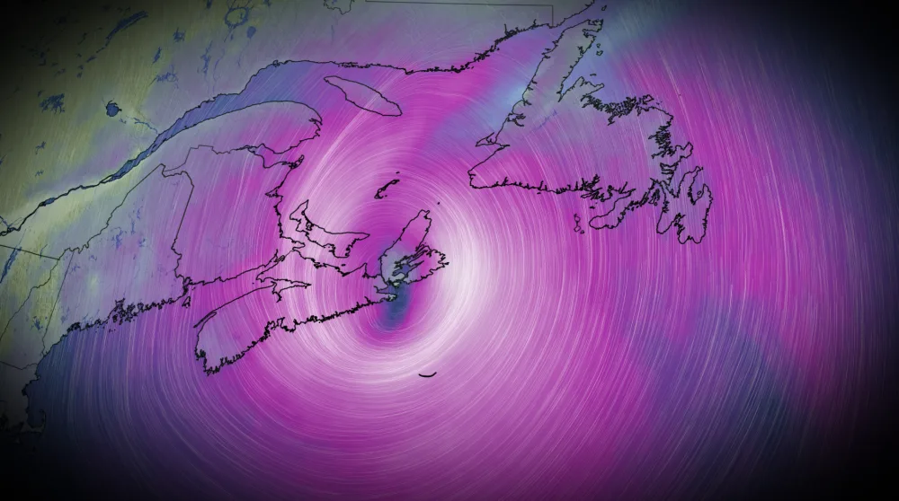
Fiona will hit the two Maritime provinces with all its might Friday into Saturday morning, eventually moving into the Gulf of St. Lawrence through the day on Saturday as it weakens.
Hurricane safety: What to do before, during, and after landfall
"This is going to be an historic storm, we know it's going to be massive," says Chris Scott, Chief Meteorologist at The Weather Network. "We want to get across the point here that this is not just a hurricane, it's more like a hurricane and a nor'easter combined."
According to Scott, it's like comparing the intensity of Hurricane Juan, which was the most devastating storm to hit the Maritime provinces, combined with the size of Hurricane Dorian, a massive storm that set a record for the most people without power at one time.
WATCH: Forecasters fear Hurricane Fiona could be worse than Dorian's destructive path across the East Coast
The U.S. National Hurricane Center (NHC) found that Hurricane Fiona changed little through the day on Thursday, maintaining its ferocious maximum sustained winds of 215 km/h.
Fiona’s maximum winds will start to tick down as it approaches the Maritimes, but it will remain a large and powerful storm when it hits Friday and Saturday. Forecasters expect Fiona to continue producing widespread hurricane-force winds and wind gusts into Saturday, even after the system has lost its tropical characteristics.
RELATED: How hot water fuels the world’s most powerful hurricanes
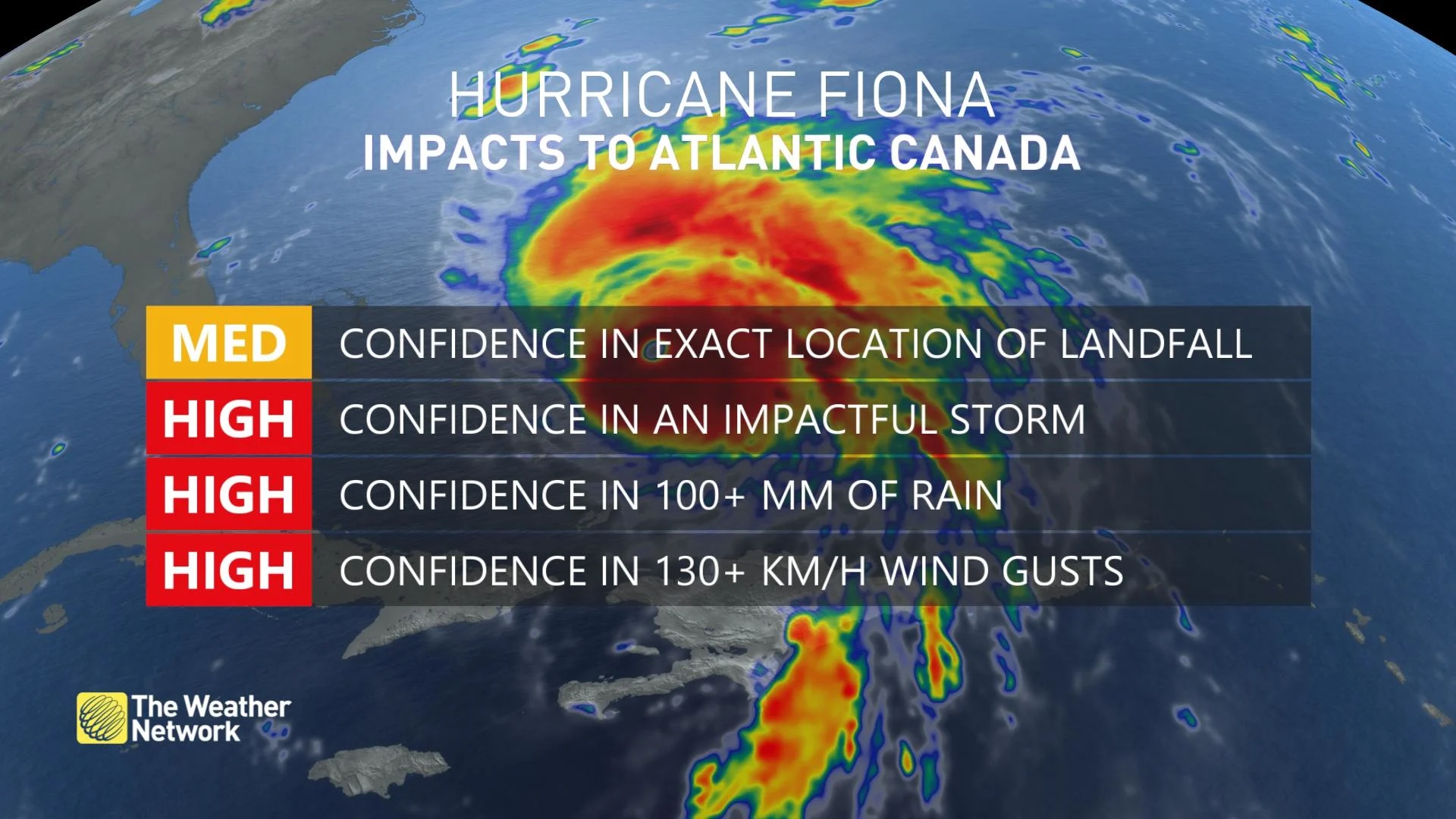
There is little doubt that Fiona will have a major impact on the region. Residents should plan and prepare for the storm and its significant impacts now, before conditions start going downhill on Friday and Saturday. Fiona is expected to impact Atlantic Canada and eastern Quebec with heavy rainfall and powerful hurricane force winds.
Environment and Climate Change Canada (ECCC) issued a tropical cyclone information statement from the Canadian Hurricane Centre (CHC) and it covers the entire region. Hurricane and tropical storm warnings have also been issued, replacing the previous watches.
"This storm is shaping up to be a potentially severe event for Atlantic Canada and eastern Quebec. Numerous weather models are quite consistent in their prediction of what we call a deep hybrid low pressure system, possessing both tropical and intense winter storm properties with very heavy rainfall and severe winds," the CHC said in the updated tropical cyclone statement Thursday morning.
MUST LISTEN: Meteorologists carefully track the timing and impacts of Fiona. What you need to know:
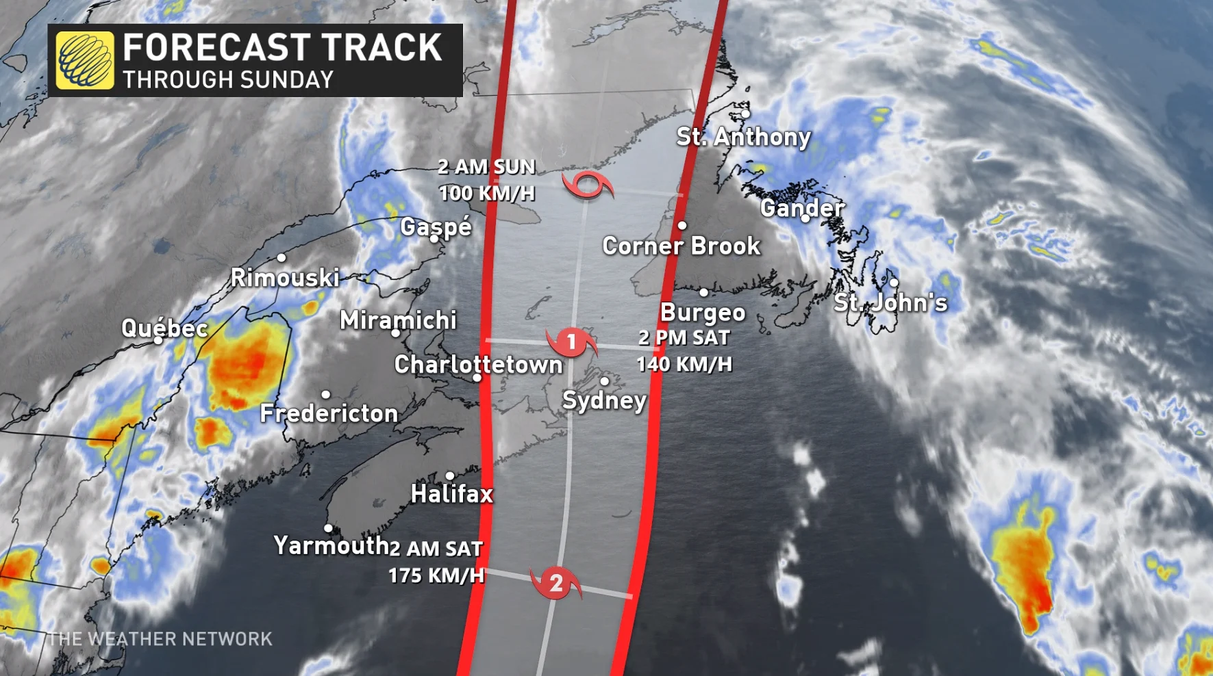
Hurricane Fiona will continue on a northeasterly track that takes it close to Bermuda overnight Thursday into Friday morning. From there, an upper-level trough will grab the storm and pull it northwest toward Atlantic Canada.
This trough will help the storm transform into a large and potent post-tropical cyclone by late Saturday. Landfall is expected across eastern Nova Scotia by Saturday morning.
Warm water temperatures in the western Atlantic are contributing to the storm’s strength. These waters are much warmer than normal, allowing the storm to maintain tropical characteristics and delaying its transition to extratropical cyclone status.
DON'T MISS: Essential items for your emergency "grab-and-go" kit
Fiona's incoming impacts include:
Large waves
Swells
Storm surge
Damaging winds
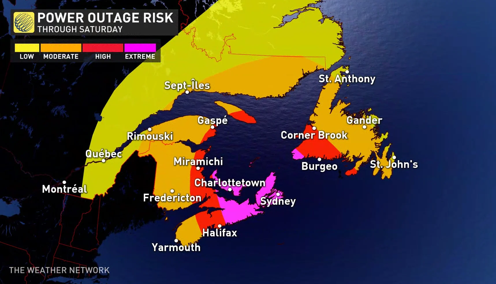
Widespread power outages
Heavy rain
Flooding
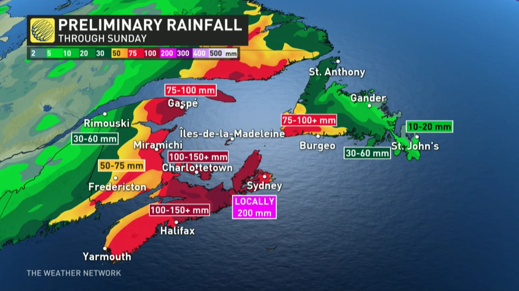
Rain: A widespread swath of 100-200 mm of rain is likely across parts of Atlantic Canada with Fiona, especially north and west of the track, where heavy rain could lead to flooding. The highest rainfall amounts are likely for eastern Nova Scotia, southwestern Newfoundland and the Gulf of St. Lawrence region. Road washouts and erosion are also possible.
Wind: High winds will cause major issues across the region. Gusts of 100+ km/h are expected as Fiona slams into the Atlantic provinces.
The system’s transition from a tropical cyclone to a post-tropical cyclone will expand its wind field, exposing a much larger area to strong winds.
Winds are strongest in the eye of the storm when it is a tropical system. As it starts to transition into a post-tropical storm, those strong winds start to expand throughout most of the system.
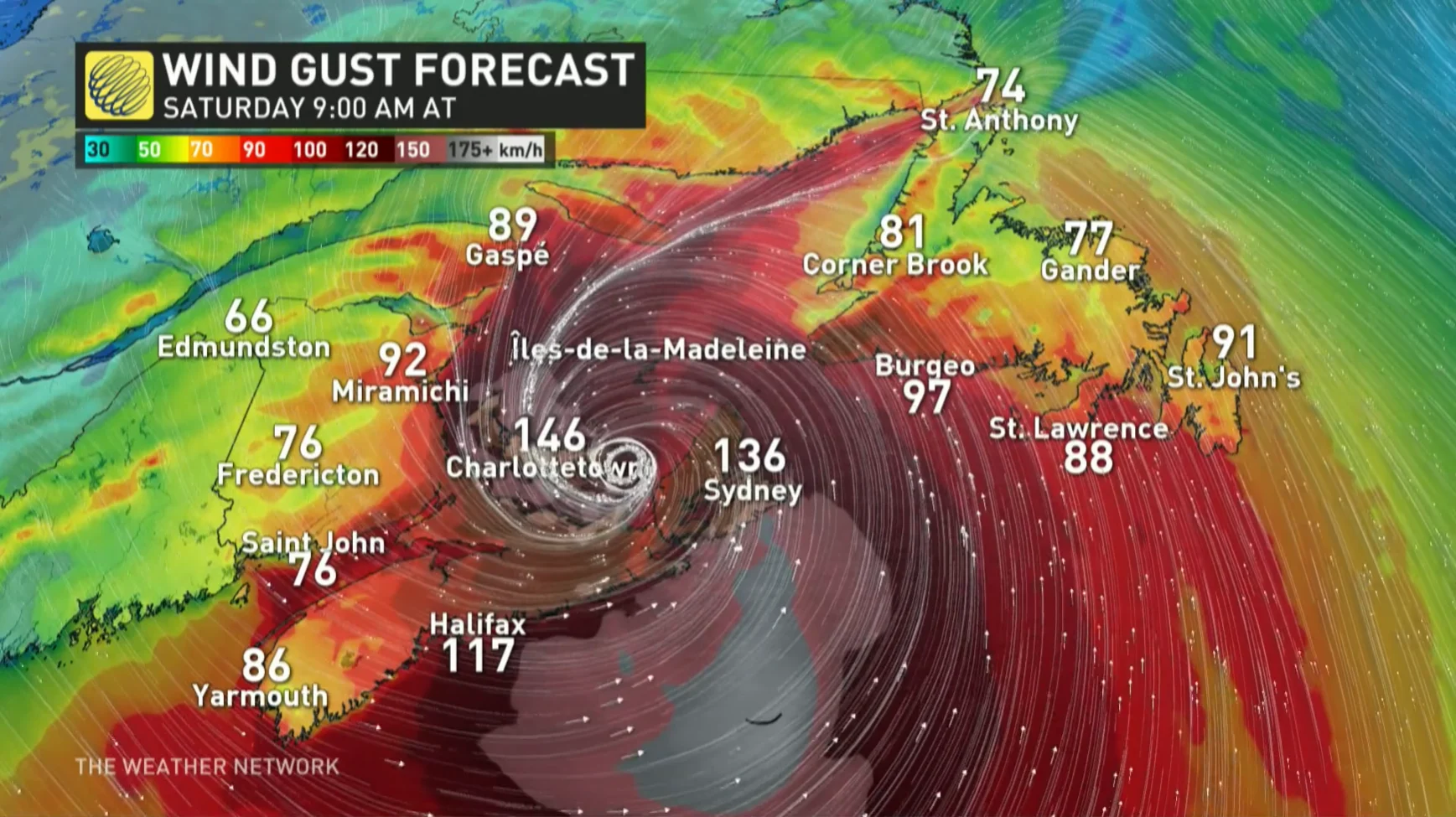
Even stronger gusts upwards of 150 km/h are possible for eastern Nova Scotia and P.E.I. With trees still in full leaf, there will also be a widespread risk of power outages across the region.
"All of P.E.I. will see a prolonged period of very strong winds from the north and these gusts will likely gust in excess of 150 to 160 km/h," Scott warns. "That will cause widespread power outages and frankly, I'm afraid for what this is going to do to the island...prepare to be without power for some time."
These types of winds can lead to significant structural damage to buildings as well.
According to Scott, for P.E.I., "this is going to be a storm for the ages."
Surge and waves: There will also be some rough and pounding surf, especially for parts of Nova Scotia and Newfoundland. Large waves are expected to reach the eastern shore of Nova Scotia from the south on Friday, building to more than 10 metres before reaching southern Newfoundland Saturday morning.
"Some of the waves over eastern portions of the Gulf of St. Lawrence could be higher than 12 metres, and the western Gulf will see waves from the north up to 8 metres in places, which will cause significant erosion for north facing beaches," the CHC says. "Iles-de-la-Madeleine will also see some coastal erosion from waves."
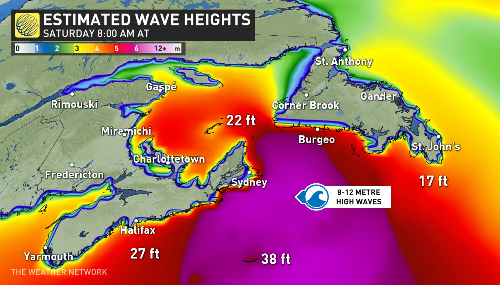
The highest risk for coastal flooding will be a combination of storm surge with large waves moving onshore. For most areas, the highest water levels are expected near high tide some time on Saturday morning.
WATCH: Canadians rush for supplies as Hurricane Fiona takes aim
Residents across the region are being urged to be prepared. Making sure an emergency kit is ready, clearing downspouts and storm drains and having generators in working order, are all important factors to take into account.
Nova Scotia Power announced on Wednesday that the company will activate its Emergency Operations Centre at 8:00 a.m. on Friday.
"Based on the recent weather forecasts, we are opening our Emergency Operations Centre Friday at 8 am to ensure proper plans and crews are in place to manage our storm response," the company said in its press release.
P.E.I.'s Emergency Measures Organization (EMO) is activating to Level 1 enhanced monitoring and is encouraging Islanders to replenish supplies for up to five days, including food, water, heat and fuel supplies.
In Newfoundland's west coast city of Corner Brook, Mayor Jim Parsons said sandbags are already being filled, catch basins are being cleared and trees are being trimmed in anticipation of the hurricane-force winds.
Stay tuned to The Weather Network for the latest forecast details on Fiona's track and possible impacts on Atlantic Canada.