Ontario: Damaging wind threat Wednesday, eyes on wintry weekend mess

A strong Colorado low brings rain, snow, and very strong winds to Ontario through mid-week.
The next in a series of storms is on Ontario's doorstep -- a Colorado low bringing rain, snow, and some potentially damaging winds for Wednesday. Up to 30 cm of fresh snow is on the way for some areas, while winds gust to near 100 km/h for others. And while that system will be sweeping out of the region for Thursday, another winter-like storm looms for the weekend. More on the timing and impact of this Colorado low, plus a look at the weekend system that threatens slick conditions for the start of December, below.
Visit our Complete Guide to Winter 2019/2020 for an in-depth look at the Winter Forecast, tips to plan for it and a sneak peek at the spring season next year
WEATHER HIGHLIGHTS:
Colorado low moves into region for Wednesday
Rain, snow, and wintry mix all expected across province; mainly snow in north and rain in south
Very strong winds expected for southern Ontario, particularly along lakes, Wednesday
Cold pattern locks in for early December
Stay up-to-date on the ALERTS in your area
EYES ON A CLASSIC FALL STORM
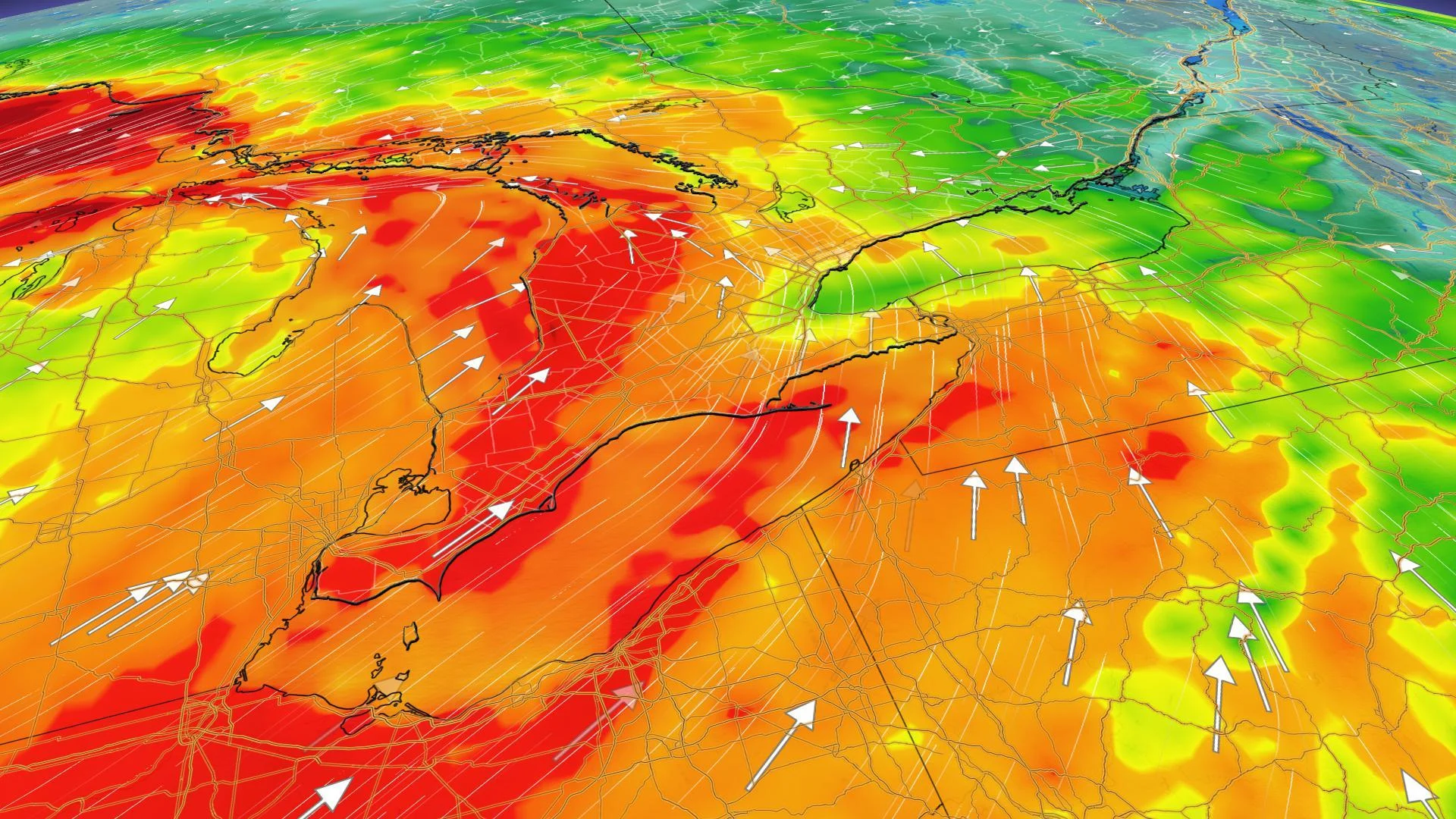
A Colorado low brewing over the central United States moves into Ontario for Wednesday, bringing a mix of precipitation types and some powerful winds to the region.
The leading edge of the system will begin creeping into southwestern Ontario through the pre-dawn hours, with a messy mid-week in store for much of the province.
HEAVY SNOW PROMPTS WINTER STORM, SNOWFALL WARNINGS IN THE NORTH
Heavy snow will develop north of the low's track, bringing as much as 30 cm for some north of Lake Huron and across the Nickel Belt. Significant impacts to travel along the Trans Canada Highway are likely, with not only heavy snow and strong winds but the potential for some freezing rain or ice pellets through Wednesday.
Environment Canada has issued a winter storm warning with heavy and local blowing snow expected through Wednesday evening.

"This system will intensify as it tracks into the Great Lakes region on Wednesday, bringing potentially damaging winds with gusts between 60-80+ km/h expected," says Weather Network meteorologist Dr. Doug Gillham. Closest to the shores of lakes Erie and Ontario, gusts of 90 to 100 km/h are likely Wednesday afternoon, prompting wind warnings for parts of the Niagara region and Prince Edward county.

These strong southwest winds are likely to drive coastal flooding for some shoreline areas, especially at the eastern end of Lake Erie.
THE SCIENCE BEHIND A SEICHE: HOW THIS CAN CAUSE MAJOR GREAT LAKES FLOODING
Precipitation across the south is expected to stay as rain on Wednesday, but Arctic air wrapping around behind the low pressure centre will mean a big temperature drop across much of the south between Wednesday and Thursday. While highs are set to climb into the low teens for the southwest, and potentially the GTA, on Wednesday, Thursday afternoon will be back down near freezing across the board.
That, combined with continuing winds from the northwest will bring the potential for some wrap-around and lake-effect snow through Thursday.

EYES ON MESSY WINTER SYSTEM FOR THE WEEKEND
While the exact timing and impacts are still uncertain, a winter-like storm is expected to track into southern Ontario, thanks to an unusually powerful bomb cyclone that crashed into the west coast this week.
"During Saturday night and early Sunday, freezing rain, ice pellets and snow will develop across our region and continue into Sunday," says Gillham.
Currently, the greatest snow and ice accumulations are expected north of Lake Ontario, with lesser amounts for southern parts of the GTA due to mixing with freezing rain and rain. The snow is also expected to extend northeast into Ottawa and Montreal on Sunday. Be sure to check back for updates as the forecast details of this storm will change over the week.