
Maritimes dig out after monumental snowfall, storm hits Newfoundland

A powerful winter storm will continue to impact Newfoundland into Tuesday morning after battering the Maritimes with blustery winds and 40+ cm of snow Monday.
A pwerful storm that brought considerable snowfall to the Maritimes into Monday, with 50 cm reported at Halifax airport, is bringing the same wintry impacts to Newfoundland. Heavy snow and intense winds are bringing blizzard conditions, which are expected to linger until early Tuesday morning. Drivers are urged to avoid travel as whiteout conditions will be present. Accumulative snowfall totals could hit upwards of 50 cm by the time the system departs, but some sea-effect snow will linger in western sections during the day, so expect poor road conditions to remain. While snow has moved out of the most of the Maritimes, sea-effect snow will also linger for Cape Breton until Tuesday afternoon. For what's left of the storm and ahead for the rest of the week, read below.
WEATHER HIGHLIGHTS:
30-40+ cm of snow reported across the Maritimes Monday
Strong wind gusts up to 80 km/h will linger, causing blowing snow and whiteout conditions
Additional 5-15 cm of snow for parts of Newfoundland through Tuesday morning widespread 15-30 cm for the Avalon
Strong winds persist in Newfoundland, blizzard conditions will lead to difficult travel
INTO TUESDAY MORNING: SNOW, BLIZZARD-LIKE CONDITIONS ACROSS NEWFOUNDLAND
Newfoundland is also expected to see some substantial snowfall totals through early Tuesday morning, with widespread snow and winter storm warnings still in effect. Many schools and businesses were closed first Monday as a result of the storm.
Some areas in western Newfoundland could see accumulative totals 50 cm of snow, while the rest of the island are in line to see 15-30 cm by Tuesday morning. Over the Avalon, precipitation has switched back to snow and will continue through the overnight.

Most of the heavy snow has fallen, but another 15 cm is expected in the overnight hours for Gander, 5-10 cm elsewhere across the island.
The winds are quite blustery with this system, with northeasterly gusts between 80-100 km/h anticipated to persist into Tuesday morning across Newfoundland.
Conditions will improve early Tuesday morning for areas along the south coast of the island as the snow tapers to flurries. However, strong northwesterly winds will persist into the afternoon, which may cause reduced visibility in blowing snow over some areas.

Strong winds and periods of snow will persist over more northern areas, including the St. John's metro area, into the day Tuesday before tapering to onshore flurries.
Arctic air pulling into the Atlantic region will bring sea-effect snow Tuesday morning for western Newfoundland.

THE MARITIMES HIT WITH 40+ CM OF SNOW, STORM PROMPTS CLOSURES AND CREATES TREACHEROUS TRAVEL
The powerful winter storm dumped 20-40+ cm of snow over parts of the Maritimes by Monday. Coupled with intense wind gusts of 80-100+ km/h, conditions across the region were treacherous during the day for anyone on the roads. The intense storm prompted the closures of businesses and government offices, as well as the cancellation of school classes. In addition, the strong winds knocked out power to thousands.
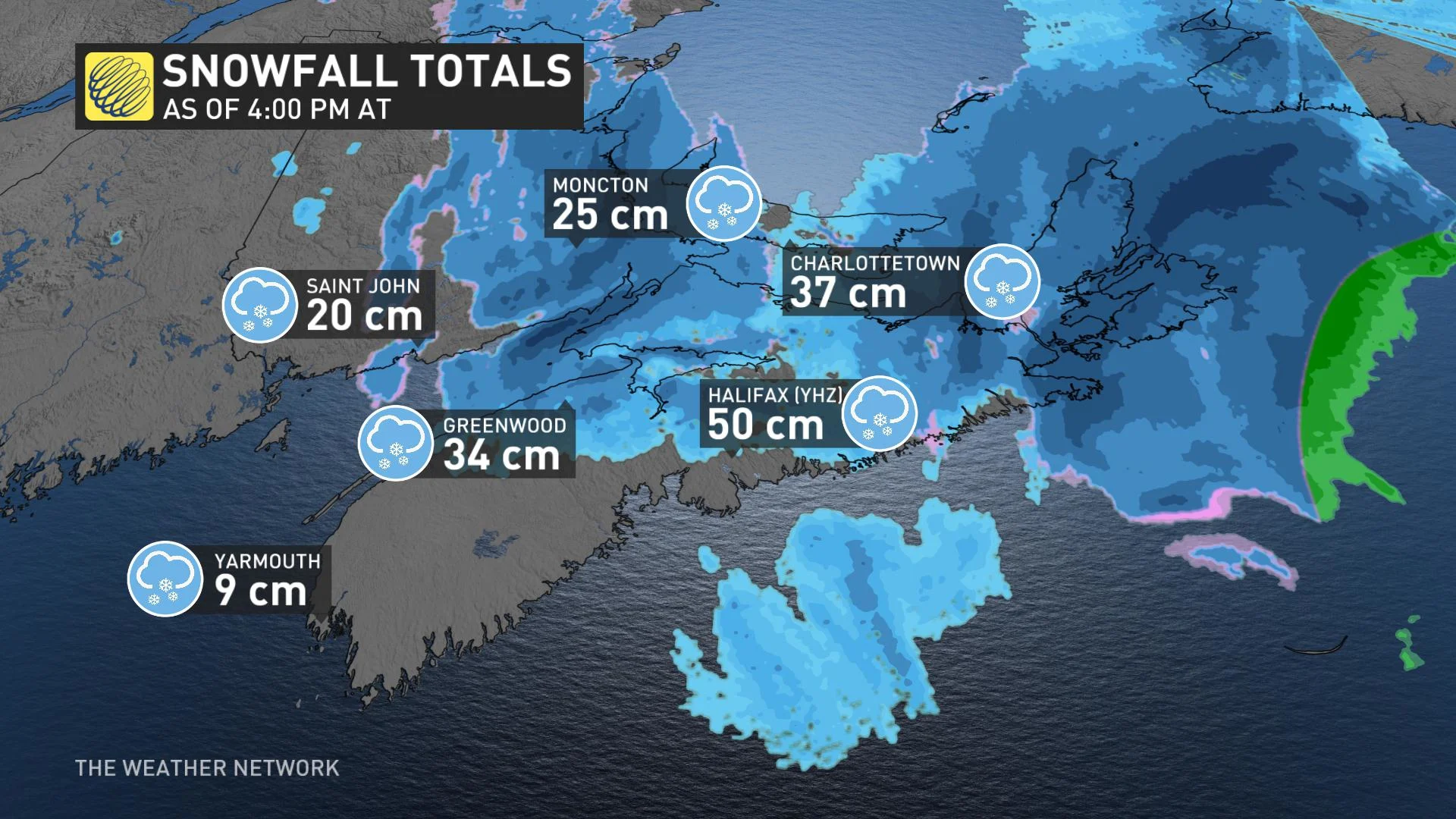
Some impressive snowfall totals have been recorded so far across the Maritimes, especially in Nova Scotia, where 50 cm has been recorded at the Halifax airport.
In other areas, 48 cm has fallen in Rawdon Gold Mines and Tidnish Bridge, 45-56 cm in Nappan, 45 cm in Amherst, and 42 cm in Middle and Kentville. Many more communities received 30+ cm of snowfall so far.
While the snow has departed the Maritimes, winds will remain gusty and could result in whiteout conditions in areas of blowing snow through the overnight period. A wind warning remains in place for Victoria County in Nova Scotia.
Conditions will be mostly fair across the region during the day Tuesday, but there will be some sea-effect snow lingering in Cape Breton until the afternoon when it diminishes.
COLDER TEMPERATURES SETTLE IN, ADDITIONAL SNOW WITH NEXT SYSTEM TUESDAY NIGHT
Colder, more seasonal temperatures will lock in across Atlantic Canada this week, with much of the snowpack from this latest storm sticking around for some time.
Forecasters are also watching the next system tracking south of the region on Tuesday night, likely clipping parts of southwestern Nova Scotia with some additional snow.

"Based on the current track, it looks like we will see 2-5+ cm of snow across southwestern Nova Scotia into Wednesday morning, and 1-3 cm possible for Halifax," says Weather Network meteorologist Dr. Doug Gillham.
Widespread heavy snow is also forecast for northern Newfoundland and Labrador for the remainder of this week, with an additional 20-40 cm forecast through Friday. Strong winds also threaten extensive blowing and drifting snow.
Forecasters are also watching the potential for a storm early next week, but too early to have confidence in the track and impacts.
Be sure to check back for the latest updates on this dangerous storm.
Thumbnail image credit: Jasmine Hoover, taken in Cape Breton.