Ontario: Snow squalls to taper off Thursday, but the bitter cold will continue

Snow to diminish Thursday morning, but the cold air will linger.
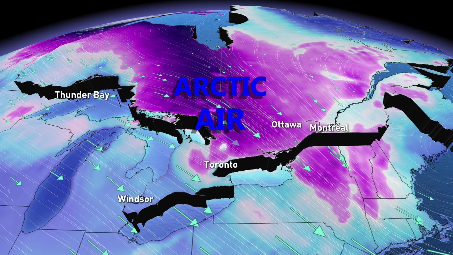
Southern Ontario residents were treated to a winter preview Wednesday, with continuous snow squalls throughout the day. The bands of squalls off Georgian Bay and Lake Huron created hazardous travel conditions, forcing the closure of several roads and causing several accidents. The worst of it is expected to end by Thursday morning, but the frigid air will remain for the rest of the work week. We take a look at how cold it will get Thursday, when it will end and a sneak peak at what to expect for Christmas, below.
WEATHER HIGHLIGHTS:
Widespread, heavy lake-effect snow created difficult travel conditions on major highways Wednesday. Check highway conditions.
Snow ends Thursday, but bitter cold continues through Friday
Milder air to return for Christmas
Stay up-to-date on the ALERTS in your area
THURSDAY -- CONDITIONS IMPROVE, BUT TEMPERATURES REMAIN FRIGID
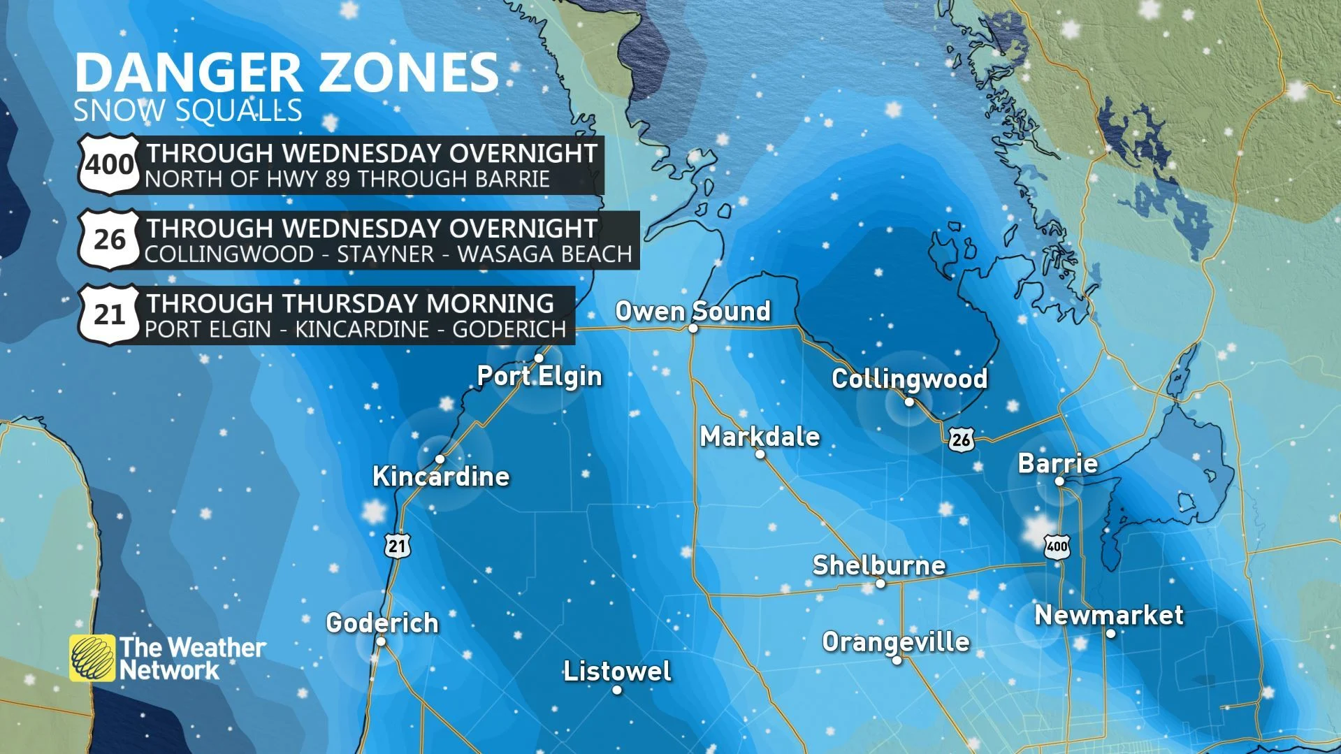
The persistent snow squalls that made for dangerous travel conditions Wednesday will finally ease off through Thursday morning, but not before a fresh dumping of the white stuff, which caused several accidents and prompted numerous road closures through the day.
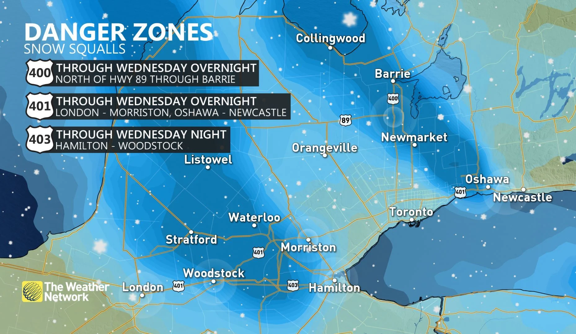
The two bands -- one off Georgian Bay and second off Lake Huron -- will continue through the overnight hours before diminishing Thursday morning. Some areas along Lake Huron and Georgian Bay could receive anywhere from 15-30+cm of snow through Thursday morning.
SEE ALSO: PHOTOS: Snow squalls create chaos on Ontario roads Wednesday
A system moving in from the west will help put an end to the lake-effect snow, but could produce some light flurries in central areas, as well as the GTA, Thursday afternoon. However, no significant accumulations are expected.
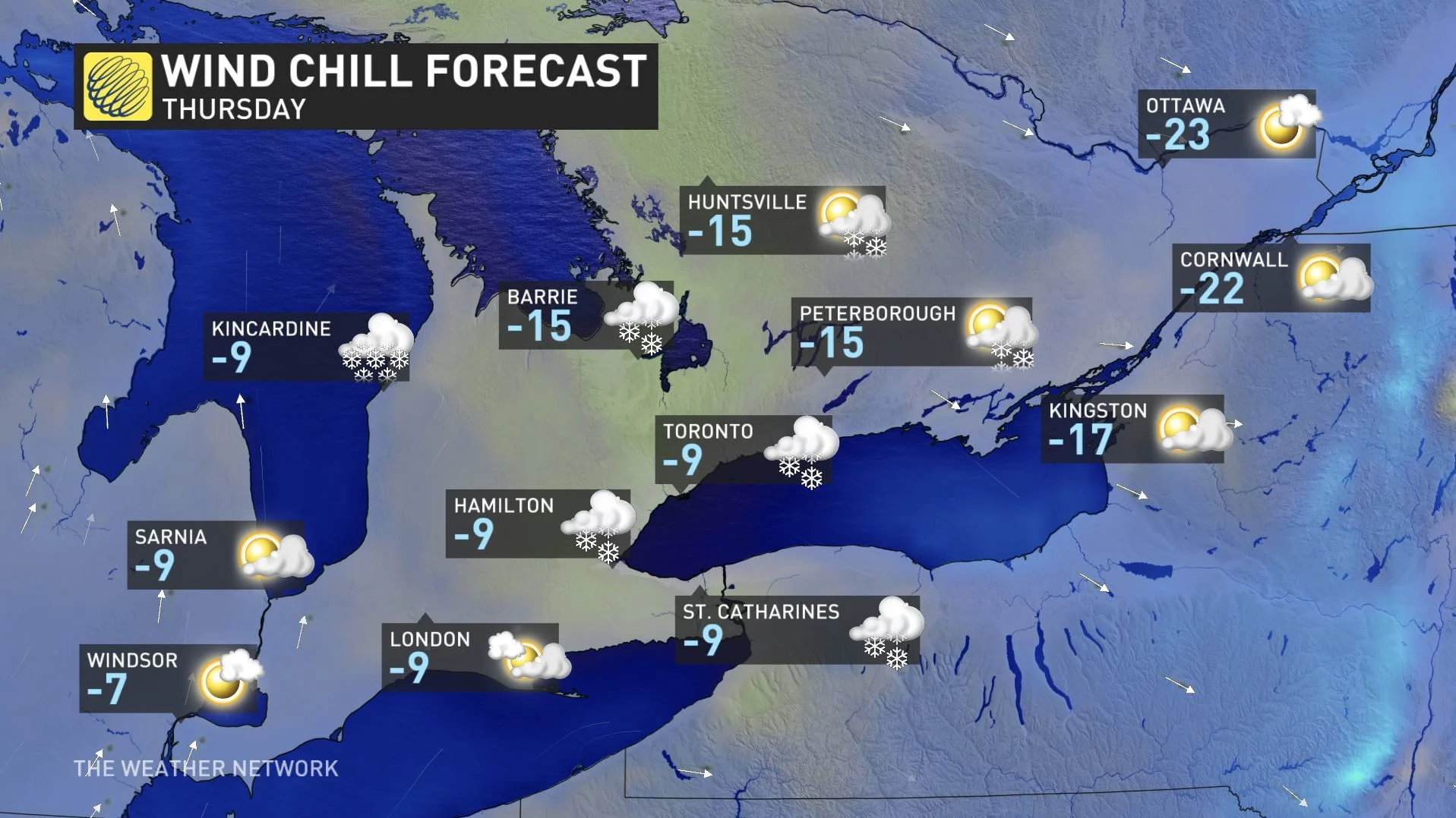
While the snow will end Thursday, temperatures will remain below seasonal and frigid -- with wind chills in central and eastern portions hitting the minus teens and low 20s.
The good news is the blast of cold air will ease off by the weekend, making way for warmer air to make its way into the region for next week.
WATCH BELOW: STORM HUNTER MARK ROBINSON DISCUSSES WEDNESDAY'S SNOW SQUALLS, WHAT TO EXPECT THURSDAY
WIND CHILLS PROMPT EXTREME COLD WEATHER ALERT IN TORONTO
Dangerous wind chills are possible into early Thursday, as bitter cold and light winds make it feel close to -23 around Toronto and close to or above -30 for parts of central and eastern Ontario.
The City of Toronto issued its second extreme cold weather alert of the season due to the temperature plunge, which will remain in effect until further notice. According to officials, these alerts are issued when the forecast suggests temperatures of -15°C or colder, or when the wind chill is forecast to reach -20 or colder. The alerts also activate local services that focus on getting and keeping vulnerable residents indoors.
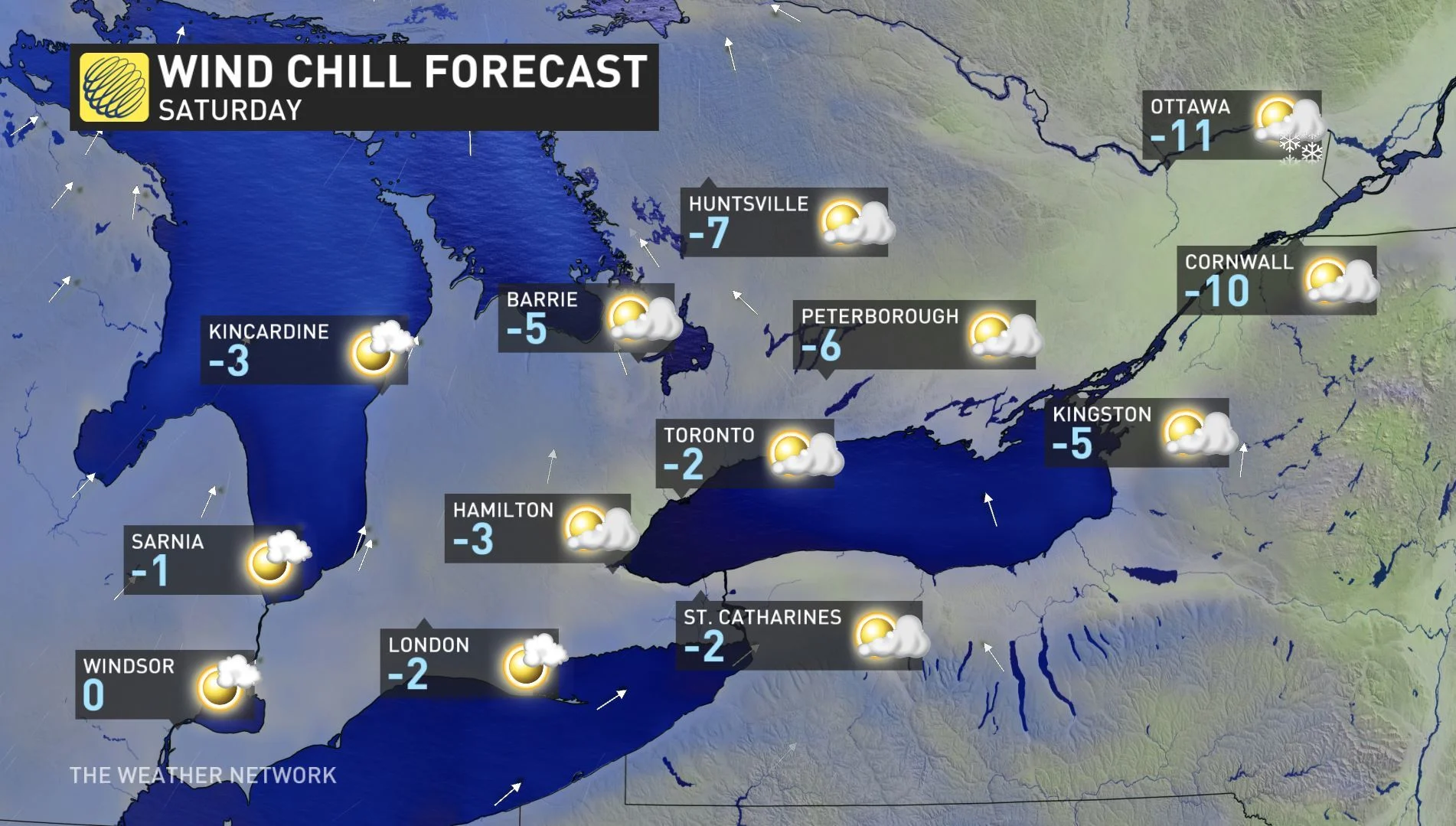
By Saturday, temperatures will improve and wind chills will ease off, making it more tolerable outside. Daytime highs will continue to climb throughout the weekend and into early next week.
Visit our Complete Guide to Winter 2019/2020 for an in depth look at the Winter Forecast, tips to plan for it and a sneak peek at the spring season next year
LOOKING AHEAD: MILDER AIR TO RETURN BEFORE CHRISTMAS
Although the frigid temperatures will continue Thursday, the worst of the chill will cease as we enter the last weekend before Christmas.
"Unusually quiet and mild pattern early next week and continuing through Christmas. Next system should hold off until after Boxing Day. Temperatures are expected trend closer to seasonal (but still on the mild side of seasonal) after Christmas," says Weather Network meteorologist Dr. Doug Gillham.
While the warmup might provide a welcome break for those already tired of the cold, Gillham also warns above seasonal temperatures early next week will put a white Christmas in jeopardy for southern Ontario, outside of the snow belt areas.
"The lake effect snow belts should be able to hold onto enough snow to stay white through Christmas, but areas with less than 10-15 cm of snow on the ground at the start of the weekend will be green by Christmas," Gillham adds.
These milder temperatures will provide ideal travel conditions however, with Christmas day looking to be mild and dry across the region.