
Major snowstorm closing in on southern Ontario, blizzard conditions expected

It's the calm before the storm across southern Ontario, with conditions set to take a dangerous turn for the worse through Friday evening.
"Heavy snow in combination with strong easterly winds will create significantly reduced visibility and hazardous travel conditions," says Environment and Climate Change Canada (ECCC) in a winter storm warning that lines most of the region. Snowfall warnings are also in place.
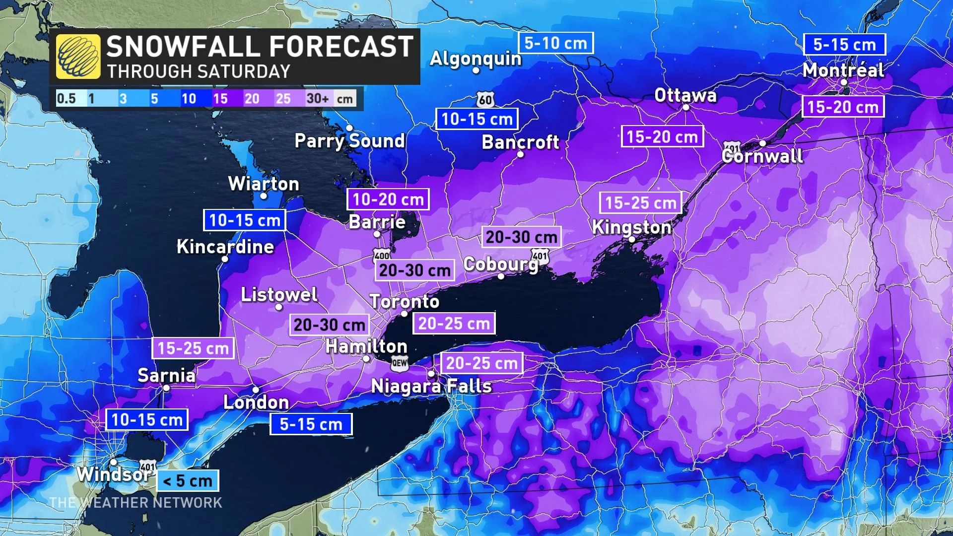
The system will produce 20-30 cm of heavy, wet snow across much of southern Ontario by Saturday, with gusty winds likely leading to dangerous blizzard conditions at times Friday night.
Visit our Complete Guide to Spring 2023 for an in-depth look at the Spring Forecast, tips to plan for it and much more!
The Texas low responsible for this latest snowy blast developed over the southern Plains on Thursday night, bringing wind, hail and reports of tornadoes to the southern United States.
This dynamic and moisture-laden storm will trek toward the Great Lakes on Friday, pushing heavy precipitation into southern Ontario during the evening hours. The storm will last into the first half of Saturday, possibly bringing the season’s biggest snowfall totals to some parts of the region.
WATCH: 10 million Ontarians will need the shovels this weekend
Dangerous blizzard conditions set in Friday night
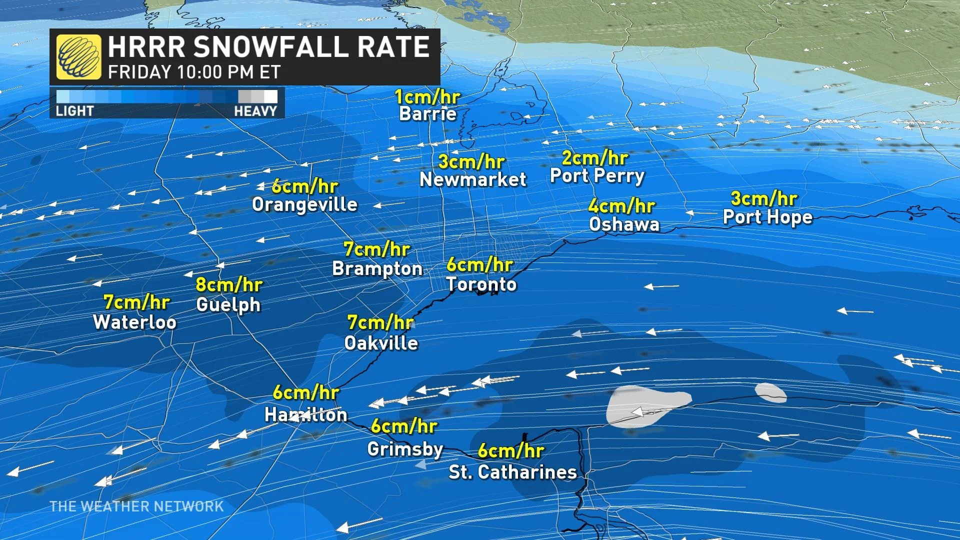
Your window to run errands and get where you want to be for the night is rapidly closing, with conditions set to take a serious turn for the worse by about 7 - 10 p.m. That's when snowfall rates between 5 to 8 cm per hour could create extremely hazardous travel conditions.
The combination of heavy snow and strong winds will lead to a period of blizzard conditions on Friday night, especially near the west end of Lake Ontario, including in the city of Toronto.
MUST SEE: Two major snowstorms roar across Canada as March arrives in style
The heaviest snowfall and gustiest winds will continue through the overnight hours and winds could easily gust to 60-70+ km/h during the storm.
"Prepare for quickly changing and deteriorating travel conditions," ECCC says. "Visibility will be suddenly reduced to near zero at times in heavy snow and blowing snow."
DON'T MISS: Be aware of your heart while shovelling heavy snow
The bulk of the precipitation we'll see from this system will fall as snow -- a change from the region's recent systems that have seen more of a messy mix with ice.
By the end of the storm on Saturday morning, we’ll likely see a blanket of 20-30 cm of snow across much of southern Ontario. The greatest uncertainty with this system is how much of the region in the southwest will change from rain to snow. There is also the chance for some areas from Sarnia to the Niagara Peninsula to see ice pellets mix in with the snow.
RELATED: How the City of Toronto is preparing for the big storm
MUST WATCH: As blizzard-like conditions target GTA roads, here's what to do
Making a bad situation worse, temperatures hovering near the freezing mark will make this a heavy, wet snowfall.
Gusty winds and the weight of this wet snow on trees and power lines could lead to an increased risk for power outages throughout the area. Remain mindful of trees and tree branches that could fall during the storm.
MUST SEE: Staying safe during a power outage
Shovelling up to 30 cm of snow is also a chore on its own, but the sheer weight of the snow will increase the challenge of the post-storm cleanup. Pay extra mind to the physical stress of shovelling heavy snow, taking care to stretch beforehand, shovel with safety in mind, and stop for frequent breaks.
Folks heading out to clean up on Saturday will encounter light snow lingering through the first half of Saturday as the system pushes east into New England.
Beyond this storm, temperatures will warm up a touch heading into the first weekend of March. Daytime highs approaching the mid-single digits will aid with cleanup efforts, though black ice will be a concern each night as lows drop below freezing.
WATCH: Do you know about the 4-4-4 rule regarding blizzards?
Prime ski conditions for March Break
Below-seasonal temperatures will return for the second half of next week and through the following week, which is March Break for most schools. At this point, we don't expect frigid weather, but not very spring-like either, with temperatures a few degrees colder than seasonal.
Southern Ontario ski areas should be in great shape for March Break.
Stay tuned to The Weather Network for the latest on this major storm eyeing southern Ontario.


