
Ontario: 'Coolest temperatures in months' follow Thursday's storms

Severe weather threat rises again on Thursday - here's what areas face the greatest risks.
Strong storms marked the afternoon for communities from the eastern Greater Toronto Area all the way through eastern Ontario to Ottawa and beyond, marked by localized heavy downpours and small hail. The trigger for those storms -- a cold front cutting through the province -- will bring a blast of cooler -- almost fall-like -- air to take us into the weekend and may land southern Ontario with some of the coolest weather in months early next week. We take a look at who stands to see storms, and how far temperatures dip, below.
Balmy or brisk? We look at Canada's winners and losers for the final weeks of summer. See where your region lands, here.
WEATHER HIGHLIGHTS:
Strongest storms from eastern GTA to Ottawa area, losing potency as evening approaches
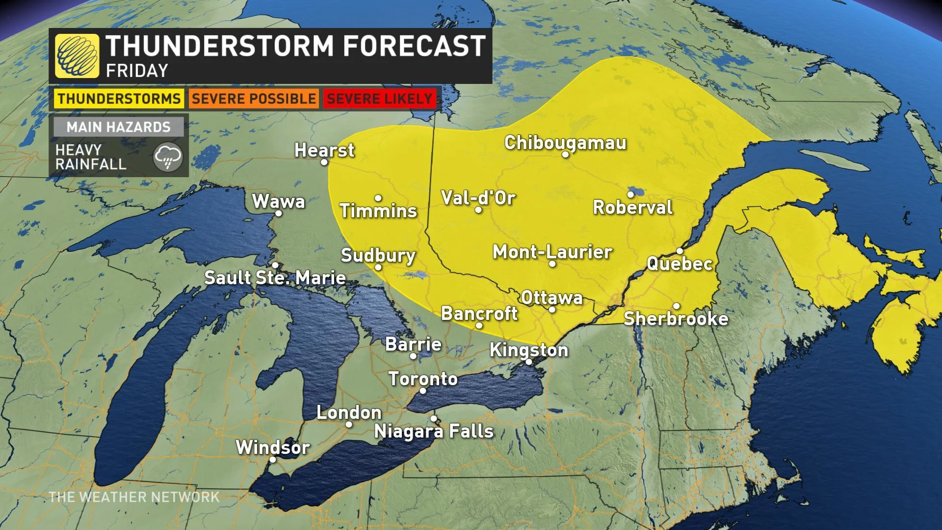
Non-severe storms expected for eastern areas Friday
Cooler trend into weekend, especially for cottage country
Stay up to date on ALERTS in your area
WATCH BELOW: TRACKING STORMS THURSDAY
STRONG STORMS CRACKLE TO LIFE
The first rains associated with the front moved into Huron/Perth and extreme southwestern Ontario through the morning commute, making their way to the GTA later in the morning, with parts of the metropolis still seeing showers in the afternoon.
Scary-looking storms triggered severe thunderstorm warnings for much of the east of the province as the afternoon wore on, including Ottawa itself. Downpours were reported as the storms moved through.
Elsewhere, late-afternoon storms in the Oshawa area brought not only rain, but reports of hail as well. The last severe thunderstorm warnings were dropped not long after 4:30 p.m.
This kind of pattern, with an upper-level low pressure centre over Ontario and Quebec, also favours the development of waterspouts on the Great Lakes.
SHOWERY FRIDAY, CLEARER SKIES FOR SATURDAY
That upper-level low will swing another round of showers -- and potentially thunderstorms -- into eastern Ontario for Friday while gusty northwest winds threaten a few lake-effect showers closer to Lake Huron and Georgian Bay. Much of southern Ontario can expect a dry close to the work-week, however.
FEELING LIKE FALL?
Thursday's cold front will usher down another shot of cooler, drier air -- one that will have morning temperatures feeling distinctly 'fall-like' into the weekend. While afternoon highs will recover into the 20s for many, morning temperatures will be in the low double digits for much of the region on Friday and Saturday, with low humidity adding to the autumnal feel.
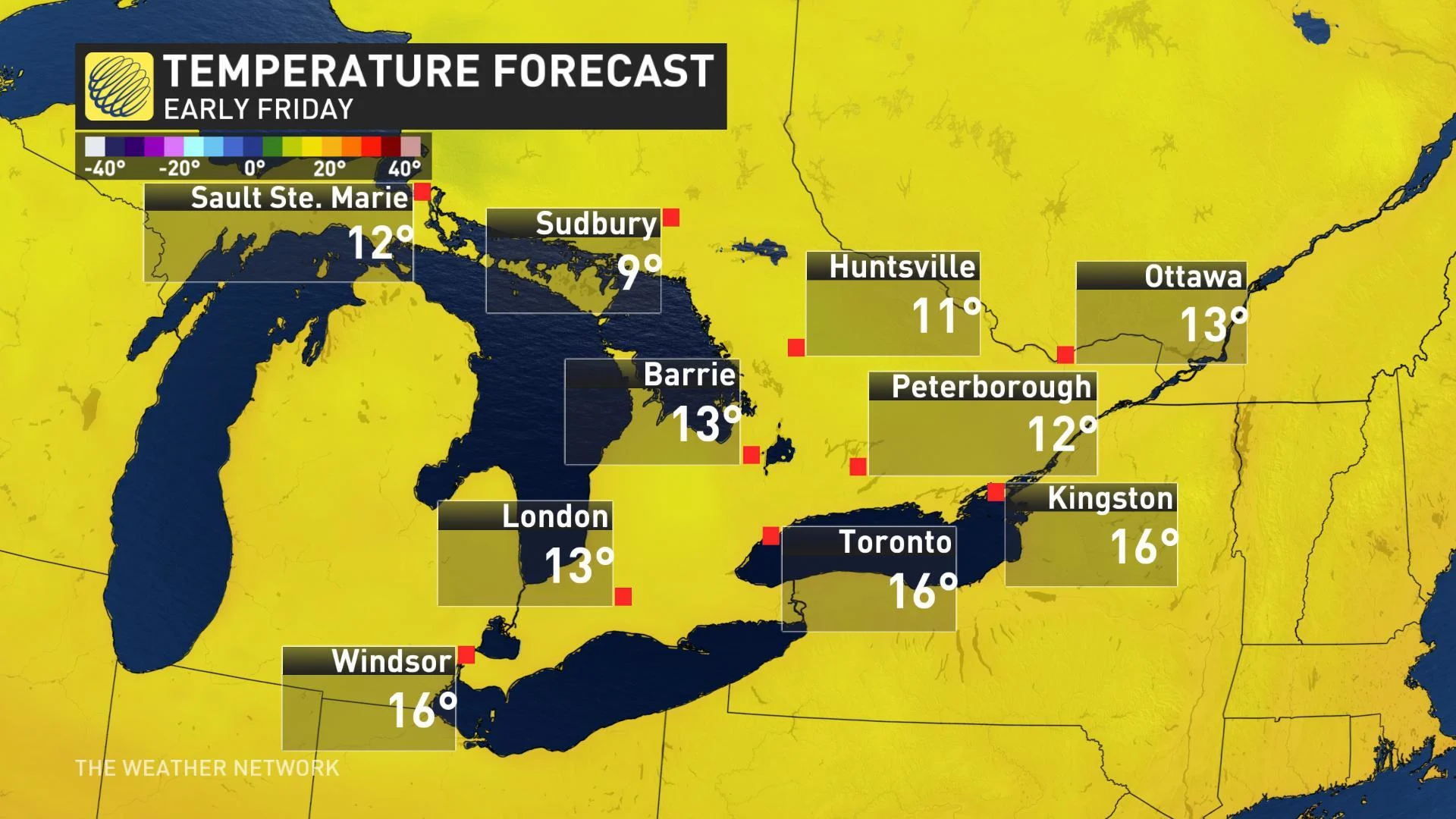
Those heading up to the cottage will face some cooler temperatures to start the weekend, though high pressure moving in means that at least Saturday's low-20s will be accompanied by mainly sunny skies.

If you're staying in the city this weekend, temperatures will rebound to near seasonal by Saturday, and everyone can expect a slightly milder Sunday.
"COOLEST WEATHER WE HAVE SEEN IN MONTHS"
Beyond the weekend, forecasters are watching for yet another shot of cooler air from the north, but a lot will depend on the exact timing of systems targeting the province.
"There's a lot of uncertainty as to whether we get a brief warm-up ahead of the cold front," says Weather Network meteorologist Dr. Doug Gillham. "Some models are quite warm across southern Ontario for Monday, while others have a cold front crossing the region before the warmer weather can reach us." The timing of the front, and when widespread rain makes its way through the region, could leave southern Ontarians reaching for jackets as what Gillahm calls "the coolest weather that we have seen in a couple of months" move in for mid-week.

For those not ready to bid farewell to summer just yet, however, there's good news. "It looks like the final 10 to 12 days of August will bring a return to above seasonal temperatures with that pattern continuing into early September," says Gillam.
Read Dr. Doug Gillham's complete national overview for the rest of summer, here.