UPDATED: Most of Canada still on track for cold winter

As winter officially begins, the seasonal forecast still looks to show a long and frigid winter for millions of Canadians this year.
December has been a changeable month across Canada. Most of Canada has experienced periods of high impact winter weather, but that has been followed by periods of milder weather as we have not yet locked into our winter pattern.
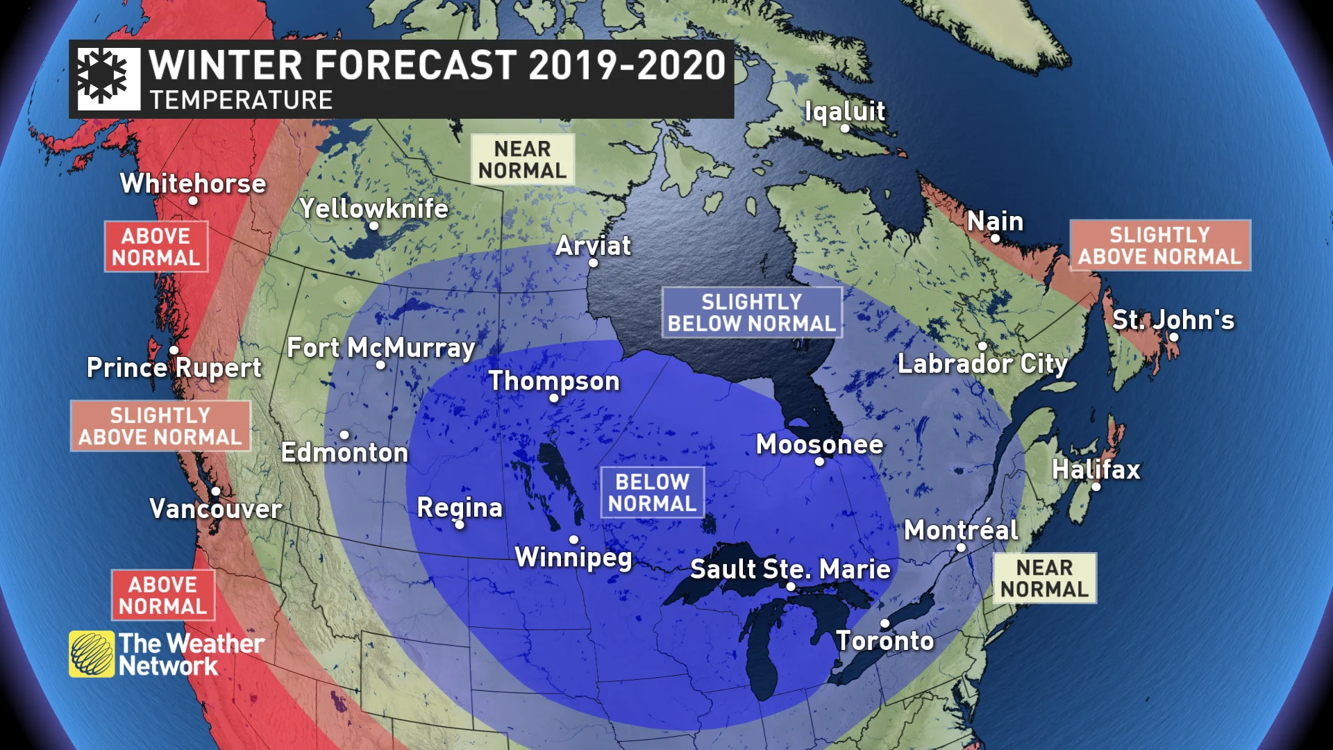
However, this is consistent with our winter forecast that we issued on November 17th and we believe that we are still on track with our winter forecast, which calls for a long and cold winter across most of Canada. Near normal or below normal temperatures are expected for most of the country. The only regions where temperatures are expected to tip to the mild side of normal are near the Atlantic and Pacific coastlines.
The map below shows our temperature forecast for the rest of December, January and February. Keep in mind that every region will go through periods that will be contrary to the dominant pattern for the season.
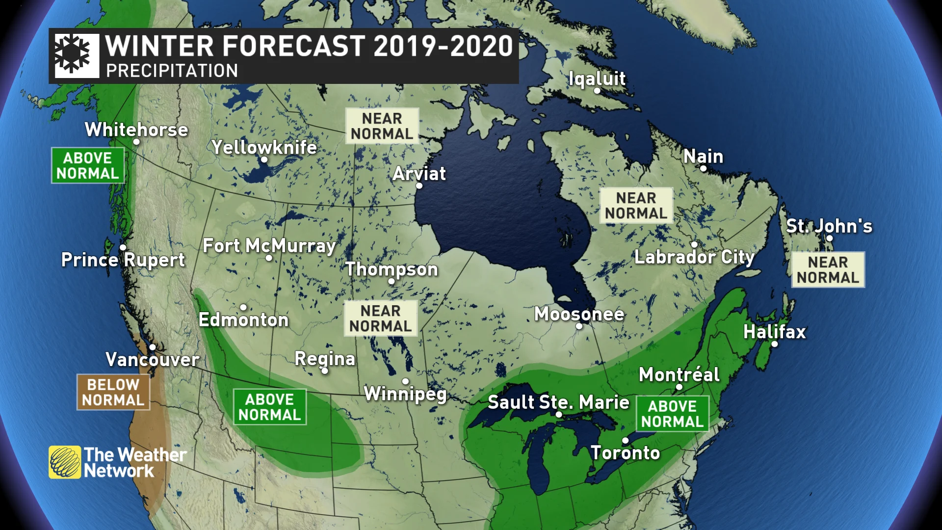
Near normal to above normal precipitation and snowfall are expected this winter across most of Canada. The most active storm track appears to target the Great Lakes and Atlantic Canada while the driest weather compared to normal is expected to include the south coast of B.C.
Here is a more detailed look at what our winter forecast means for each region of the country.
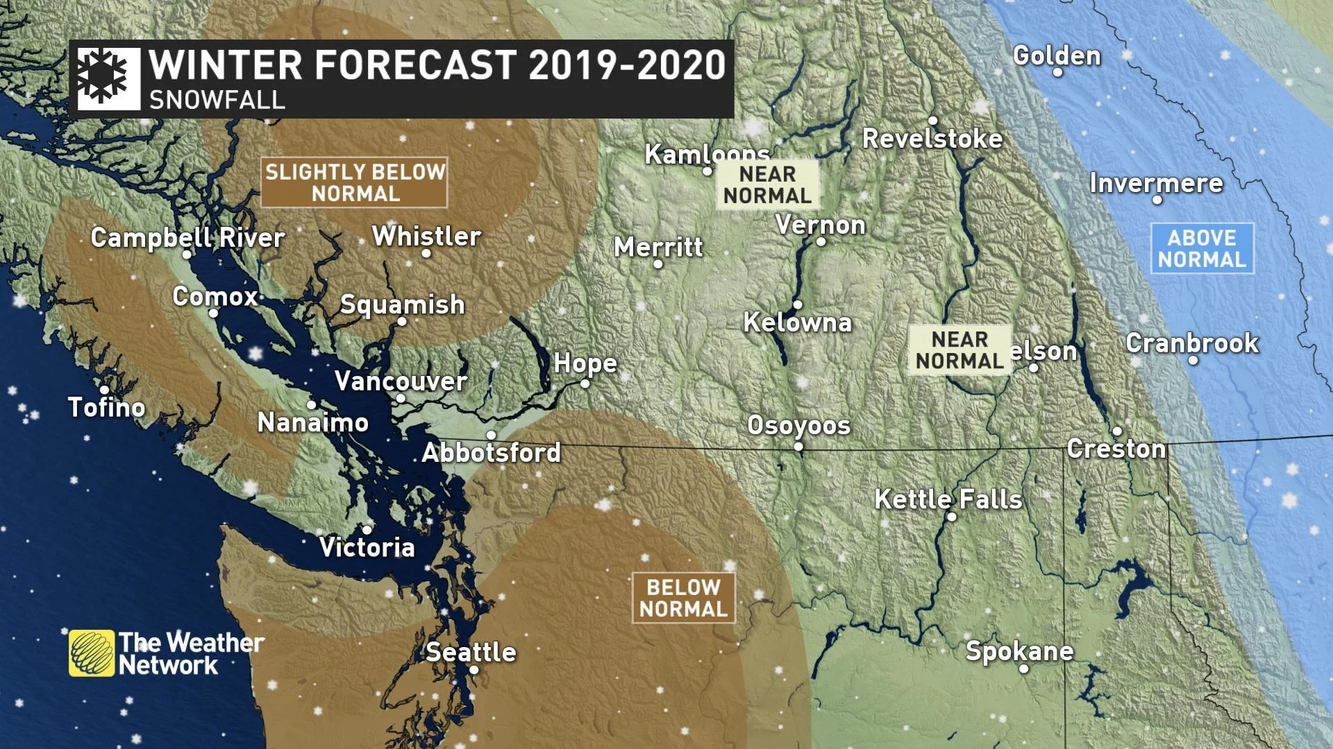
BRITISH COLUMBIA
Overall, a mild winter is expected along the B.C. coast and across much of northern B.C., while near normal temperatures are expected from northeastern B.C. to the southern interior. The north coast region is expected to see above average rainfall and alpine snow. For southern coastal areas, we expect fewer than normal rainy days. However, similar to what we have seen during December, the dry pattern will break down at times with the potential to see several week’s worth of precipitation in just 5 to 10 days. This should help the final precipitation totals approach seasonal.
CONFIDENCE INCREASES FOR BELOW NORMAL PRECIPITATION:
While a mild and dry forecast is not what skiers want to hear, there are reasons to remain optimistic about the ski season. We expect that the periods of active weather will coincide with the periods of cooler weather, allowing ski areas to pick-up substantial snowfall at times, much like we have seen during this past week. Also, we do not expect the “Pineapple Express” to be a regular feature of the winter, which will help to limit the threat for excessive rain in the alpine regions.
Meanwhile, near normal to above normal snowfall and near normal temperatures are expected for the central and southern Rockies.
PRAIRIES
A long and frigid winter is expected, with the most consistent cold weather across Saskatchewan and Manitoba. Alberta will be more changeable with periods of mild weather at times, which could come close to offsetting the bouts of severe cold. Near normal snowfall is expected across most of the region, but the foothills of the southern and central Rockies and parts of southern Alberta are have seen well above normal snowfall so far and will end up on the snowy side of normal for the winter as a whole.
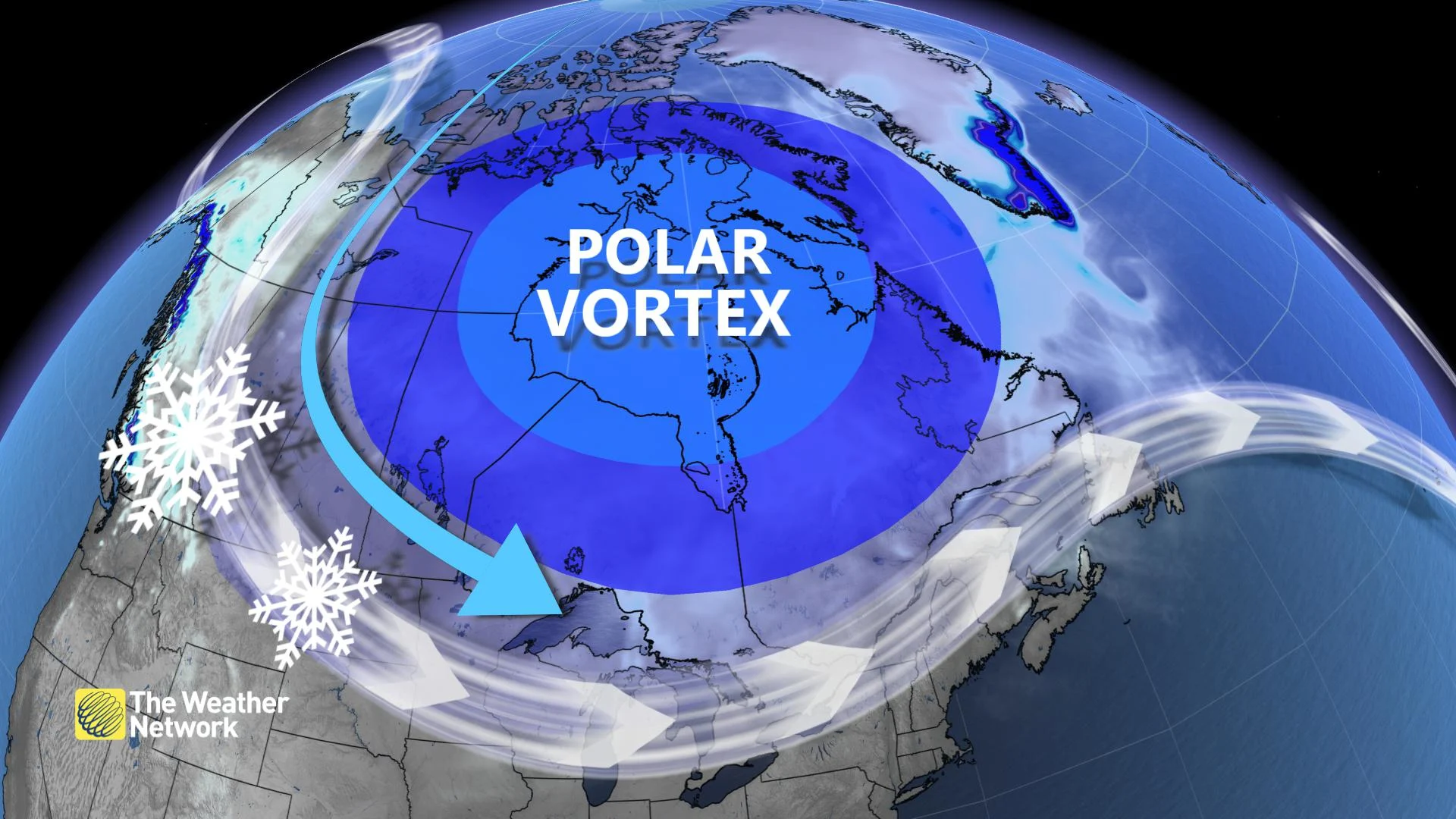
POLAR VORTEX TAKES HOLD FOR THE HEART OF WINTER ON THE PRAIRIES
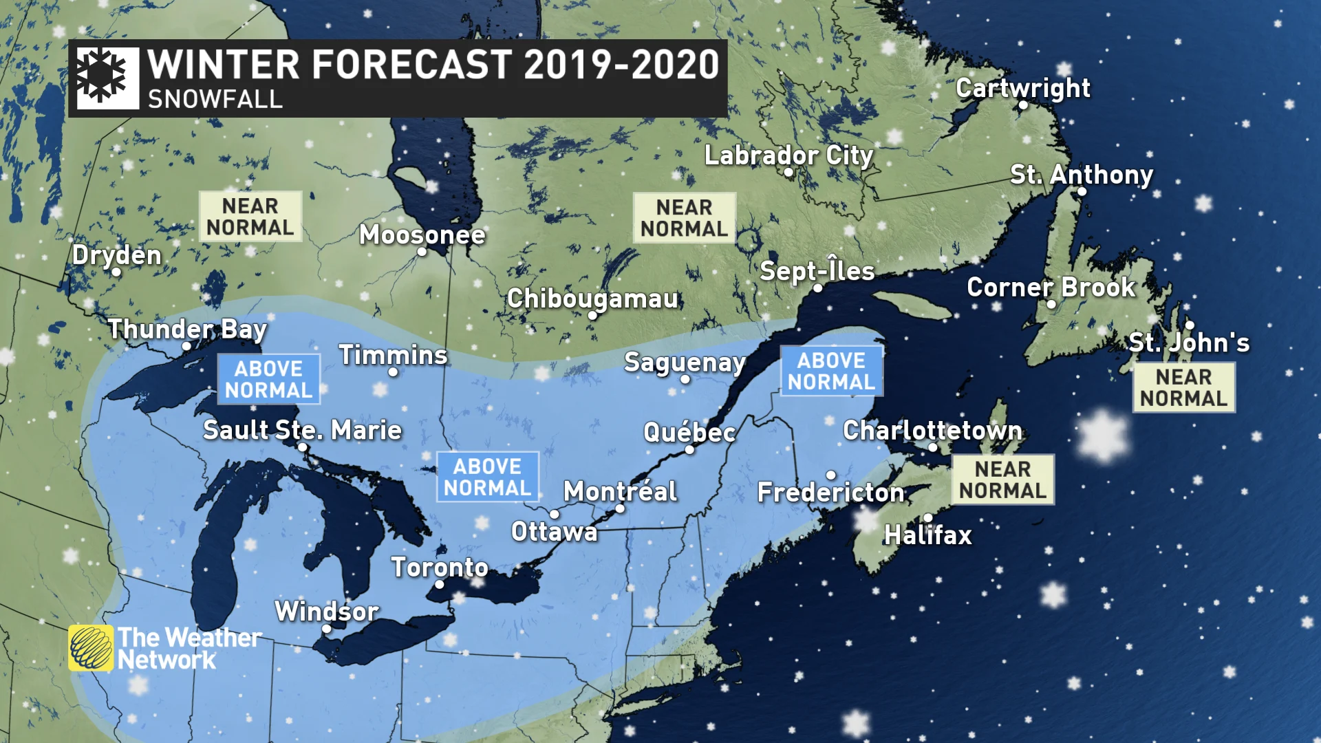
ONTARIO AND QUEBEC
A long, cold and snowy winter is expected across the region, though the pattern will relax at times with significant periods of milder weather. The cold weather will be most consistent during mid and late winter with extended periods of severe cold. An active storm track will likely bring above normal snow totals to much of the region, along with a risk for freezing rain at times, especially across southern Ontario and into southern Quebec. An abundance of lake effect snow is likely until increasing ice coverage on the Great Lakes becomes a limiting factor during February.
AN ABUNDANCE OF SNOW IN LAKE-EFFECT SQUALLS IN ONTARIO
Looking ahead to spring and beyond, water levels on the Great Lakes could be a major concern. Current water levels on the lakes are well above normal (even near record levels for this time of year). If we do see a cold and snowy winter across this region, then flooding along the shorelines of the Great Lakes will be a serious issue later in the spring and into the summer.
QUEBEC'S WINTER DEFINED AS 'COLD AND SNOWY'
ATLANTIC CANADA
After an inconsistent start to winter, this region will still see an abundance of winter weather, especially during the middle and end of the season with near to above normal snowfall totals and a heightened risk for ice.
CONSISTENT COLD LOCKS IN FOR JANUARY
However, southern and eastern coastal areas of Nova Scotia and Newfoundland, including Halifax and St. John’s, will experience periods of milder weather at times with a higher potential for rain. This should keep snowfall totals to near normal across the southern Maritimes despite above normal precipitation totals.
NORTHERN CANADA
A typical winter is expected across most of the region, including Yellowknife and Iqaluit with near normal temperatures and snowfall. This is in contrast to many recent winters which have been milder than normal. However, above normal temperatures are expected to dominate across western areas, including Whitehorse.
NORTHERN CANADA COULD EXPERIENCE COLDEST SEASON IN RECENT YEARS
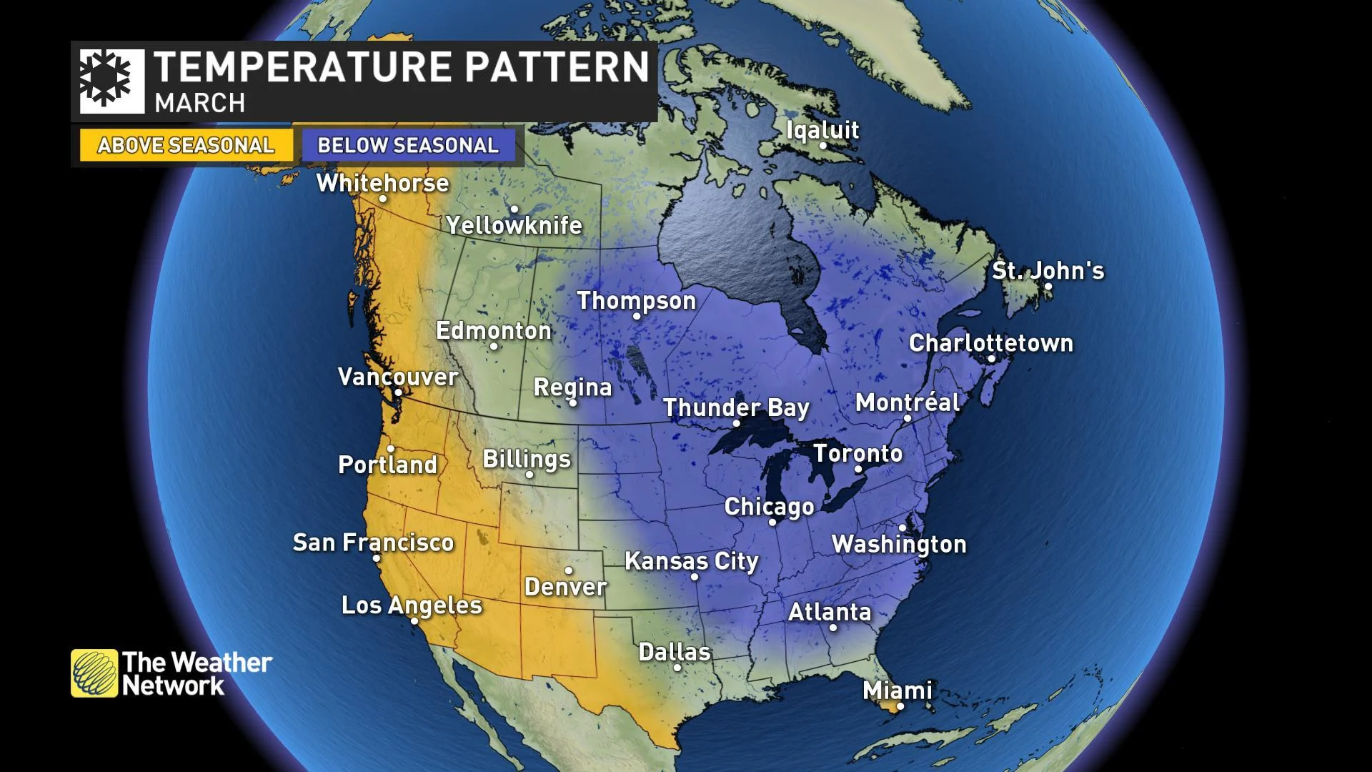
LOOKING AHEAD TO EARLY SPRING
Looking ahead to March, it looks like winter will hold on with a rather sluggish start to the spring season from the central Prairies to Atlantic Canada. Residents of British Columbia are typically the first to see the arrival of spring conditions and this year should bring an especially strong start to the season during March.