Three major factors put millions into dire flood scenarios

Some significant weather factors have contributed to the critical flood zones across eastern Canada.
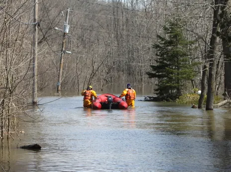
Spring flooding has been capturing headlines for weeks as several communities declare local states of emergency in an effort to provide some relief to the thousands of Canadians forced from their homes. More than 2,000 soldiers have been deployed to the flood zones in central and eastern Ontario, Quebec and along the St. John River in southern New Brunswick.
In many cases, flood waters have already reached historic levels with some areas, including the Ottawa River, still waiting to peak. According to the Insurance Bureau of Canada, this year's record flooding could push "losses from extreme weather" to more than $1 billion dollars for homeowners in affected areas.
THE PERFECT STORM OF SNOWPACK, APRIL PRECIPITATION AND TEMPERATURES
As the flood fight continues and eastern sections of the country remain desperate for any sort of improvement, we take a look at a few of the major factors that have pushed water levels to the brink and beyond this spring.
NO GOING BACK: HERE'S how Canadian lakes and oceans will change throughout the 21st century
SNOWPACK: IT HUNG ON FOR TOO LONG
If you ask anyone living in Ontario's cottage country, this winter was a long one. Not because of any extreme or record snowfall amounts per se, but because of the snow simply hanging on for too long. The snow that started to coat surfaces way back in the fall never left.
It's not uncommon to see early snow squall events impacting the region in the fall, combined with a few decent storms that usually make for a White Christmas. It's also typical however, to get a brief melt through the January and February time period, which provides some relief and a more gradual snow melt. This did not happen this year, and as a result, there were still several feet of snow heading into the spring season.
It's the same story for Quebec, with a heavy snowpack recorded in the Laurentians that ultimately drains into the Ottawa River basin. The snow hung on with below seasonal temperatures well into the month of April.
"So once it did start to melt with the arrival of some warmer temperatures, there was a lot of water that had to go somewhere," says Weather Network meteorologist Jaclyn Whittal. "Above average rainfall also added more moisture to the snowpack as we entered into the melting season."
SEE IT: THIS IS SOMETHING THAT HASN'T HAPPENED IN 100 YEARS
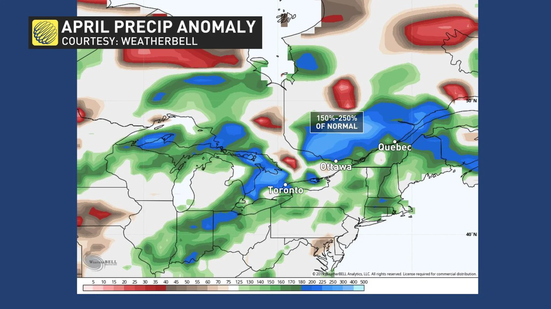
WELL ABOVE AVERAGE APRIL PRECIPITATION
Another major factor to take into account when analyzing a flood season is to look back at monthly precipitation amounts relative to what's normal.
"And it's important not to just look at precipitation that has fallen over the flooded area, but the entire region that could impact the river," says meteorologist Kelly Sonnenburg, adding in the case of the Ottawa River, we're looking at data over the entire Ottawa River drainage basin.
The Ottawa River Basin saw approximately 150%-250% of the 'normal' or average amount of April precipitation. Looking back at 2019 so far (January through April), precipitation as a whole has tipped at or just above normal as well.
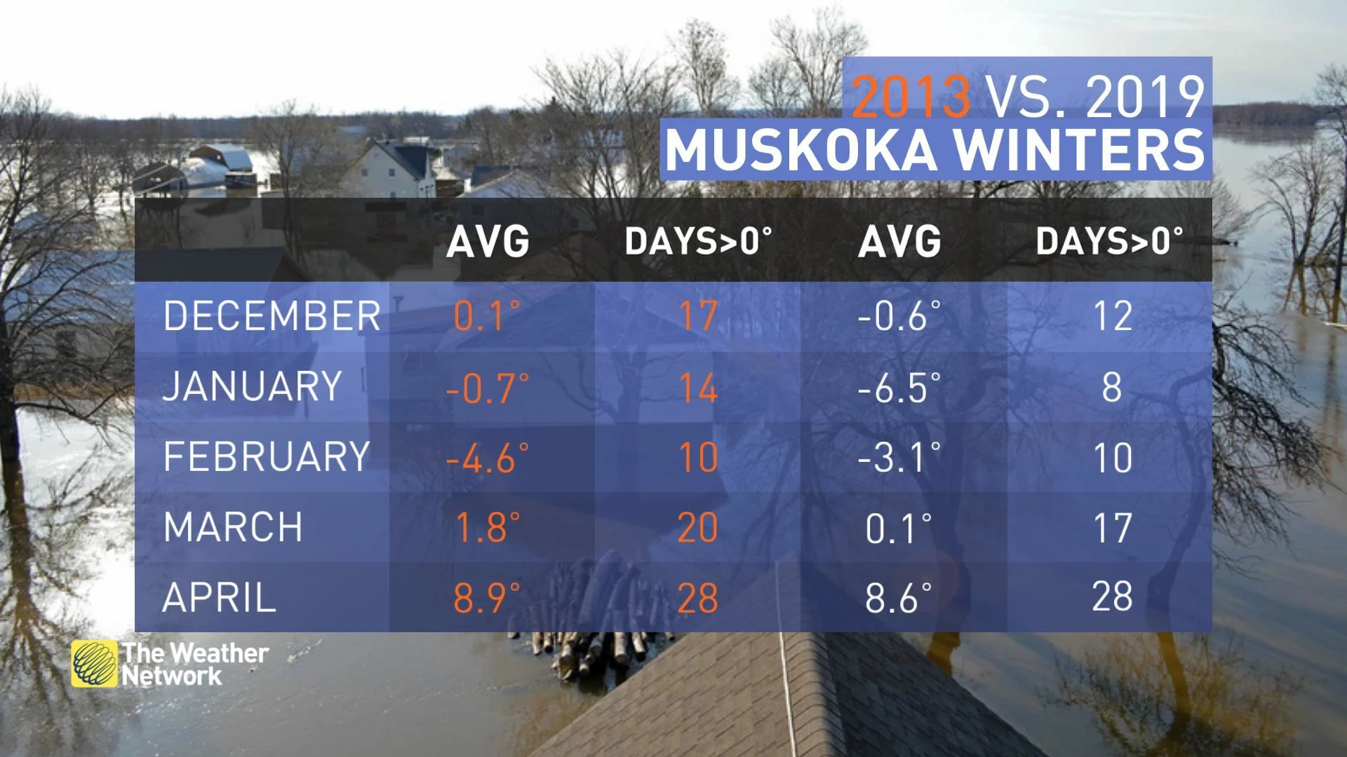
TEMPERATURES
It's also important to look at the overall temperature pattern, not only in recent weeks, but over an entire season. Observing the winter temperature trend across eastern Ontario and Quebec, it was clear that temperatures trended colder than normal. With no significant mid-winter thaw, this allowed the snowpack to continue to grow.
While temperatures have continued to trend cooler than normal this April as well, the 'normal' or seasonal temperatures for this time of year are well above the freezing mark, which means snow melt will still occur. Temperatures don't need to be extremely warm to result in major flooding.
Comparing the siginificant flooding that occurred across cottage country in 2013 to that of 2019, the temperature trend was very similar with the exception of January 2019 being much colder than January 2013.
With files from Weather Network meteorologist Jaclyn Whittal, Kelly Sonnenburg, Nicole Karkic