Triple-dip La Niña and polar vortex to deliver a frigid start to winter

For the third year in a row, the primary driver for Canada’s winter weather pattern will be La Niña. Here's how it could impact the season ahead across the country.
Warm weather has dominated across Canada through most of the fall season. However, the past few weeks have featured an abrupt transition into a period of wintry weather for most Canadians. Is this sudden flip to cold and snowy weather a warning of what’s to come this winter? Let’s take a look at what we expect from the forecast during December to February.
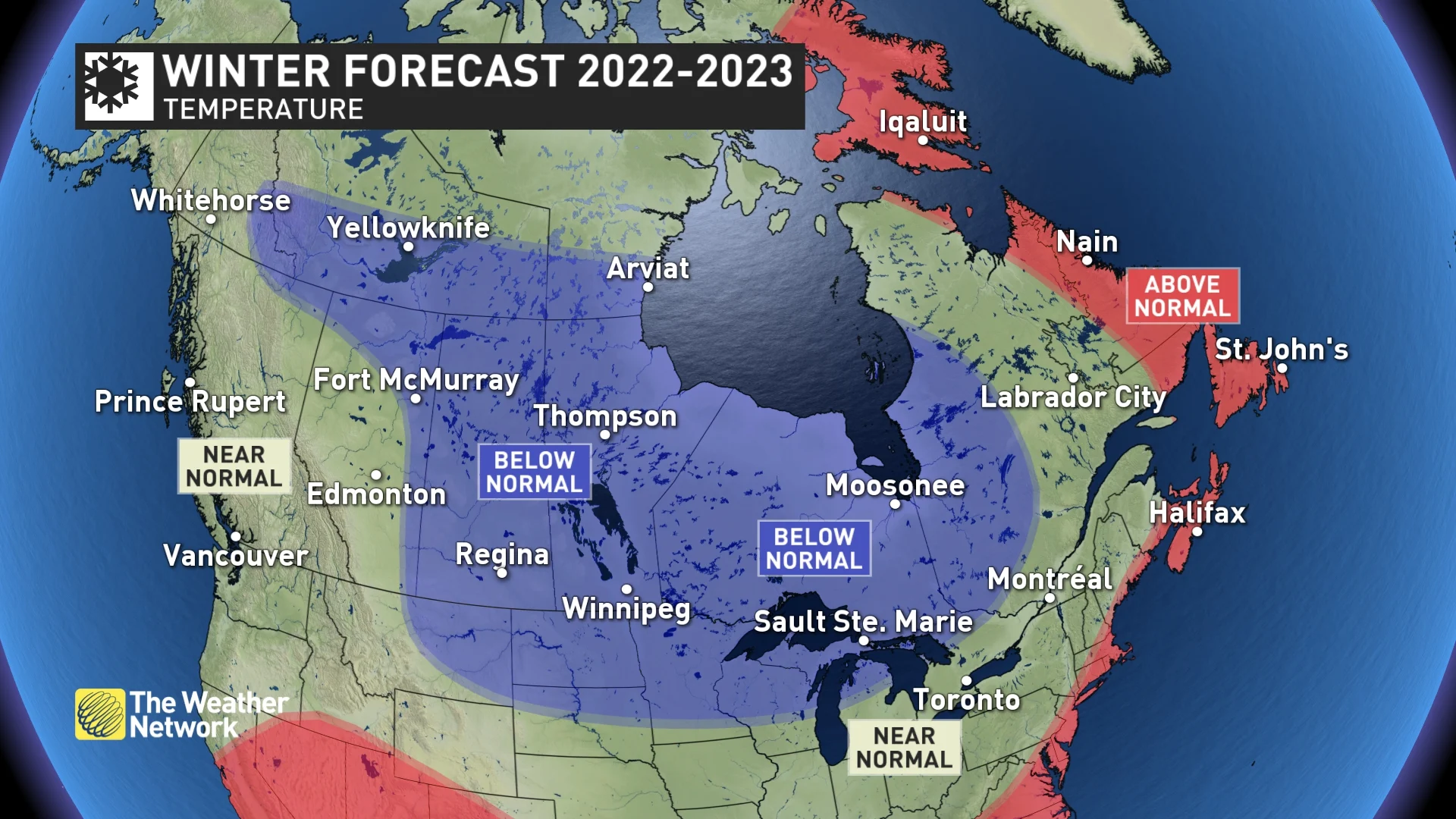
A strong start to the winter season is anticipated, with colder-than-normal temperatures across most of Canada during the month of December.
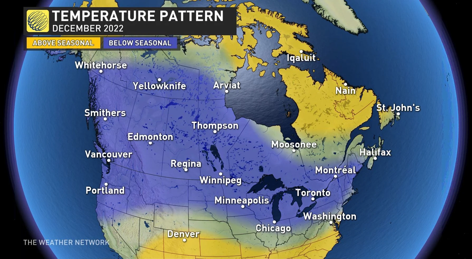
For the third year in a row, the primary driver for Canada’s winter weather pattern will be La Niña. This is just the fourth time on record we’ve seen a La Niña event persist for three consecutive years. In addition, a piece of the polar vortex is expected to be located over northern Canada, providing an abundant source for Arctic air that should frequently plunge south and spread across much of the country during December.
We expect that once we get into January and February, however, winter will take a couple of breaks with periods of mild weather, especially from southern Ontario to Newfoundland and Labrador.
At times, we expect that the national weather pattern will look like what we often see during La Niña winters, with frigid weather found across western Canada and milder temperatures from the Great Lakes to Atlantic Canada.
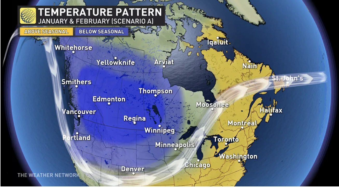
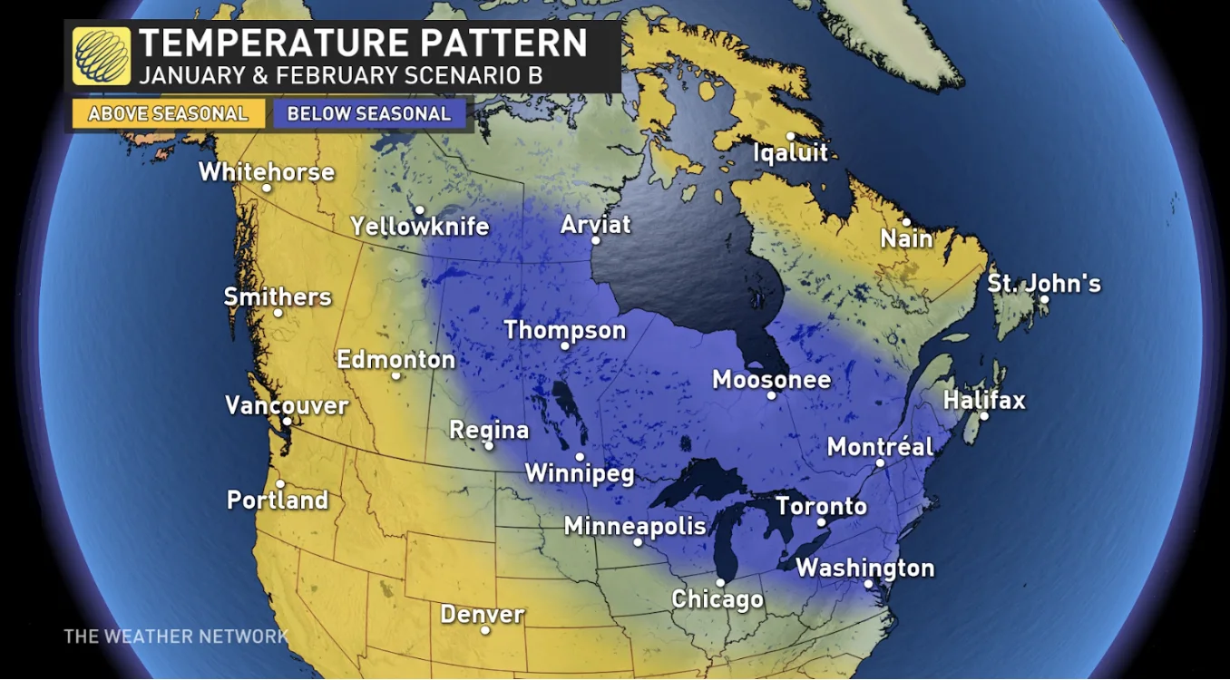
However, we expect that at times the frigid weather will shift east, and stretch from the eastern Prairies to Quebec with milder weather across B.C. and Alberta. This is much like what we saw during January and February of last winter.
The result for many Canadians will be a two-faced winter which will feature extended periods of harsh winter weather, and extended periods of milder weather that may leave you wondering, “what happened to winter?”
When we look at the big picture for the season as a whole, we expect that temperatures will be near to below normal across most of Canada, but parts of Atlantic Canada and Nunavut will be warmer than normal.
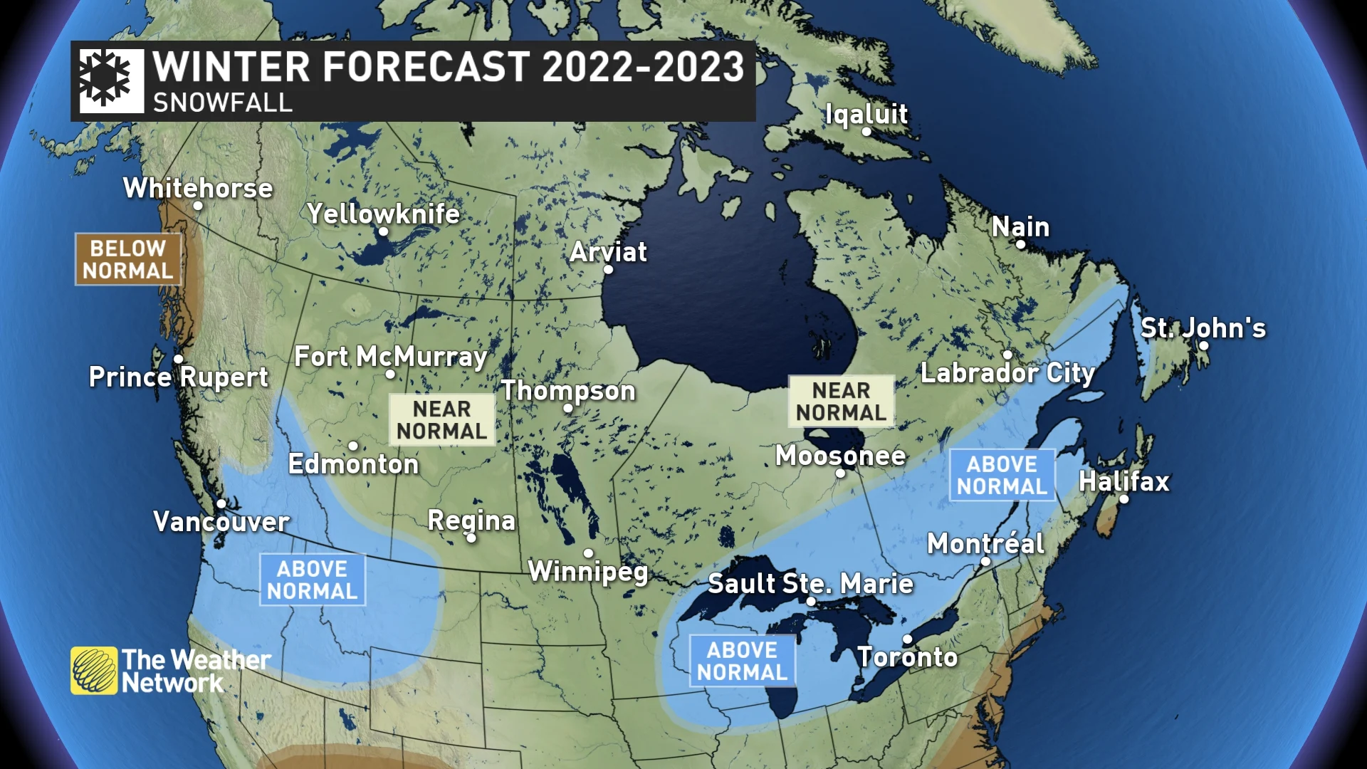
The La Niña pattern in the Pacific Ocean is expected to support an active storm track across southern Canada, leading to above-normal precipitation and snowfall for southern parts of B.C., Alberta, Ontario, Quebec, and into Atlantic Canada.
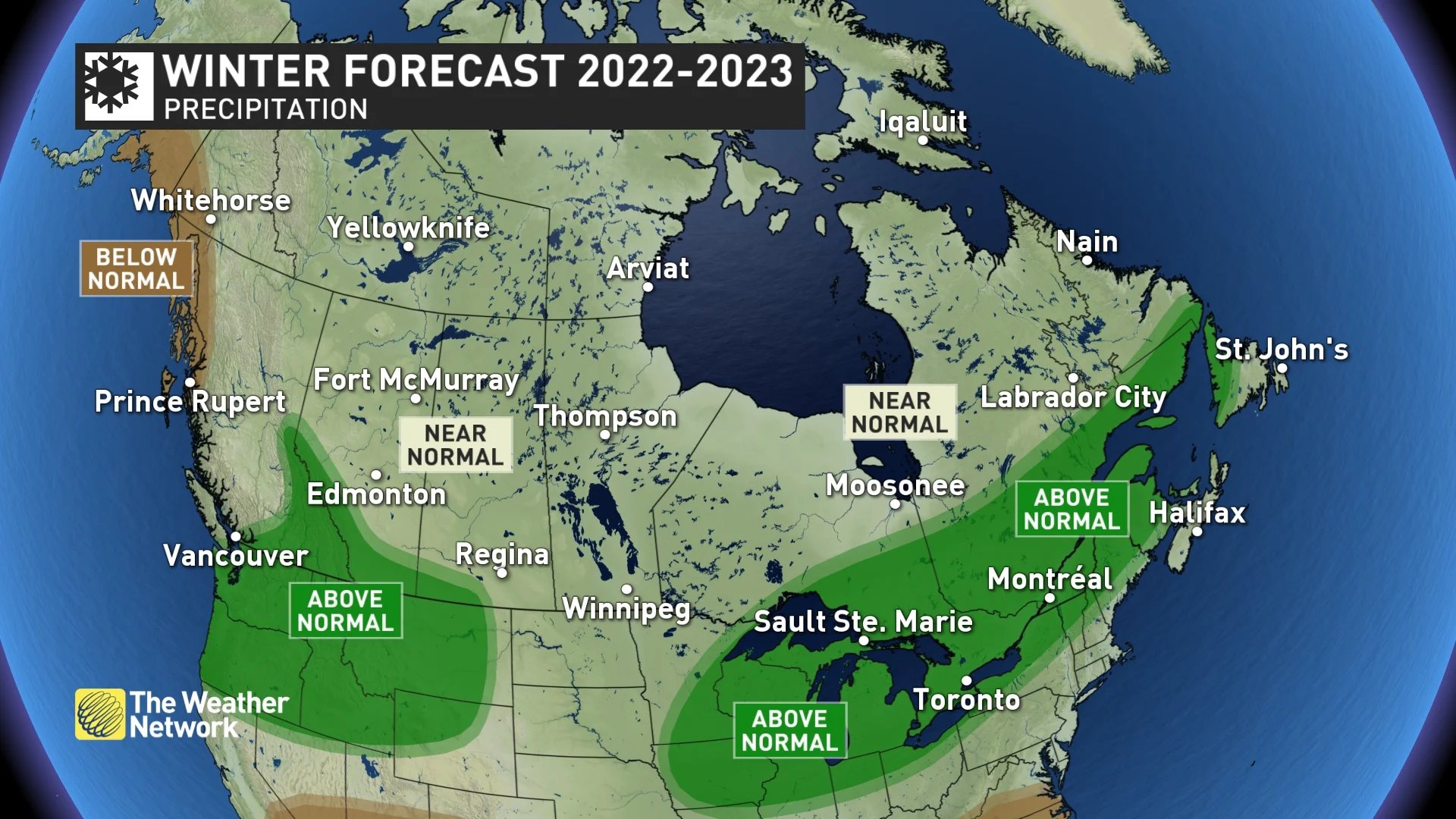
However, across southern parts of Atlantic Canada, southern Ontario, and even into southern Quebec, several of our winter storms will bring a messy mix of snow, ice and even rain. So, while we still expect an abundance of snow across much of the region, it is possible that southern areas will end up with below-normal snowfall.
Here’s a more detailed look at what we can expect across the country during the upcoming winter season:
British Columbia
A come-and-go winter is expected for B.C., with periods of mild weather and extended periods of colder-than-normal temperatures, with a heightened risk for a couple periods of severe cold. This will result in near-normal or slightly colder-than-normal temperatures for the season as a whole.
Below-normal precipitation totals are expected for the northern and central coast, but an active storm track is expected for southern B.C., which should bring above-normal precipitation totals to most of this region. This should also bring an abundance of snow to the alpine regions, and at times we expect substantial snowfall across lower elevations as well, including Vancouver, Victoria and the Okanagan Valley.
A few atmospheric river events are expected, but the “Pineapple Express” is less likely. This means we should see fewer storms that bring rain to alpine regions. Additionally, at this point it also looks like temperatures during early spring will be on the cool side of seasonal. This should set the stage for an excellent and extended ski season.
B.C.'s 2023 Winter Forecast: Could La Niña mean more snow?
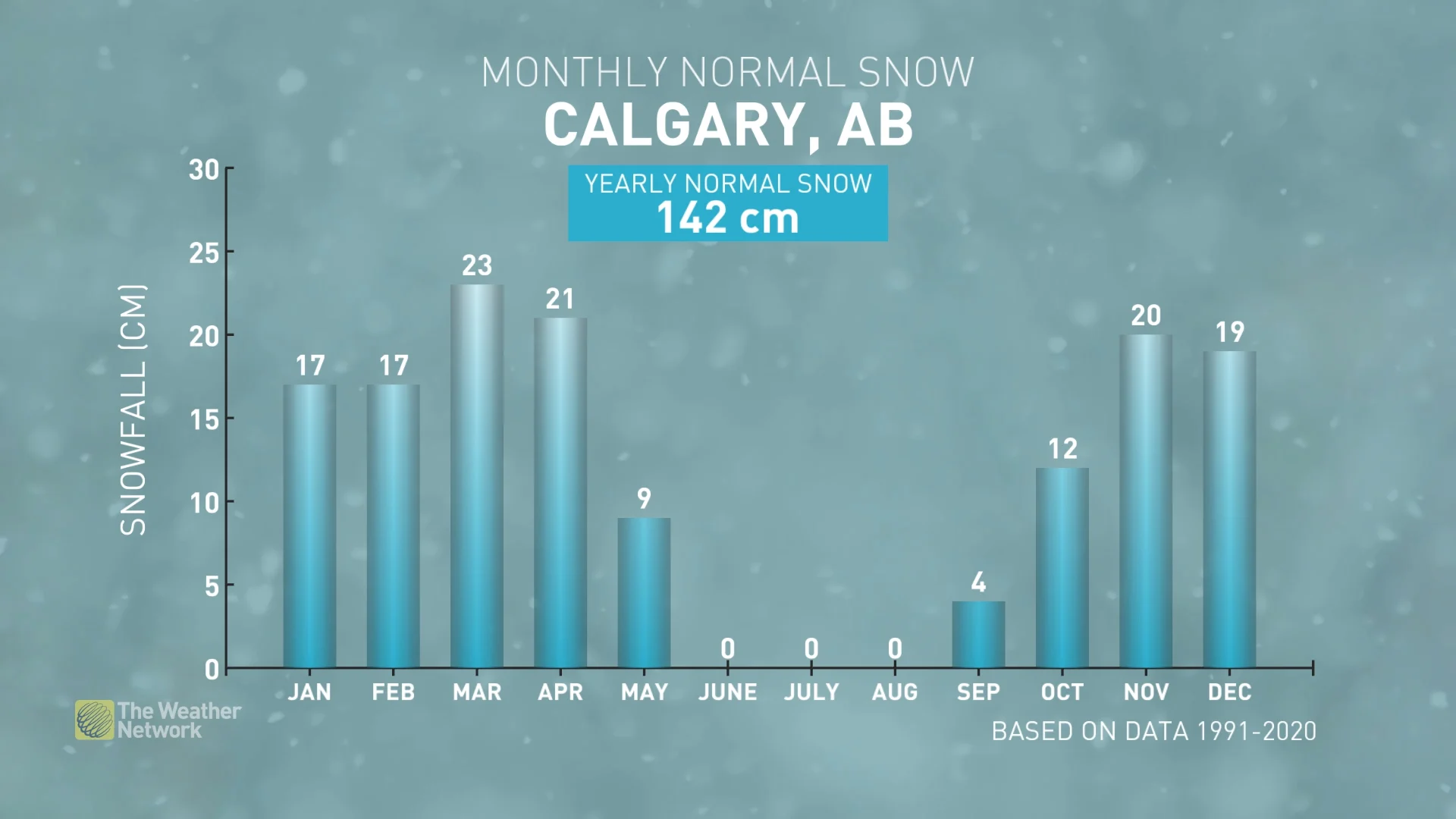
Alberta
A changeable winter is expected across Alberta, which will include periods of severe cold and extended periods of milder weather. This should result in near-normal temperatures for the season as a whole across most of the province, including Edmonton and Calgary. However, eastern and northern parts of Alberta could tip to the cold side of normal.
A snowy winter is expected across southern Alberta with near-normal snowfall elsewhere across the province. The changeable and active pattern will also bring a heightened risk for blizzard conditions when Arctic air plunges south into the region.
Saskatchewan and Manitoba
A frigid winter is expected across the central and eastern Prairies with a heightened risk for periods of severe cold. There will be periods of milder weather at times, but overall we expect a classic Canadian winter for this region with colder-than-normal temperatures, near-normal snowfall, and a heightened risk for blizzard conditions at times.
WATCH BELOW: Blizzard risk heightened for this part of the Prairies
Ontario
The first week of December will bring changeable temperatures, but overall we expect a quick start to winter, with colder-than-normal temperatures dominating into the holidays and a few more rounds of heavy lake-effect snow. However, winter will take a break at times during January and February with the potential for an extended thaw across southern areas.
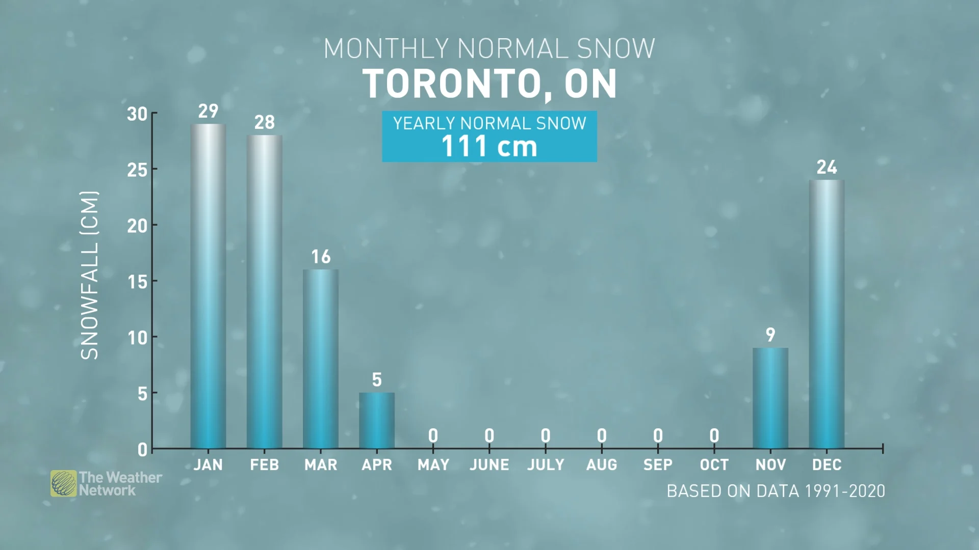
An active storm track should bring above-normal precipitation totals to the region, including an abundance of snow for ski areas. However, several systems will bring a messy mix of snow, ice, and even rain at times.
Ontario's 2023 Winter Forecast: What a 'locked La Niña' means for snow totals
Quebec
A strong start to winter is expected with colder-than-normal temperatures dominating during most of December, though we will see changeable temperatures during the first week of the month. Winter will take a break at times during January and February, however, with the potential for an extended thaw across southern areas.
An active storm track should bring above-normal precipitation and snowfall to the region, including an abundance of snow for ski areas. However, several systems will bring a messy mix of snow, ice, and even rain periodically—especially across southern parts of the province.
Quebec's 2023 Winter Forecast: What a varied storm track is set to bring
The Maritimes
A changeable winter is expected across Nova Scotia, P.E.I, and New Brunswick, but the back-and-forth temperature swings should tip to the warm side of normal across southern parts of the region for the season as a whole. For the remainder of the region, temperatures are expected to balance out to near normal.
The Maritimes typically see an active storm track during the winter, and this year will be no exception. Ocean water temperatures are once again much warmer than normal across the western Atlantic, and that will help to provide extra fuel to many storm systems that impact the region.
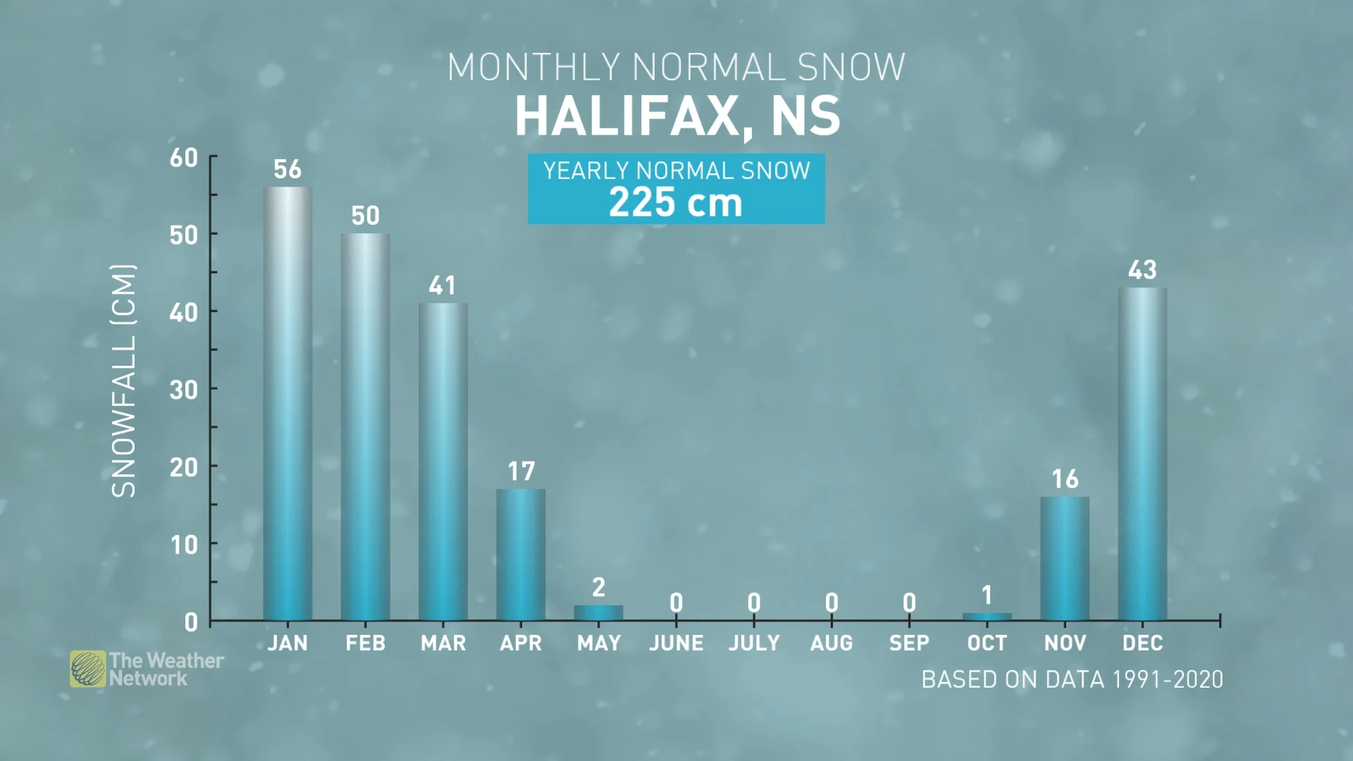
This winter will bring a higher potential for storms to bring a messy mix of snow, ice, and rain rather than just primarily snow as the storm track will allow several systems to pull warmer air into the region. We also expect fewer than normal traditional nor’easters.
Atlantic Canada's 2023 Winter Forecast: What a 'triple-dip' La Niña means for snow
Newfoundland and Labrador
A changeable winter is expected, but the back-and-forth temperature swings should tip to the warm side of normal across the region.
Winter is typically a stormy time of year across the region and this winter will fit that description. As a result, we expect near-normal or slightly-above-normal precipitation totals.
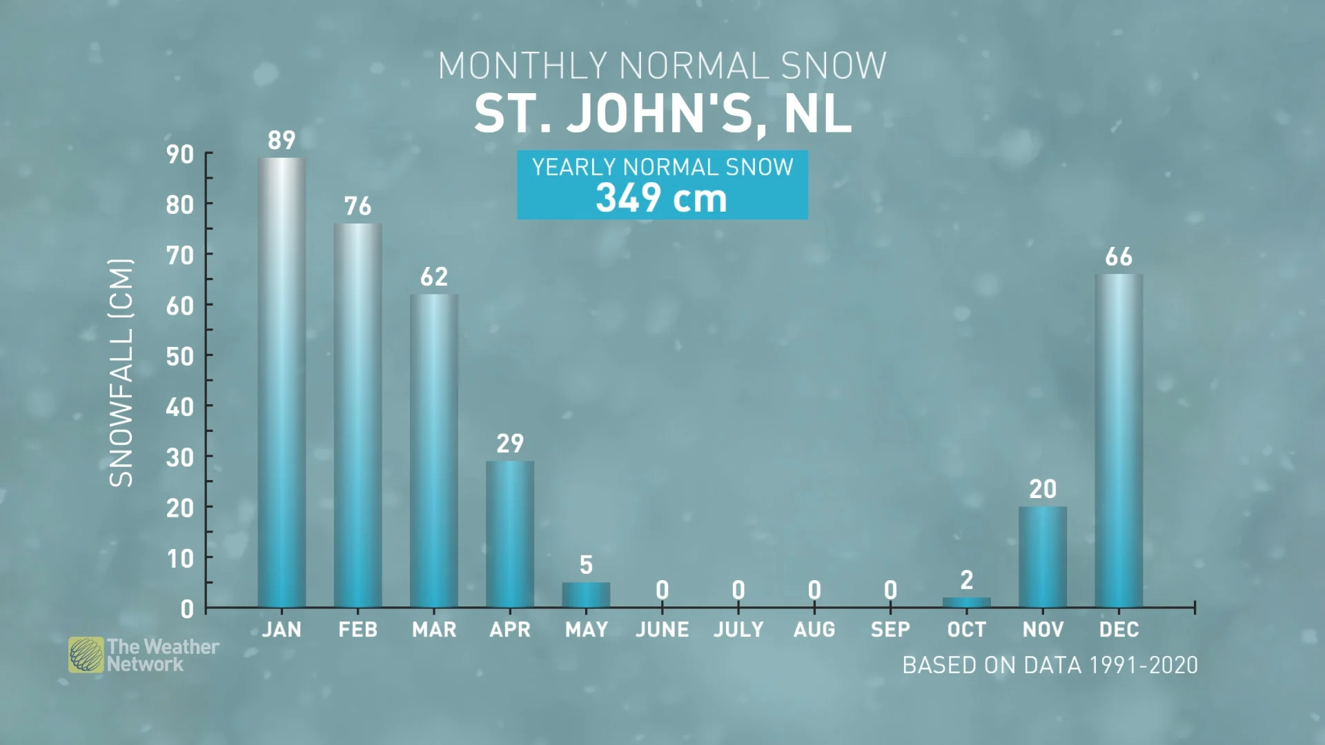
Also, ocean water temperatures are much warmer than normal again across the western Atlantic, and that will help to provide extra fuel to many storm systems that impact the region and bring the risk for messy systems that bring snow, ice and rain, especially to southern and eastern parts of the province. We also expect fewer than normal traditional nor’easters, but any nor'easters that do develop will pack quite a punch.
Northern Canada
A colder-than-normal winter is expected across southern parts of the Northwest Territories and southern Nunavut. However, above-normal temperatures are expected across eastern parts of Nunavut, including Iqaluit. Near-normal temperatures are expected elsewhere.
Most of the region will see near normal precipitation totals.