SUMMER FORECAST: A look ahead at Canada's most anticipated season

The Weather Network's official 2020 Summer Forecast reveals what Canada can expect for the heart of the summer season.
After a sluggish spring, summer weather burst onto the scene across much of Canada.
Many Canadians saw an abrupt transition from record cold to record heat during the month of May. Is this the start of a long and oppressively hot summer? To answer this question, The Weather Network has released its Summer Forecast for the months of June, July, and August with an overview of what Canadians can expect for the upcoming season.
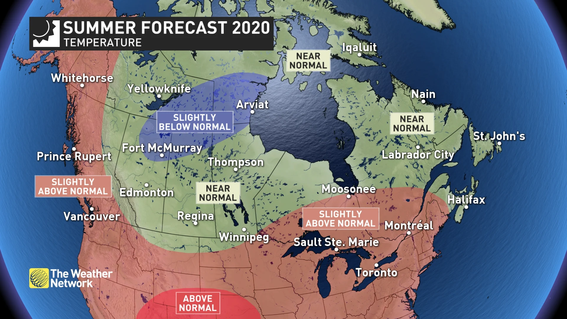
Our summer forecast highlights an abundance of warm weather across most of Canada with near normal or slightly above normal temperatures expected for much of the country. However, we do not think that this will be an oppressive summer with relentless heat for most of Canada.
June will feature swings between mid-summer warmth and fresh spring-like weather before more consistent heat takes over for July and August. Heat waves are likely, especially for southern Ontario and Quebec, but periodic breaks in the heat will keep the summer from being an all-out scorcher.
Most of Canada should receive close to normal amounts of rainfall during the summer. However, an active pattern is expected across parts of the Prairies, northwestern Ontario and into parts of the Great Lakes region with numerous thunderstorms and above average rain totals.
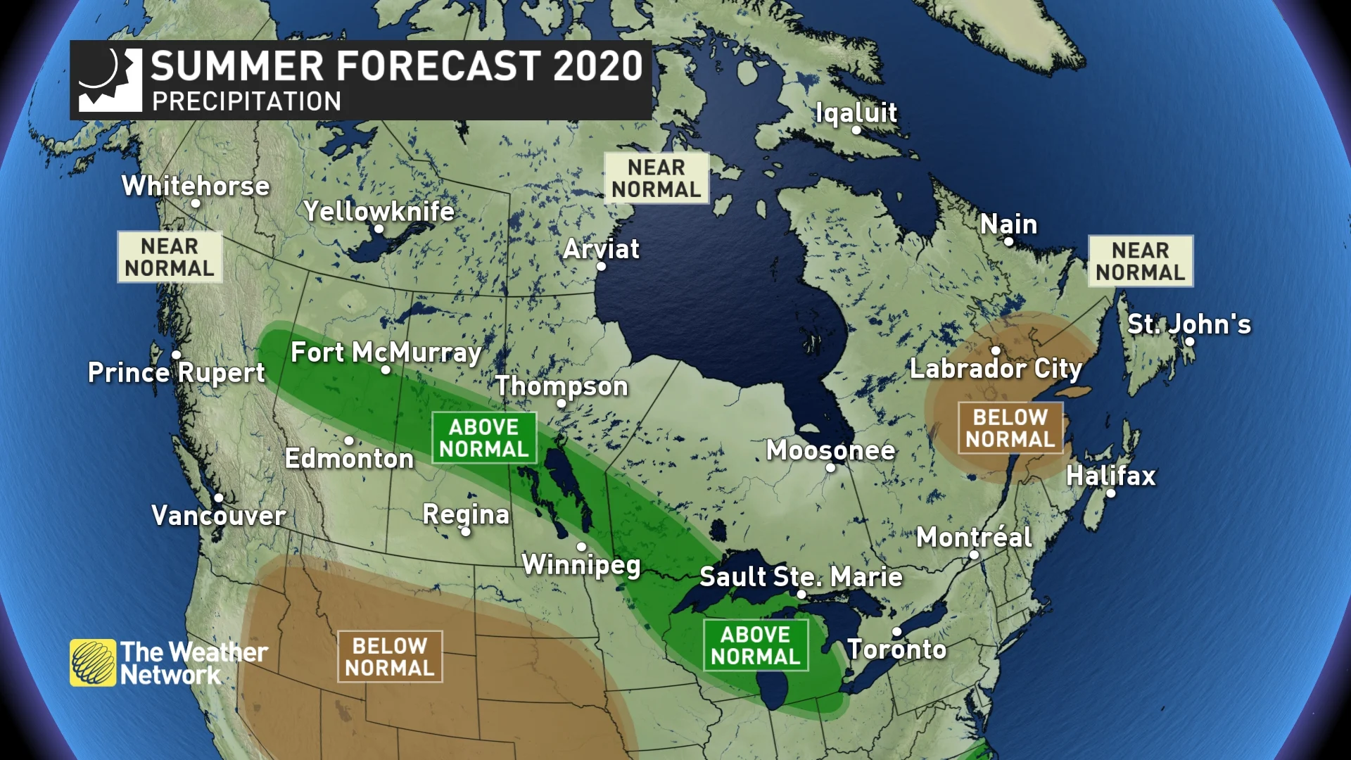
A dry summer is expected for parts of eastern Quebec and we are concerned that this will extend into parts of Atlantic Canada. However, an active tropical season is expected and any systems that tap into tropical moisture will have the potential to bring excessive rainfall and bring the final numbers to near normal.
It’s important to keep in mind that summer precipitation is notorious for being highly variable over short distances and it is inevitable that localized areas will miss out on the showers and thunderstorms that occur in surrounding areas. In addition, localized storms can bring torrential rain to areas where drought dominates a season.
Below is a more detailed look at the conditions that we expect across Canada this summer:
BRITISH COLUMBIA
Summer will get off to a slow start across British Columbia with temperatures on the cool side of normal for a large part of June. We then expect that very warm weather will dominate during the heart of summer. Near normal rainfall is expected along with the typical risk for wildfires. However, summer heat may come to an early end with the potential for cooler than normal temperatures to end the season, especially across the interior of British Columbia.
WATCH BELOW: COULD RING OF FIRE PATTERN MEAN MORE STORMS FOR B.C.?
ONTARIO & QUEBEC
A warm and humid summer is expected, but June will still include periods of cooler, refreshing weather. July and August will feature extended periods of hot, sunny and dry weather, but oppressive heat will not dominate the entire summer. Periods of cooler weather will break up the heat at times, and thunderstorms will help to deliver rain, which could be locally excessive.
WATCH BELOW: HOT PATTERN UNDERWAY, BUT WILL THAT SPELL MORE STORMS FOR ONTARIO?
It is possible that the active storm track into the Great Lakes region will primarily stay south and west of the Canada/U.S. border. If that occurs, then southern Ontario will see a dry summer. However, if the active storm track shifts to the north and east and cuts across southern Ontario, then we will see a wetter summer for parts of the region.
A strong finish to summer is expected with warm weather continuing through much of September.
WATCH BELOW: A CLOSER LOOK AT QUEBEC'S SUMMER FORECAST
ALBERTA
A typical summer is expected across most of the province with changeable conditions. Periods of hot, sunny and dry weather are likely, but a stormy pattern at times (especially during June) and shots of cooler weather will keep temperatures and precipitation near normal for most areas.
June looks like it will be an especially stormy month across most of Alberta, and an active storm track could continue to bring above normal rainfall to areas near and north of the Yellowhead Highway during July and August. A cooler summer is expected across far northern areas, especially late in the summer when the weather could turn colder than normal across most of the province.
WATCH BELOW: COOLER WEATHER LIKELY FOR PARTS OF THE PRAIRIES
SASKATCHEWAN AND MANITOBA
A typical summer is expected across most of the region. Periods of hot and dry weather are likely, but an unsettled and stormy pattern at times and shots of cooler weather will keep temperatures and rain totals near normal for most areas. An active storm track could bring above normal rainfall to areas near and north of the Yellowhead Highway and through the interlake region of Manitoba. A cooler summer is expected across far northern areas and cooler weather could spread into western parts of the region during August.
ATLANTIC CANADA
A cool start to the season during June will give way to a warm summer with near normal to slightly above normal temperatures and abundant sunshine during July and August. Near normal rainfall is expected for much of the region, but we are concerned that much of the region will turn rather dry for a while during the summer, especially across northern New Brunswick. However, we are also closely watching the tropics as a very active hurricane season is expected. Any system that taps into tropical moisture will have the potential to bring excessive rainfall and bring the final numbers to near normal.
WATCH BELOW: HOW LONG WILL COOLER TEMPERATURES LINGER ACROSS ATLANTIC CANADA?
NORTHERN CANADA
A warmer than normal summer is expected for the Yukon, but near normal to slightly below normal temperatures are expected for the N.W.T. and Nunavut. Near normal precipitation is expected across most of the region, but that certainly does not eliminate the threat for wildfires.