B.C.: Severe storm risk, but coupled with some welcome rain

Thunderstorms are set to fire up within much of the B.C. interior, with the risk also stretching over northern Vancouver Island. The so-far parched province has seen some elevated wildfire risk so far this season, but below-seasonal temperatures and rain from this system will somewhat help the situation. For more on what to expect, and a peek at the weekend, see below.
Summer revealed! Visit our Complete Guide to Summer 2019 for an in-depth look at the Summer Forecast, tips to plan for it and much more
WEATHER HIGHLIGHTS:
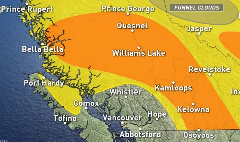
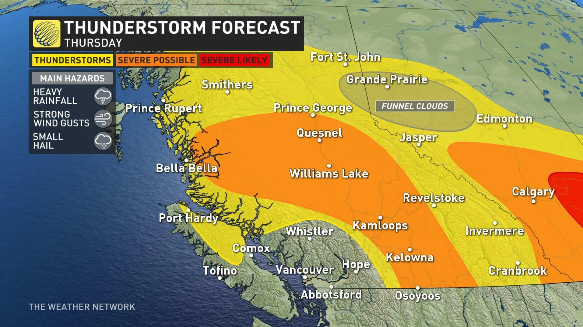
Chance of isolated severe thunderstorm risk in much of the Interior and northern Vancouver Island.
Heavy rain, strong wind and small hail are the biggest threats
Below-seasonal temperatures continue Thursday
The unsettled pattern continues into start of long weekend
Latest watches and warnings in your area HERE
WATCH BELOW: TRACKING B.C.'s STORM RISK
ISOLATED SEVERE RISK COVERS A WIDE AREA
An upper-level low over the B.C. coast is the culprit behind this unsettled weather, funnelling Pacific moisture into the province and providing the humidity that is one major ingredient in thunderstorm formation, hand-in-hand with high convective available potential energy.
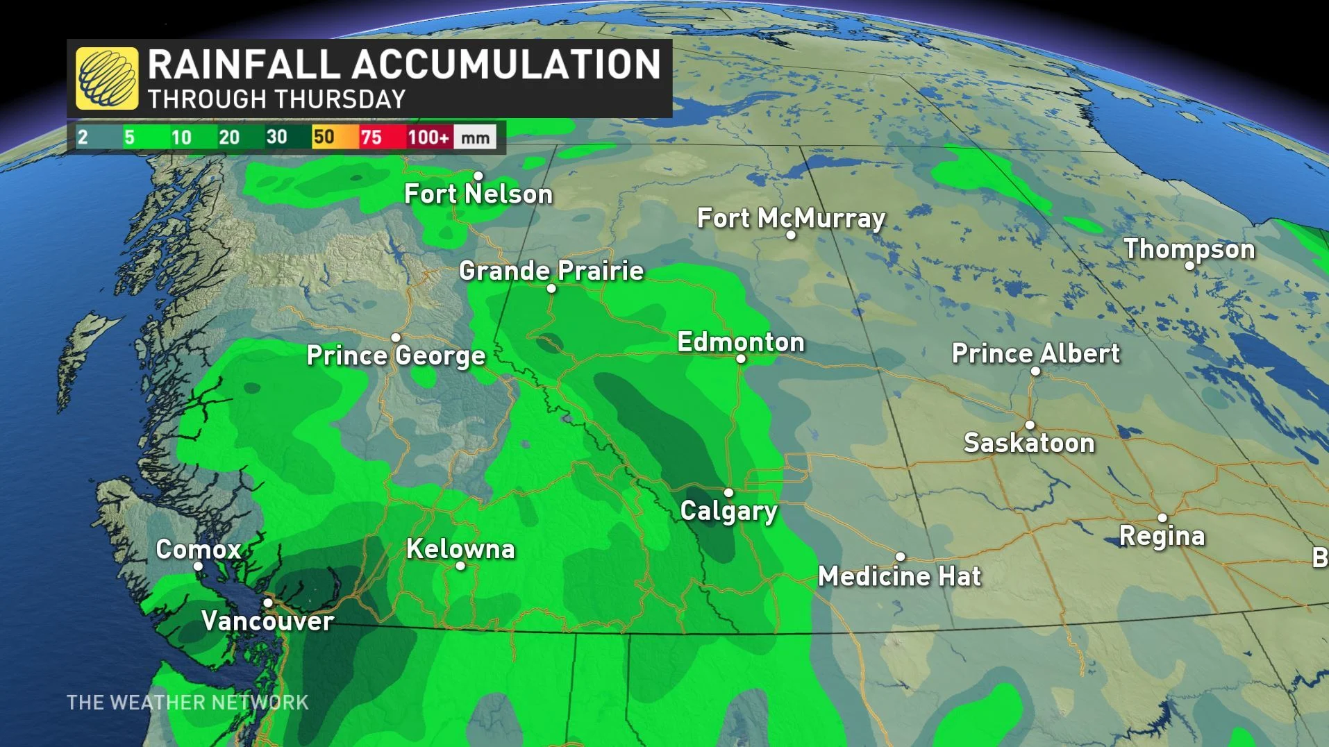
The system brought some heavy rains to parts of the province that have largely had to go without so far this season -- prior to Thursday, Victoria had only had about 8.8 mm of rain this month, so by the time these rains come to an end, it will have received more in a day than in all the rest of June.
Southern Vancouver Island and the lower mainland will see the heaviest totals by the time the last raindrops fall, though much of the rest of the province will not have been too dry either.
Afternoon thunderstorms are on the menu as well, with the risk covering almost all of the province, though lowest in those areas that have seen the highest rainfall.
We are eyeing an elevated risk that some of these storms may reach severe thresholds, with the biggest risks including heavy rainfall, strong wind gusts, and hail.
KEEP UMBRELLAS ON STANDBY
Showers are still expected on Friday, although they're likely to be spottier in nature as the upper low driving this activity pushes toward the northeast. However, Weather Network meteorologist Dr. Doug Gillham says there's still a chance of unsettled weather through the weekend, mostly in the interior.
"Cooler than seasonal temperatures to start the weekend, but then trending to near seasonal by the end of the weekend and most of next week – potentially a couple of degrees above seasonal for the south coast," Gillham says, adding it will be warmer than normal across the northwest of the province.
Stay with us here at The Weather Network for your latest forecast updates.