
Ontario cools down as heat is erased, but thunderstorm chance lingers

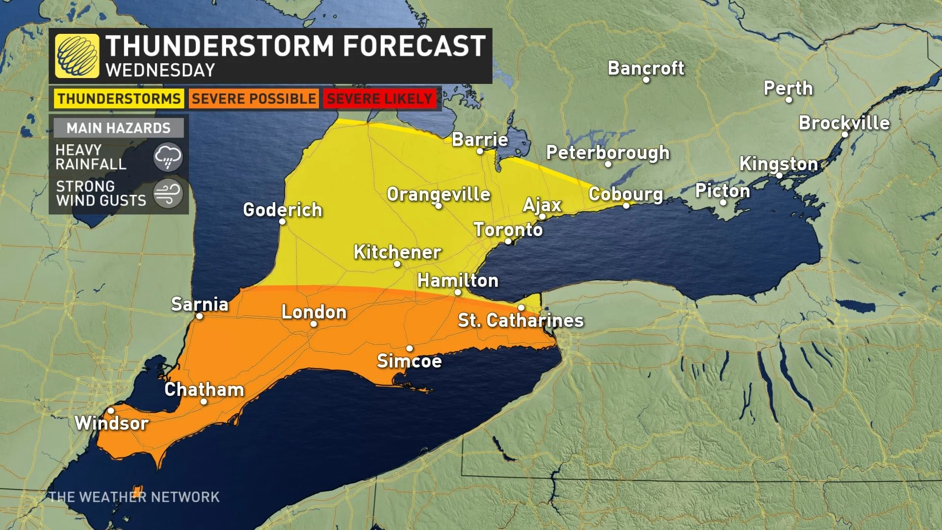
The heat will be all but gone in most of southern Ontario Wednesday, with a noticeable contrast in temperatures in the region. What will be sticking around is the thunderstorm chance, with the risk of some reaching severe limits confined to the southwestern section.
A cold front will put an end to the brief round of heat and humidity for most of southern Ontario Tuesday night. Temperatures will drop considerably in parts of the province Wednesday, with some areas only reaching the mid-teens. The extreme southwest will remain warm, however, with daytime highs sitting near the 30-degree mark still. The unsettled weather will continue, though, with the risk for thunderstorms hanging in in parts of southern Ontario. The threat for storms to reach severe criteria will be confined to the southwest, with the much warmer air in play. By Thursday, most areas will see quite chilly, with daytime highs no warmer than in the teens. The potential for thunderstorms will persist, as well, lingering into late week before clearing out for the weekend. More on the timing and impacts, below.
Visit our Complete Guide to Summer 2021 for an in-depth look at the Summer Forecast, tips to plan for it and much more!
WEDNESDAY/THURSDAY: COOLDOWN FOR MOST, BUT RAIN AND STORM CHANCES HANG ON
The high heat and humidity will be wiped clean Tuesday night after the cold front pushes through. While temperatures drop noticeably across most of southern Ontario Wednesday, the exception will be southwestern Ontario, where temperatures will be close to the 30-degree mark still.
A warm front moving through will bring the risk for thunderstorms in the south Wednesday afternoon, with the chance of severe storms confined to the southwest where the warmer air will be.
MUST SEE: Canada's scorching summer may only be getting started: Exclusive July Outlook
The main threats will be heavy rainfall and strong wind gusts with any severe storms.
There will be quite a contrast in temperatures Wednesday, from the mid-teens in cottage country and eastern Ontario to near 30°C in the extreme southwest. The GTA will see daytime highs in the low- to mid-20s.
Thursday will continue to be chilly, with temperatures remaining in the teens from cottage Country to eastern Ontario, stretching into most of southern Quebec. Similar to Wednesday, there will be more showers and thunderstorms across the region as a result of the warm front.
LOOK AHEAD: LINGERING UNSETTLED WEATHER LATE WEEK, CLEARING OUT FOR THE WEEKEND
Showers and thunderstorms will linger through much of Friday across eastern Ontario and southern Quebec, but it will be partly sunny with just a low risk for a shower in southern Ontario.
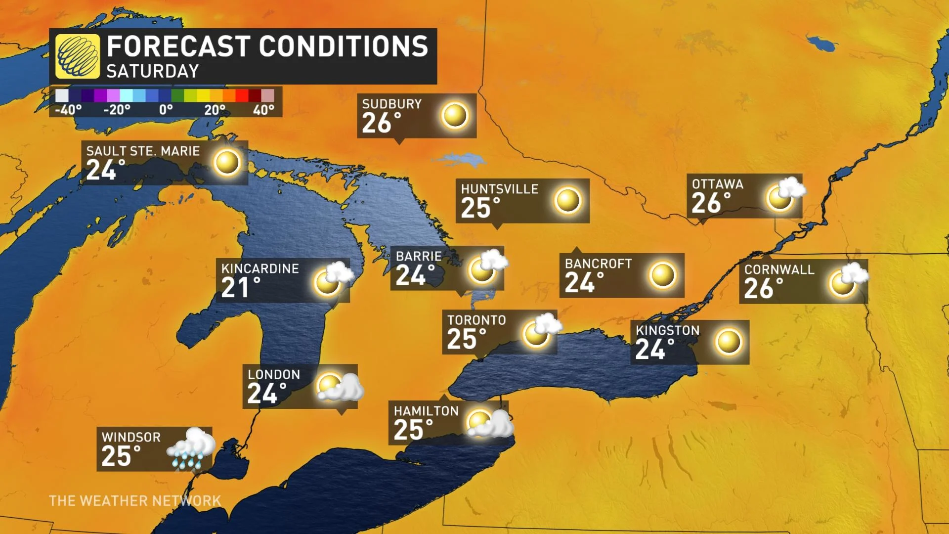
Most of southern Ontario can expect abundant sunshine and pleasant conditions for the weekend. It looks like the next system will track well south of the border, bringing the threat for showers in southwestern Ontario, so abundant sunshine and near seasonal temperatures are expected for the rest of the region.
The threat for thunderstorms will return next week, accompanied by near seasonal temperatures.
Be sure to check for the latest updates on the weather in your area.