B.C.: Snowfall warnings issued for South Coast, including Vancouver

January may be behind us, but snowy systems targeting Vancouver definitely aren't. The first week of February is set to continue the trend of active winter weather for the west as a new system threatens up to 20 cm of snow and widespread travel troubles for the South Coast on Tuesday and Wednesday. We break down what you need to know, and when your commute stands to suffer, below.
WEATHER HIGHLIGHTS:
Snow begins to spread through southern Van Island, Lower Mainland early Tuesday
Widespread significant accumulations for Lower Mainland, including Metro Vancouver
Transition from rain to snow expected for lower elevations by Wednesday
Stay up-to-date on the ALERTS in your area
THROUGH TUESDAY AFTERNOON: WIDESPREAD SNOW, TRANSITION TO HEAVY RAIN
British Columbia gets a well-deserved break from the heavy rain on Monday a soggy January that featured mudslides and a local state of emergency in the Cowichan region to end the month.
This brief break will quickly come to an end, however, as a low pressure system tracks into the region late Monday, bringing the next round of rain and snow into the South Coast for Tuesday morning.
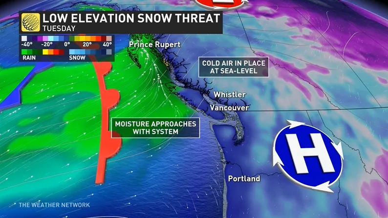
Snow will begin for the higher terrain of Vancouver Island and the Central and Sunshine coasts through the early morning hours Tuesday, spreading to southern Vancouver Island and the Lower Mainland in time for the morning commute.
Once snow sets up, cold air in place for the morning will keep the flakes flying through much of the day away from the immediate coasts. Some mixing of rain and snow is likely by Tuesday afternoon for places like downtown Victoria and near the airport for Vancouver.
Given the entrenched cold air, however, downtown Vancouver and much of the Metro area looks to see some significant snow accumulations from this system. As much as 15 cm is possible for parts of the Metro, including downtown and Burnaby, with increasing amounts farther north of the Fraser River.
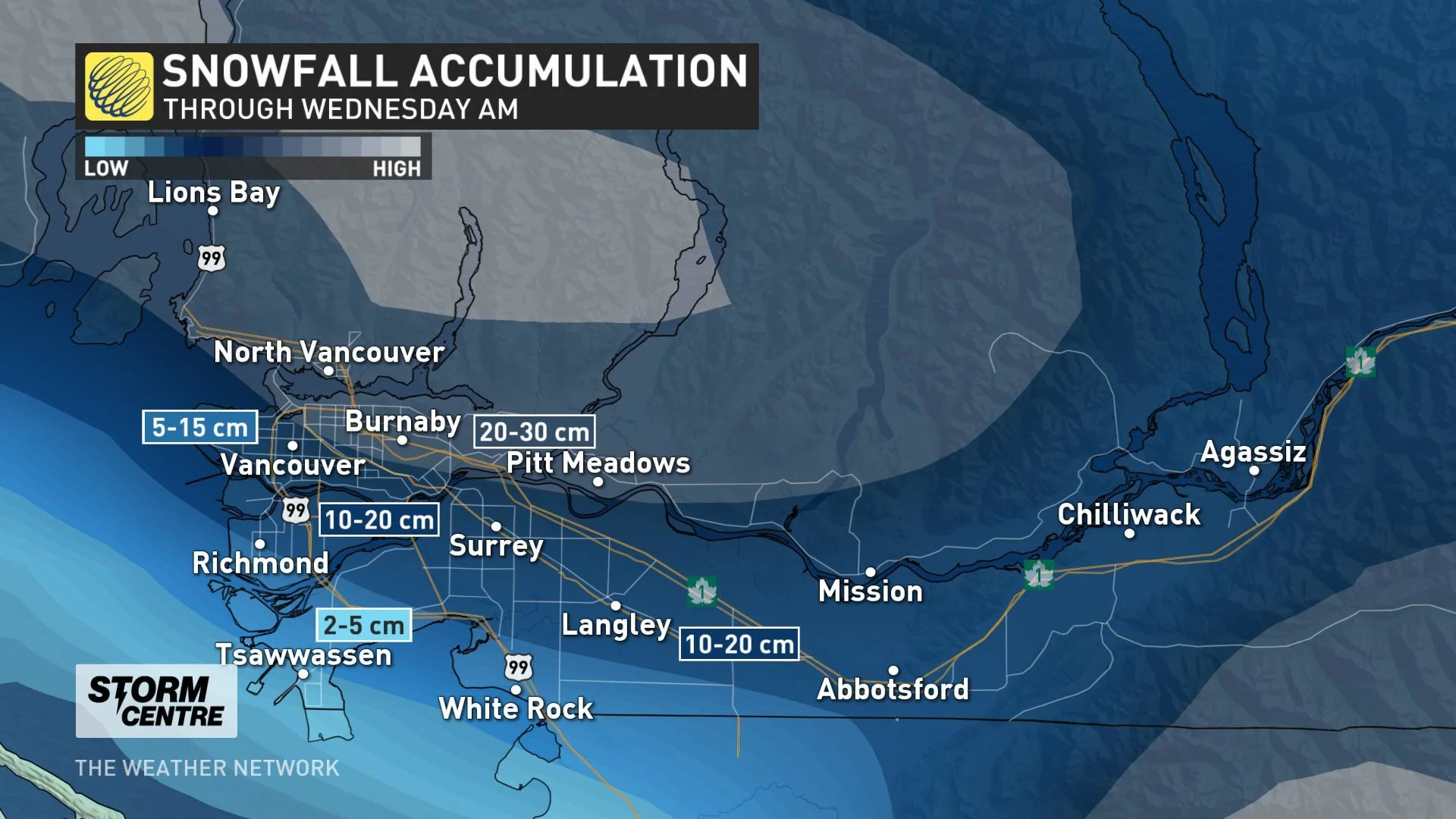
TUESDAY NIGHT/WEDNESDAY: SNOW CONTINUES FOR PARTS OF LOWER MAINLAND
Snow continues Tuesday night into Wednesday for much of the Lower Mainland, including Metro Vancouver, though milder air and southwest winds will start to eat away at the cold overnight.
That paves the way for a more widespread changeover to rain for the region through the pre-dawn hours on Wednesday. Much of southern Vancouver Island should switch entirely to rain through the overnight hours, with the snow finally changing to rain shortly before dawn for much of the Vancouver metro.
According to Weather Network meteorologist Matt Grinter, this event will be similar to the storm on January 10, which featured approximately 8 cm of snow for Vancouver International and 20 cm for Coquitlam.
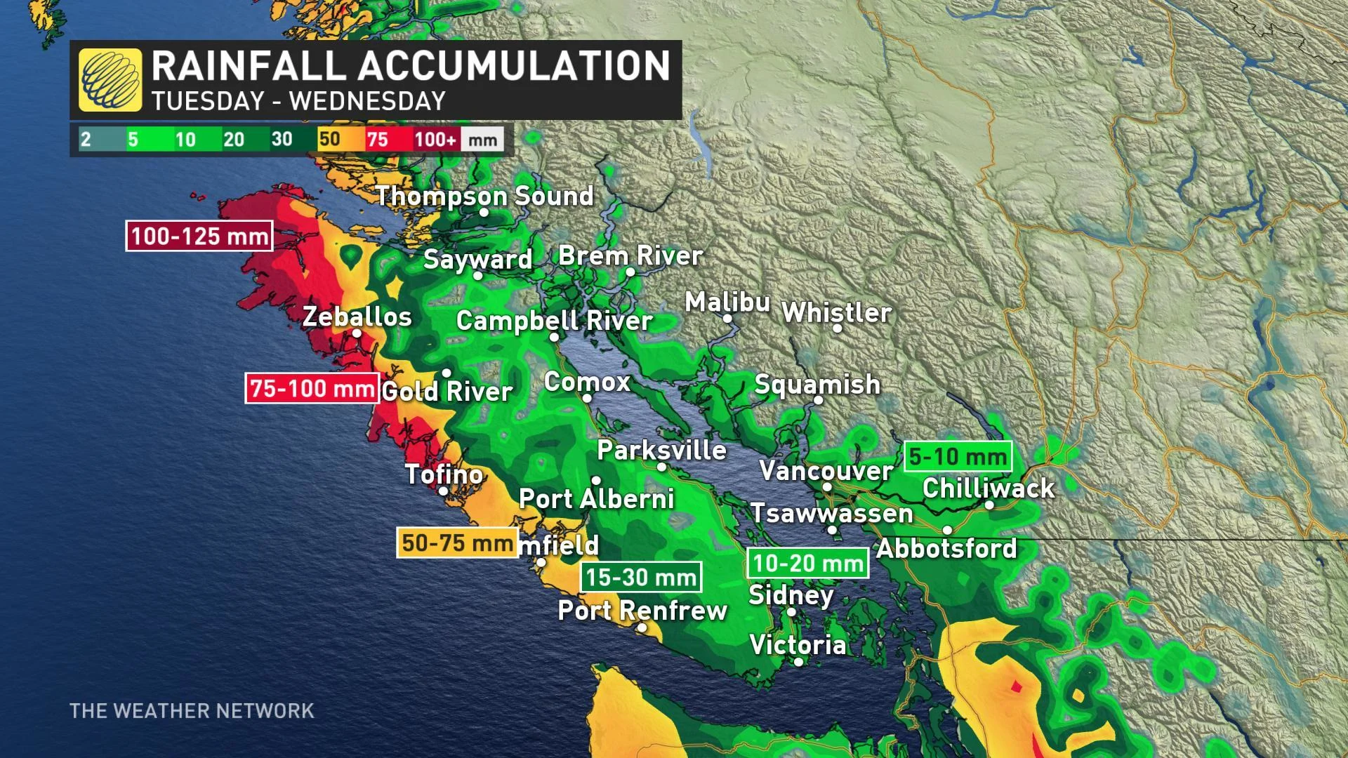
Winds are not expected to be an issue with this system throughout Tuesday, although gusts could reach between 50 to 70 km/h through the Strait of Georgia.
Be sure to check back as we continue to monitor the impact of this system closely.


