
Maritimes will see heavy rain, 20-40cm of snow for Newfoundland

Active pattern sets up in Atlantic Canada this week with the first system set to bring blizzard-like conditions, 20-40 cm of snow to the Avalon
The sloppy, wintry system will bring snow, rain and freezing rain across Nova Scotia throughout Tuesday morning. The stormy weather will then track into Newfoundland during the afternoon and evening hours and that is where the most significant impacts from this system will be. Between 20-40 cm of snow is possible for the Avalon and gusting winds could create blowing snow and blizzard-like conditions. Details and timing, below.
RELATED: Right on cue, Sheila and her brush take aim on Newfoundland
WEATHER HIGHLIGHTS:
Upwards of 30 mm of rain for coastal Nova Scotia, strong winds, 20-40 cm of snow for the Avalon
Special weather statements issued in Nova Scotia, Newfoundland
Stay up-to-date on the weather ALERTS in your area
TUESDAY: SNOW AND RAIN BECOMES WIDESPREAD
A potent low pressure system will bring snow to Nova Scotia on Tuesday morning before trekking east to Cape Breton and P.E.I. The snow will then switch over to rain for the southern coast of Nova Scotia and rainfall totals are expected to be heaviest along the southern shores, where many areas could get between 20 and 30 mm.
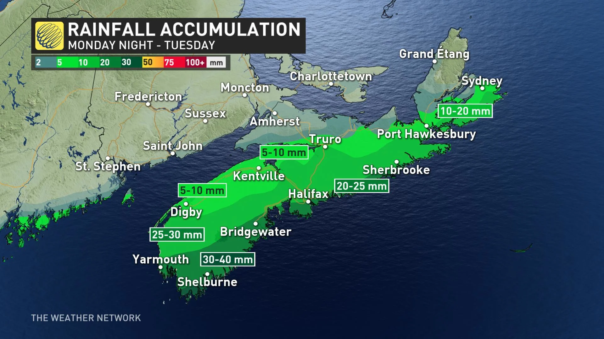
The rainfall will be lighter for much of the northern shores, where 10-20 mm is possible. Environment Canada has issued special weather statements across Nova Scotia warning of rain that could become heavy at times.
SEE ALSO: Right on cue, Sheila and her brush take aim on Newfoundland
The highest accumulations of snow in the Maritimes will be in Cape Breton where 15 to 20 cm is possible. Extreme parts of southwestern New Brunswick could see 5-10 cm of snow.
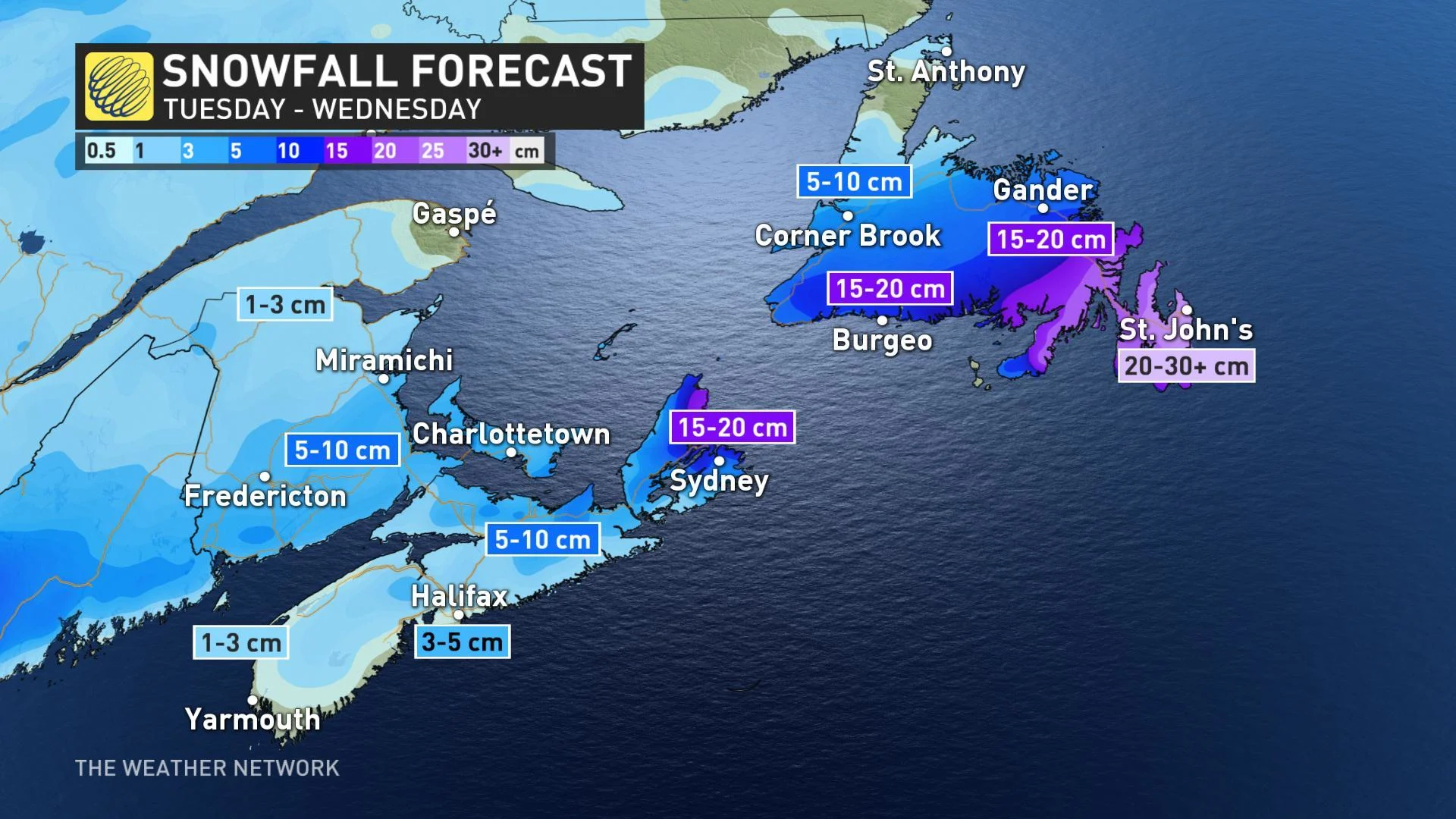
By Tuesday evening the snow will have reached Newfoundland and will be at its heaviest. Accumulations of 20-40 cm of snow is expected for the Avalon. Coupled with strong winds of up to 90 km/h, it will create blizzard-like conditions with whiteouts for much of the southern and eastern areas including the Avalon.
Special weather statements have been issued by Environment Canada for the Avalon Peninsula, Burin Peninsula, St. John's, Clarenville and nearby areas.
Snow will continue until Wednesday morning, when it will change over to mixing.
WATCH BELOW: NEWFOUNDLAND PREPARES FOR THE WRATH OF SHEILA'S BRUSH
LATE WEEK: ANOTHER STORM TO BRING MESSY WEATHER
The active pattern will bring another storm will into the region late Thursday through Friday night as a large system from the Atlantic tracks north into the Gulf of St. Lawrence with strong winds. While the exact track is still uncertain, a wide range of messy weather is expected for much of the region.
"At this point it looks like primarily rain (starting as snow and ice) for much of Newfoundland, but a swath of heavy snow with strong winds is expected for parts of the Maritimes," says Weather Network meteorologist Dr. Doug Gillham.
There may not be much of a break in the unsettled weather, as there is potential for another messy system to move in at the end of the weekend and into early next week as a Colorado low tracks into the region.
Check back for more updates and details as we continue to monitor the forecast.