Atlantic: One more pleasant day for Maritimes before conditions turn cool, wet

The Maritimes will enjoy one more day of sunshine and milder temperatures before some unsettled weather takes hold into early next week
This weekend has been a tough one for Newfoundland's Avalon Peninsula, having to endure some gloomy weather while its Maritime neighbours enjoy pleasant temperatures and plenty of sunshine. This trend will continue Sunday. But there is reason to be hopeful: A ridge of high pressure will mostly block an incoming storm systemm from entering the region early next week. A closer look, below.
WEATHER HIGHLIGHTS:
Gorgeous Sunday for Maritimes, but snow continues to linger in parts of Newfoundland, mainly the Avalon
Incoming system Sunday night looks set to just miss the region
Temperatures drop Monday
Stay up-to-date on the weather ALERTS in your area
SUNDAY: SUNSHINE AND NEAR-MISS FOR THE REGION
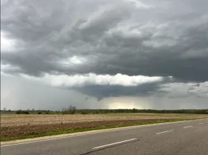
Most of the Atlantic has enjoyed abundant sunshine and slightly above seasonal temperatures this weekend, giving people in the Maritimes and most of Newfoundland a break from the recent wintry weather. This will continue Sunday but conditions will become much cooler by Monday.

The one exception to the gorgeous weather has been, and will continue to be, Newfoundland's Avalon Peninsula. It has been brushed by a system that's brought a few centimetres of snow on the weekend.
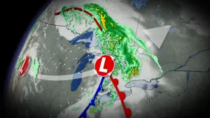
The next system will be a Colorado low moving in from Ontario, but its impacts will be limited due to blocking from a strong ridge of high pressure over Labrador. While the ridge will prevent the low from progressing across Atlantic Canada, as it dies out, unsettled conditions are expected to linger over the region through early next week.
MONDAY AND BEYOND: UNSETTLED, COOL CONDITIONS
Its effects will move into the region Sunday night and linger through Tuesday, mostly limited to the Maritimes. Snowfall-wise, 5-10 cm of snow is expected for western New Brunswick and less than 2 cm for parts of southwestern Nova Scotia. Most of the latter just see some passing showers for Nova Scotia.

Temperatures will drop a few degrees, back down to near seasonal or slightly below for much of the region.
The next Newfoundland system will also have a relatively light impact, targeting eastern areas, largely avoiding the Avalon this time, Monday with 5-10 cm of snow through Tuesday. Beyond that, another significant system is possible for the region at the end of next week.
Check back for more updates and details as we continue to monitor the forecast.