Atlantic: Rain, snow continue as unsettled pattern persists

The unsettled weather will linger throughout the rest of the week with another round of wet snow possible on Thursday.
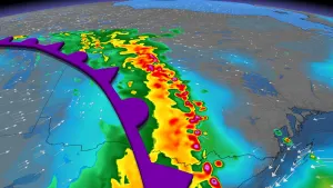
The low-pressure system currently impacting Atlantic Canada will focus its heaviest effects on Newfoundland Tuesday, with some lingering effects in the eastern Maritimes. Its effects will taper off by Wednesday, but another messy system is threatening an additional round of wet snow on Thursday. Details and timing, below.
WEATHER HIGHLIGHTS
Heavy snow in western Newfoundland, downpours in eastern Newfoundland
Temperatures continue to fall
More unsettled weather late week
Keep on top of weather ALERTS in your area
TUESDAY: RAIN AND SNOW AS TEMPERATURES DROP
Some wet snow may linger Tuesday in P.E.I., eastern Nova Scotia and eastern New Brunswick as the low pressure system tracks eastward, but the bulk of Tuesday's snowfall is expected for central and western parts of Newfoundland.
Some 5-15 cm is possible for those regions, with Labrador and the Northern Peninsula reaching and possibly exceeding the 20 cm mark by the time it comes to a close Wednesday morning.

The Avalon doesn't look to get any snow this time around, but the peninsula, along with much of eastern Newfoundland, is in line for a hefty amount of rain through Tuesday with 20-30 mm, and possibly as much as 40 mm expected for some areas, while east-central areas of the province could get up to 25 mm.
Back across the Gulf, some lingering showers appear in P.E.I. and parts of New Brunswick.

Effects from the system will taper off on Wednesday morning as it departs the region.
LOOK AHEAD: MORE UNSETTLED WEATHER, POTENTIAL WEEKEND SYSTEM
There won't be much of a break in the unsettled weather as another system will track south of the Maritimes.
Rain could change over to wet snow in Nova Scotia during the evening hours on Thursday and some localized accumulations could reach 5 cm. The precipitation in Newfoundland will be primarily wet snow northwest of the Avalon, including in Gander.
There is also the potential for a stronger system to track across Atlantic Canada on the weekend with gusty winds and rain, with snow on the back side of the system. Cooler than seasonal temperatures will dominate next week.
Check back as we continue to monitor the forecast.