Atlantic comes roaring to life with Gonzalo, Tropical Depression 8

The temporary pause on the Atlantic hurricane season is no more, with Tropical Storm Gonzalo and Tropical Depression 8 both churning in the ocean.
Gonzalo, which became a named storm on Wednesday, is currently located about 1,305 km east of the southern Windward Islands, while packing maximum sustained winds of 95 km/h, with higher gusts, the National Hurricane Center (NHC) said.
It is currently moving west near 20 km/h. Some strengthening is forecast during the next day or two, and there is still a chance that Gonzalo could become a hurricane. A hurricane watch is in effect for Barbados and St. Vincent and the Grenadines. A tropical storm watch is in effect for Tobago and Grenada.
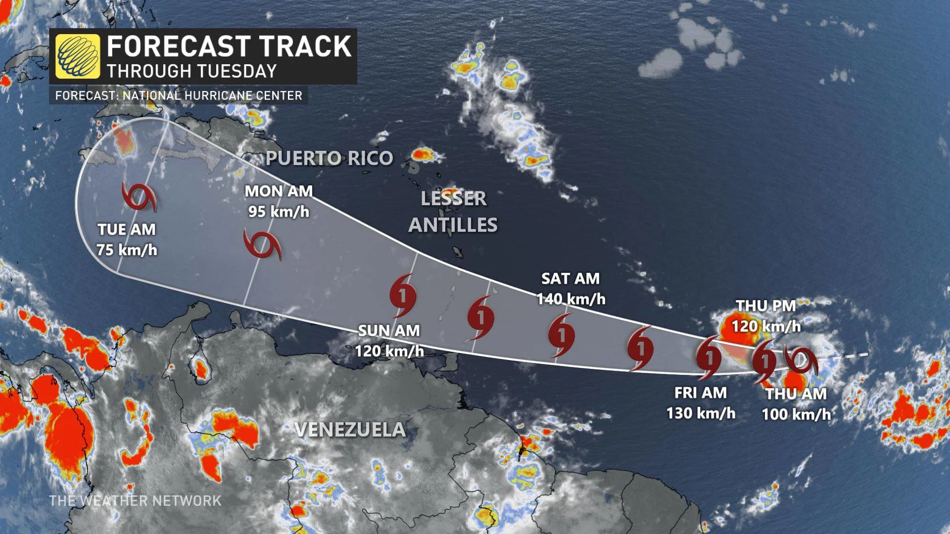
"Gonzalo is expected to produce total rain accumulations of 2 to 5 inches (50-125 mm), with isolated maximum amounts of 7 inches (180 mm) in Barbados and the Windward Islands from Friday night through Sunday night. Gonzalo is also expected to produce total rain accumulations of 1 to 2 inches (25-50 mm) in Trinidad and Tobago. Rainfall in Barbados and the Windward Islands could lead to life-threatening flash floods," NHC said in its latest update.
According to Phillip Klotzbach, a Colorado State University meteorologist, it is now the earliest 7th-named storm ever in the Atlantic basin. The previous record belonged to Gert, which formed on July 24, 2005
TROPICAL DEPRESSION 8
Meanwhile, in the Gulf of Mexico sits Tropical Depression 8 moving west-northwest near 13 km/h. The centre of the depression is expected to move across the northwestern Gulf of Mexico through Friday, with a projected landfall along the Texas coast on Saturday.
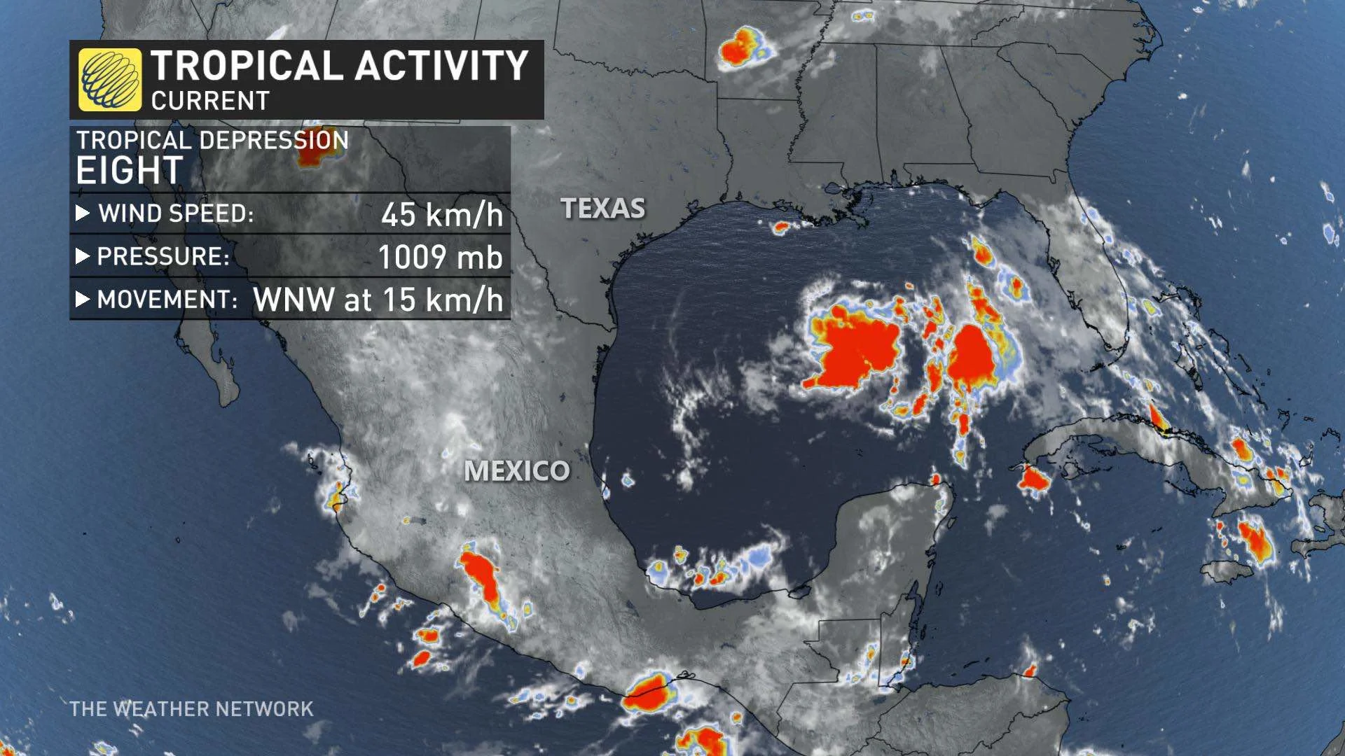
Maximum sustained winds are near 55 km/h with higher gusts. Slow strengthening is expected and the depression could become a tropical storm in a day or so. If the depression becomes a named storm, it will take on the Hanna designation.
"The tropical depression is expected to produce 3 to 5 inches (75-125 mm) of rain with isolated maximum totals of 10 inches (250 mm) through Monday along the Gulf Coast of the United States from Louisiana to south Texas, and inland to the Mexican states of Coahuila, Nuevo Leon, and northern Tamaulipas. This rain may result in life-threatening flash flooding, rapid rises on small streams, and isolated minor-to-moderate river flooding," the NHC statement reads.
FALL MAY BE MORE EXTREME THAN NORMAL
The Atlantic hurricane season in the autumn may be more extreme than usual, the German reinsurer Munich Re said Thursday.
La Nina weather conditions that are forecast can intensify tropical cyclones, the agency said in a report on natural disasters.
During the first six months in 2020, natural disasters resulted in $68 billion in losses, lower than the average of the past 30 years, according to Munich Re.
With files from Reuters.


